- Det Udom District
-
Det Udom
เดชอุดม— Amphoe — Amphoe location in Ubon Ratchathani Province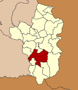
Coordinates: 14°54′11″N 105°4′35″E / 14.90306°N 105.07639°ECoordinates: 14°54′11″N 105°4′35″E / 14.90306°N 105.07639°E Country  Thailand
Province Ubon Ratchathani Seat Tambon Muban Amphoe established Area - Total 1,189.0 km2 (459.1 sq mi) Population (2005) - Total 169,896 - Density 142.9/km2 (370.1/sq mi) Time zone THA (UTC+7) Postal code 34160 Geocode 3407 Det Udom (Thai: เดชอุดม) is a district (Amphoe) in the southern part of Ubon Ratchathani Province, northeastern Thailand.
Geography
Neighboring districts are (from the northwest clockwise) Samrong, Warin Chamrap, Na Yia, Phibun Mangsahan, Buntharik, Na Chaluai, Nam Yuen, Nam Khun, Thung Si Udom of Ubon Ratchathani Province and Benchalak of Sisaket Province
Administration
The district is subdivided into 16 subdistricts (tambon), which are further subdivided into 229 villages (muban). Mueang Det is a town (thesaban mueang) covering parts of the same-named tambon. There are also three townships (thesaban tambon) - Na Suang and Bua Ngam each cover parts of the same-named tambon, and Kut Prathai covers the whole tambon Kut Prathai. There are further 10 Tambon administrative organizations (TAO).
No. Name Thai name Villages Inh. 1. Mueang Det เมืองเดช 31 32,919 2. Na Suang นาส่วง 12 8,943 4. Na Charoen นาเจริญ 11 6,963 6. Thung Thoeng ทุ่งเทิง 15 8,180 8. Som Sa-at สมสะอาด 12 10,413 9. Kut Prathai กุดประทาย 20 12,613 10. Top Hu ตบหู 21 11,406 11. Klang กลาง 17 14,269 12. Kaeng แก้ง 11 7,866 13. Tha Pho Si ท่าโพธิ์ศรี 10 6,477 15. Bua Ngam บัวงาม 16 11,953 16. Kham Khrang คำครั่ง 10 6,180 17. Na Krasaeng นากระแซง 12 13,020 20. Phon Ngam โพนงาม 12 8,585 21. Pa Mong ป่าโมง 10 4,535 23. Non Sombun โนนสมบูรณ์ 9 5,574 Missing numbers are tambon which now form the district Na Yia and Thung Si Udom.
Mueang Ubon Ratchathani · Si Mueang Mai · Khong Chiam · Khueang Nai · Khemarat · Det Udom · Na Chaluai · Nam Yuen · Buntharik · Trakan Phuet Phon · Kut Khaopun · Muang Sam Sip · Warin Chamrap · Phibun Mangsahan · Tan Sum · Pho Sai · Samrong · Don Mot Daeng · Sirindhorn · Thung Si Udom · Na Yia · Na Tan · Lao Suea Kok · Sawang Wirawong · Nam Khun
Categories:- Amphoe of Ubon Ratchathani
- Isan geography stubs

Wikimedia Foundation. 2010.