- 2009–10 South-West Indian Ocean cyclone season
-
2009–10 South-West Indian Ocean cyclone season 
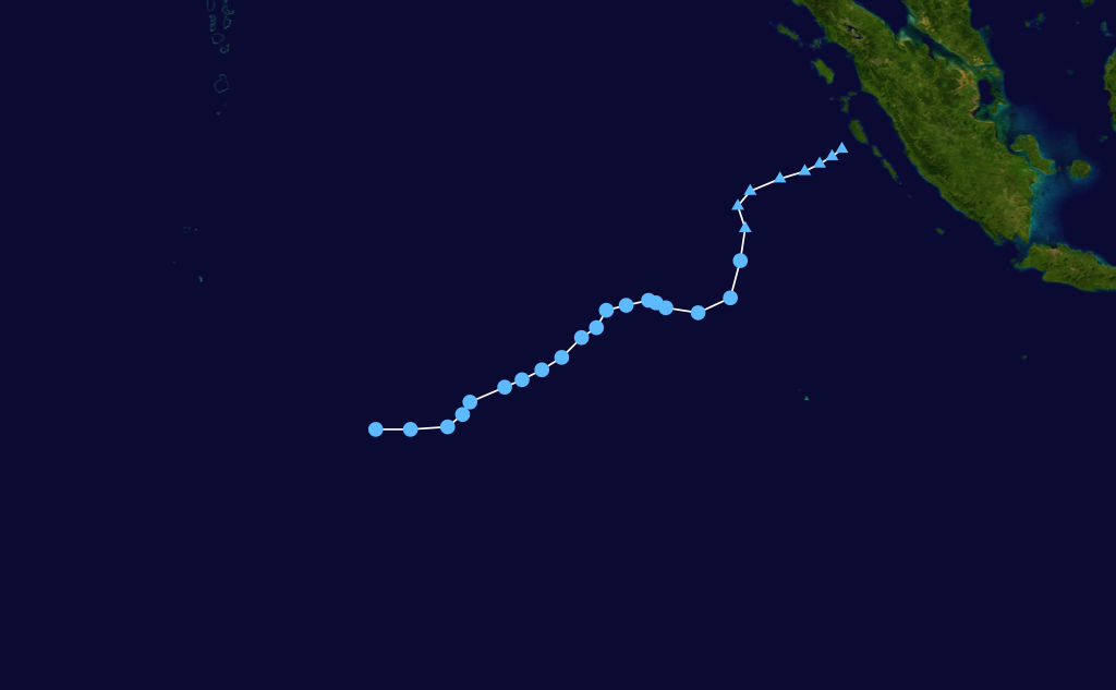
Season summary mapFirst storm formed: August 18, 2009 (01) Last storm dissipated: May 29, 2010 (Joel) Strongest storm: Edzani – 905 hPa (mbar), 220 km/h (140 mph) (10-minute sustained) Total disturbances: 16 Tropical depressions: 12 Total storms: 10 Tropical cyclones: 5 Intense cyclones: 2 Total fatalities: 40 Total damage: Unknown South-West Indian Ocean cyclone seasons
2007–08, 2008–09, 2009–10, 2010–11Related articles: - Timeline of the 2009–10 South-West Indian Ocean cyclone season
- 2009–10 Australian region cyclone season
- 2009–10 South Pacific cyclone season
The 2009–10 South-West Indian Ocean tropical cyclone year officially started on July 1, 2009, and ended on June 30, 2010, after incorporating the tropical cyclone season which ran from November 1 to April 30 for all areas except for Mauritius and the Seychelles, for which it ended on May 15, 2010. In this basin which officially runs from 30 to 90E and is to the south of the equator, the main warning center is the Regional Specialized Meteorological Center on La Reunion Island; however they delegate the naming of Cyclones to the Meteorological services of Mauritius and Madagascar.[1]
It was predicted by the Mauritius Meteorological service that there would be between nine and eleven named storms in the South West Indian Ocean during the season.[2] Their further assessment that there was a good probability of a named storm forming in November was justified when Tropical Cyclone Anja formed on November 14.
Storms
See also: Timeline of the 2009-10 South-West Indian Ocean cyclone seasonTropical Disturbance 01
Tropical disturbance (MFR) 

Duration August 18 – August 21 Intensity 35 km/h (25 mph) (10-min), 1004 mbar (hPa) Early on August 17, the JTWC reported that an area of disturbed weather had formed about 1200 kilometres, (750 miles), to the east of Diego Garcia.[3] The convection had a developed low level circulation center, however convection had not started to consolidate around it and was in an area of strong vertical wind shear. During that day the disturbance gradually developed further as the environment around it gradually improved and was designated as Tropical Disturbance 01 by RSMC La Reunion early the next day.[4][5] However later that day they downgraded it to a zone of disturbed weather and released their final advisory on the disturbance as it had remained weak with the low level circulation center remaining weak and exposed.[6] Over the next few days it weakened further before dissipating on August 20.[7]
Zone of Disturbed Weather 02
Zone of Disturbed Weather (MFR) 

Duration September 18 – September 20 Intensity 35 km/h (25 mph) (10-min), 1008 mbar (hPa) During September 17, both TCWC Jakarta and the JTWC reported that an area of convection had persisted about 740 km (460 mi), to the south east of Sumatra in Indonesia.[8][9] Satellite imagery was showing that the convection was slowly starting to consolidate with a well defined low level circulation centre off the western coast of Sumatra.[9] However it was not expected to develop any further due to being in area of high vertical wind shear in excess of 40 knots (74 km/h).[9] Despite this it was designated as a tropical low early the next day by TCWC Perth.[10] The JTWC then declared early the next day that the disturbance had dissipated as it crossed 90E and moved into RSMC La Reunion's area of responsibility.[11][12] TCWC Perth continued to monitor the tropical low as it slowly developed further until early on September 20 when RSMC La Reunion designated it as the second Zone of Disturbed Weather of the 2009–10 as convection had developed over the system and the amount of vertical wind shear over the system had dropped.[13][14] However they released their final advisory later that day as convection had dissipated in the northern quadrants of the system.[15]
Tropical Disturbance 03
Tropical disturbance (MFR) 

Duration November 7 – November 10 Intensity 45 km/h (30 mph) (10-min), 1002 mbar (hPa) Early on November 7, the JTWC issued a Tropical Cyclone Formation Alert on a system north of Diego Garcia. Later that day, RSMC La Reunion upgraded the system to a tropical disturbance. Despite forecasts that the system would strengthen to a depression, it was substantially affected by shear, and as a result, the JTWC cancelled their TCFA on November 9.
Tropical Cyclone Anja
Tropical cyclone (MFR) Category 3 tropical cyclone (SSHS) 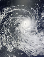

Duration November 13 – November 18 Intensity 155 km/h (100 mph) (10-min), 950 mbar (hPa) RSMC La Reunion commenced advisories on Tropical Disturbance 04 on November 14, raising the status to a Tropical Depression later the same day. At the time of formation, it was some 390 mi (630 km) south of Diego Garcia. Throughout that day, and into the 15th, Anja rapidly intensified from a severe tropical storm to a tropical cyclone on the MFR scale and a Category 3-equivalent cyclone on the Saffir-Simpson Hurricane Scale (SSHS), while remaining well away from land. The system displayed annular characteristics and was very small; its diameter was 60 nautical miles (110 km) and it displayed a pinhole eye.[16] The storm peaked at a Category 3-equivalent intensity and held its strength until November 17 when the storm rapidly weakened to a tropical storm. Final advisories were issued on November 18 as the system weakened to a depression and became extratropical.
Moderate Tropical Storm Bongani
Moderate tropical storm (MFR) Tropical storm (SSHS) 
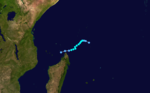
Duration November 22 – November 25 Intensity 75 km/h (45 mph) (10-min), 996 mbar (hPa) On November 22, RSMC La Reunion commenced issuing advisories for Tropical Disturbance 05 about 500 mi (800 km) northeast of Madagascar. The next day it strengthened to a Moderate Tropical Storm and was named 'Bongani'. On November 23–24, The system remained small sized and was undergoing a temporarly southeasterly constraint. According to CIMSS data (MIMIC-TPW) the dry air that was to the southwest of the system interfered with circulation of the system and temporarily limited the intensification rate. On the morning of November 24, Bongani rapidly weakened into a tropical disturbance.
The remnants of Bongani brought unsettled weather to the Mayotte Islands. Moderate rains affected the region between November 26 and 27; waves associated with the storm also averaged 3 m (9.8 ft) along coastal areas with some reaching 6 m (20 ft).[17] In the nearby Comoros Islands, waves were similarly high, with the highest reaching 5 m (16 ft).[18]
Intense Tropical Cyclone Cleo
Intense tropical cyclone (MFR) Category 4 tropical cyclone (SSHS) 

Duration December 6 – December 14 Intensity 195 km/h (120 mph) (10-min), 930 mbar (hPa) On December 6, a strong tropical disturbance 06 newly formed in the central Indian Ocean. The storm was expected to strengthen slowly, however, the next day, the disturbance strengthened into a severe tropical storm while being given a designation as Tropical Cyclone 03S by the JTWC. On 8 December it strengthened rapidly to become the first Intense Tropical Cyclone of the season and a Category 4-equivalent cyclone on the Saffir-Simpson Hurricane Scale (SSHS). It sustained this strength for a day peaked at a Category 4-equivalent intensity and held its strength as a high strong category 4-equivalent, then on the 10th slowly weakened to a category 2 equivalent cyclone. The weakening continued steadily, and the final advisory was issued on December 12 when the remnants were 370 miles (600 km) north of Rodrigues. Later that day, the remnants of Ex-Cleo regenerated to a tropical depression, but it weakened to a tropical disturbance and dissipated on December 14.
Moderate Tropical Storm David
Moderate tropical storm (MFR) Tropical storm (SSHS) 

Duration December 12 – December 25 Intensity 85 km/h (50 mph) (10-min), 987 mbar (hPa) On December 12, a zone of disturbed weather formed in the Southern Indian Ocean near the border with the Australian sector. The next day the RSMC classified it as Tropical Disturbance 07, and JTWC as Tropical Cyclone 05S, but its movement to cooler water and higher levels of wind shear weakened the tropical system on the 14th. The remnants continued to show a Low level Circulation Centre accompanied by flaring convection as they headed west or northwest, and the organisation began to improve again on the 19th. [19] It continued to organize throughout the next day, and by the 21st of December it was named Moderate Tropical Storm David by the Mauritius Meteorological Service.[20] It then reversed its direction of motion and headed east-southeast while strengthening to a Severe Tropical Storm.[21] Its strength fluctuated for the next few days, and by Christmas Day it was moving very little and windshear weakened it to a Tropical Disturbance. The final advisory from the RSMC was issued on December 25, although the remnant continued to produce bursts of poorly organized convection for several days as it reversed direction again and headed west.
In post-season analysis, David was downgraded to a Moderate Tropical Storm as winds were reassessed to have never exceeded 85 km/h (50 mph).
On December 29, the remnants of David brought heavy rain to the islands of Mauritius and Réunion. Most of Mauritius recorded over 100 mm (3.9 in) of rain within a 24-hour span, with a maximum of 146.2 mm (5.76 in) in Mon Loisir Rouillard. Widespread flash flooding took place across the island, resulting in over 20 calls to firefighters for rescue. Officials deployed special mobile forces in several cities due to the risk of increased flooding.[22]
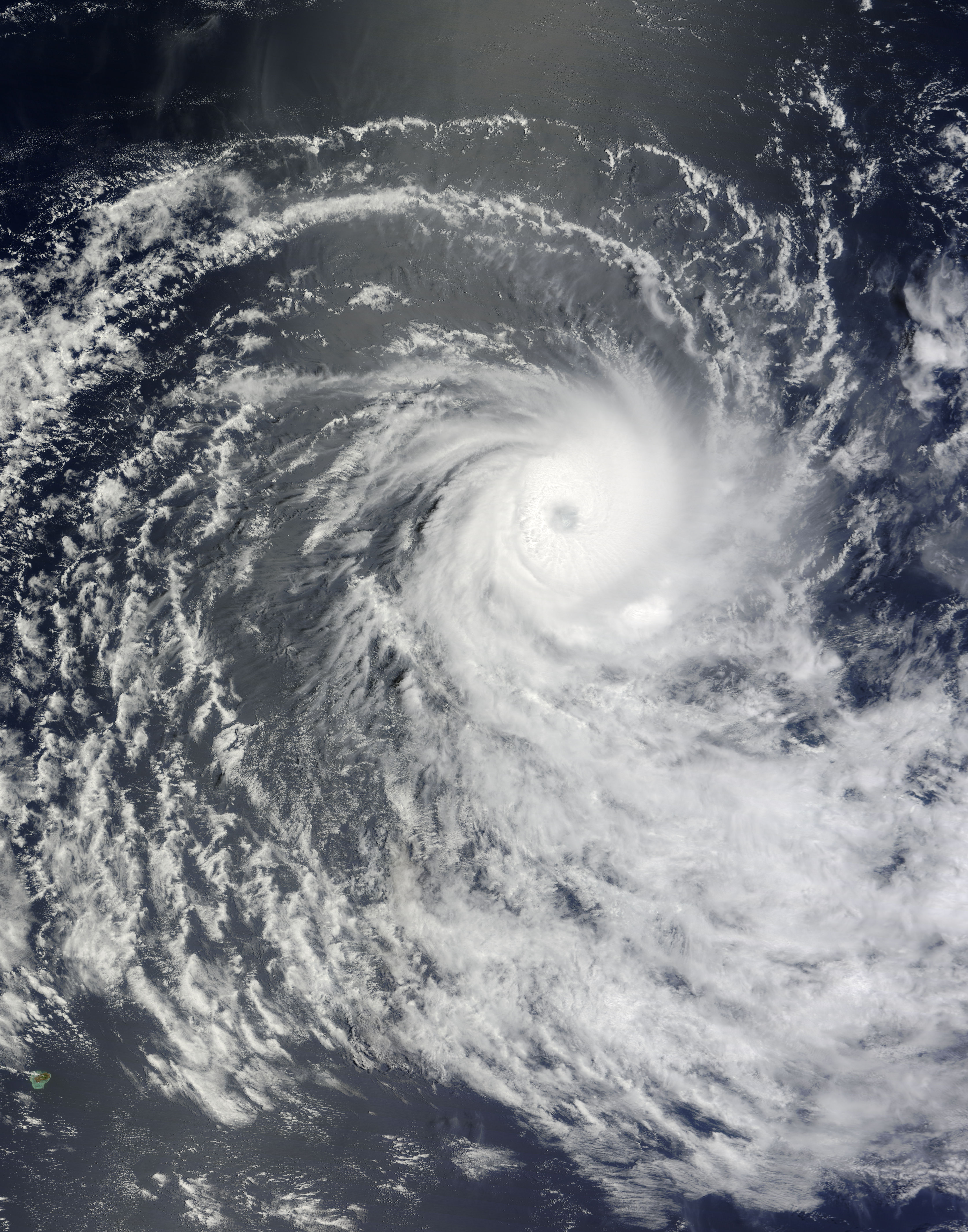
Very Intense Tropical Cyclone Edzani
Very intense tropical cyclone (MFR) Category 5 tropical cyclone (SSHS) 

Duration January 4 – January 14 Intensity 220 km/h (140 mph) (10-min), 910 mbar (hPa) Tropical Low 03U of the Australian Region crossed the 90ºE meridian on 4 January and was designated Tropical Disturbance 8 by RSMC La Réunion. The system showed two low-level circulation centres for a while, but on 5 January these consolidated, and the combination was upgraded to a Tropical Depression. At 0300 UTC on January 6, the JTWC starts issuing advisories designating the system as 07S, and shortly thereafter the RSMC upgraded it to Moderate Tropical Storm Edzani. Early on January 7, RSMC La Reunion upgraded Edzani to a Severe Tropical Storm, and it strengthened rapidly throughout the day to become an Intense Tropical Cyclone. The next day it became a Very Intense Tropical Cyclone and category 5 by JTWC, the first since Juliet in April 2005. On January 9, Edzani was downgraded to an Intense Tropical Cyclone due to decreasing sea surface temperatures. It continued to weaken during the day, as sea surface temperatures continued to decrease. By January 10, it was only a Tropical Cyclone, and within the next few days it weakened to Moderate Tropical Storm strength. The RSMC classified it as an subtropical cyclone by January 12, although JTWC treated it as tropical for 2 days longer.
Tropical Disturbance 09
Tropical disturbance (MFR) 
Duration January 15 – January 15 Intensity 45 km/h (30 mph) (10-min), 1005 mbar (hPa) An area of disturbed weather, first observed over the Mozambique Channel around 8 January, moved across northern Madagascar and into the Indian Ocean where it displayed occasional bursts of convection. On 15 January the LLCC improved in organisation, and the RSMC designated it as a Tropical Disturbance 245 nmi (454 km) to the west-southwest of La Réunion. The next day, RSMC La Reunion issued their final advisory on the system as the center was ill-defined.
Subtropical Storm 10
Subtropical storm (MFR) Tropical storm (SSHS) 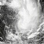

Duration January 25 – January 31 Intensity 65 km/h (40 mph) (10-min), 995 mbar (hPa) On January 26, RSMC La Réunion announced that a Zone of Disturbed Weather had formed about 350 miles (560 km) NNE of Mauritius. Next day this was raised to a Tropical Disturbance, and JTWC designated is as Tropical Cyclone 11S based on 1-minute wind strength. By January 29 it displayed hybrid characteristics and was classified as a subtropical depression, although the maximum winds reached storm strength.
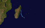
Moderate Tropical Storm Fami
Moderate tropical storm (MFR) Tropical storm (SSHS) 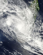

Duration February 1 – February 3 Intensity 85 km/h (50 mph) (10-min), 990 mbar (hPa) On February 1, RSMC La Reunion commenced issuing advisories for Tropical Disturbance 11 in the Mozambique Channel. On February 2 it strengthened to a Moderate Tropical Storm and was named Fami. Shortly after this it made landfall on the western Malagasy coast and weakened rapidly to a depression. Fami dissipated on February 2.
Intense Tropical Cyclone Gelane
Intense tropical cyclone (MFR) Category 4 tropical cyclone (SSHS) 
Duration February 15 – February 22 Intensity 205 km/h (125 mph) (10-min), 930 mbar (hPa) On February 15, the RSMC announced the formation of Tropical Disturbance 12 aprroximately 650 nmi (1,200 km) NNE of La Réunion. Hours later it was classified as Moderate Tropical Storm Gelane. It reached Tropical Cyclone strength briefly on February 17, but quickly weakened to a Severe Tropical Storm. Then on February 18, it restrengthened back into a Tropical Cyclone, eventually becoming an Intense Tropical Cyclone. It remained a small system and weakened rapidly as wind shear effects increased.
Severe Tropical Storm Hubert
Severe tropical storm (MFR) Tropical storm (SSHS) 

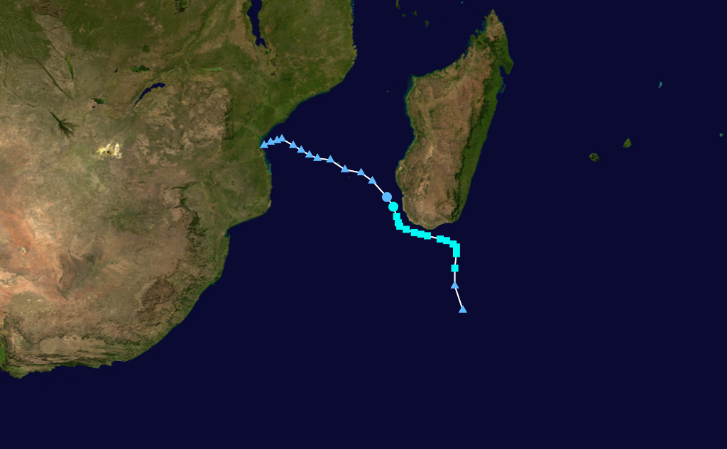
Duration March 7 – March 15 Intensity 100 km/h (65 mph) (10-min), 985 mbar (hPa) Main article: Tropical Storm HubertOn March 9, a tropical disturbance formed between Madagascar and Réunion. On March 10 it strengthened to a tropical storm and was named Hubert by the meteorological service of Madagascar. It strengthened to a severe tropical storm as it approached the Madagascar coast, and made landfall north of Mananjary. At least ten people were killed by the storm and 32,000 others were affected throughout Madagascar.[23] Later reports confirmed that four other people had been killed and two more were missing. Nearly 38,000 people were left homeless by flooding triggered by torrential rains from the storm.[24]
Tropical Cyclone Imani
Tropical cyclone (MFR) Category 1 tropical cyclone (SSHS) 

Duration March 20 – March 27 Intensity 130 km/h (80 mph) (10-min), 965 mbar (hPa) Tropical Disturbance 14 formed on 22 March in the far east of the SW Indian Ocean basin, close to 90ºE. Although the precursor disturbance had been drifting eastwards, TD 14 was predicted to remain in this basin and not move into the Australian. It became a tropical depression later the same day, and was upgraded to Moderate Tropical Storm Imani on 23 March and a Severe Tropical Storm the next day. It continued to strengthen as it moved southwards, and reached tropical cyclone strength on 25 March. It started to dissipate on March 26, and La Reunion had stopped releasing advisories on Imani at 1200z, March 26.
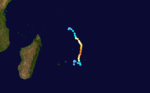
Tropical Depression 15 (Robyn)
Tropical depression (MFR) Tropical depression (SSHS) 

Duration April 7 – April 7 Intensity 55 km/h (35 mph) (10-min), 1002 mbar (hPa) The remnants of Severe Tropical Cyclone Robyn crossed into this basin on 7 April as a Filling Depression, and a single advisory was issued by RSMC La Réunion.
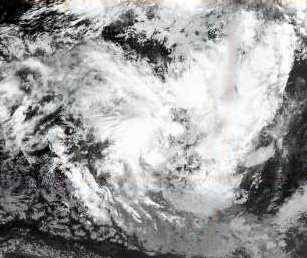
Subtropical Storm Joel
Subtropical storm (MFR) Subtropical storm (SSHS) 

Duration May 23 – May 29 Intensity 100 km/h (65 mph) (10-min), 990 mbar (hPa) An area of convection southwest of Madagascar was designated Subtropical Depression 16 by RSMC La Reunion on 26 May. The small system strengthened rapidly and was soon named Joel, although still classified as a Subtropical Depression. NASA also considered the storm to have been subtropical, attaining peak one-minute sustained winds of 85 km/h (50 mph).[25]
In post-season analysis, Joel was discovered to have briefly been a tropical storm before transitioning into a subtropical cyclone.
Storm Names
Tropical disturbances are named upon reaching moderate tropical storm strength.[26] If a tropical disturbance reaches this intensity west of 55°E, then the Sub-Regional Tropical Cyclone Advisory Centre in Madagascar assigns the appropriate name to the storm. If it reaches moderate tropical storm strength between 55°E and 90°E, then the Sub-Regional Tropical Cyclone Advisory Centre in Mauritius names the storm.[26] A new list of names is drawn up and used each year, so no names are retired.[26] The names for this season are as follows:[27]
- Anja
- Bongani
- Cleo
- David
- Edzani
- Fami
- Gelane
- Hubert
- Imani
- Joel
- Kanja (unused)
- Lunda (unused)
- Mohono (unused)
- Nigel (unused)
- Olympe (unused)
- Pamela (unused)
- Quentin (unused)
- Rahim (unused)
- Savana (unused)
- Themba (unused)
- Uyapo (unused)
- Viviane (unused)
- Walter (unused)
- Xangy (unused)
- Yemurai (unused)
- Zanele (unused)
Season effects
This table lists all the storms that developed in the Southern Hemisphere during the 2009–2010 South-West Indian Ocean cyclone season. It includes their intensity, duration, name, landfalls, deaths, and damages. All data is taken from Météo-France. The damage figures are all from 2009 USD.
RSMC/JTWC
NumberStorm
NameDates active Storm category
at peak intensityPeak 10-min
sustained windsPressure
hPaAreas affected Damage
(USD)Deaths Notes 01 N/A August 18 Tropical Disturbance 35 km/h (20 mph) 1004 None None None 02 N/A September 18 – September 20 Zone of Disturbed Weather 35 km/h (20 mph) 1008 None None None 03 N/A September 18 – September 20 Tropical Disturbance 45 km/h (30 mph) 1002 None None None 04/01S Anja November 14 – November 18 Tropical Cyclone 155 km/h (100 mph) 950 None None None 05/02S Bongani November 22 – November 25 Moderate tropical storm 75 km/h (45 mph) 997 Madagascar 06/03S Cleo December 6 – December 14 Intense tropical cyclone 195 km/h (120 mph) 925 None None None 07/05S David December 12 – December 25 Moderate tropical storm 85 km/h (50 mph) 987 Reunion, Mauritius, Madagascar 08/07S Edzani January 4 – January 14 Very intense tropical cyclone 220 km/h (140 mph) 910 None None None 09 N/A January 15 Tropical Disturbance 45 km/h (30 mph) 1005 Reunion, Mauritius, Madagascar 10/11S N/A January 26 – January 30 Subtropical depression 65 km/h (40 mph) 1005 Reunion, Mauritius, Madagascar 11/13S Fami February 1 – February 3 Moderate tropical storm 85 km/h (50 mph) 994 Madagascar 12/16S Gelane February 15 – February 22 Intense tropical cyclone 205 km/h (125 mph) 930 Reunion, Mauritius, Madagascar 13/18S Hubert March 7 – March 15 Moderate tropical storm 100 km/h (65 mph) 985 Madagascar 14/21S Imani March 20 – March 27 Tropical cyclone 130 km/h (80 mph) 965 None None None 15/23S Robyn April 7 Dépression se comblant 55 km/h (35 mph) 998 None None None 16 Joel May 26 – May 29 Subtropical depression 100 km/h (65 mph) 990 Madagascar 16 Systems August 18 – May 29 220 km/h (140 mph) 910 None None See also
- List of Southern Hemisphere cyclone seasons
- Atlantic hurricane seasons: 2009, 2010
- Pacific hurricane seasons: 2009, 2010
- Pacific typhoon seasons: 2009, 2010
- North Indian Ocean cyclone seasons: 2009, 2010
- 2009-10 Australian region cyclone season
- 2009-10 South Pacific cyclone season
References
- ^ "Tropical Cyclone Operational Plan for the South West Indian Ocean (2006)". World Meteorological Organization. 2006. http://www.wmo.int/pages/prog/www/tcp/documents/TCP12Edition2006-English.pdf. Retrieved 2009-10-25.
- ^ "The 2009 – 2010 Summer Season Outlook". Mauritius Meteorological service. 2009-10-16. http://www.webcitation.org/5kmMA7kWS. Retrieved 2009-10-25.
- ^ "Signifiicant Tropical Weather Advisory for the Indian Ocean 2009-08-17 11z". Joint Typhoon Warning Center. 2009-08-17. ftp://ftp.met.fsu.edu/pub/weather/tropical/GuamStuff/2009081711-ABIO.PGTW. Retrieved 2009-08-18.
- ^ "Signifiicant Tropical Weather Advisory for the Indian Ocean 2009-08-18 18z". Joint Typhoon Warning Center. 2009-08-17. ftp://ftp.met.fsu.edu/pub/weather/tropical/GuamStuff/2009081718-ABIO.PGTW. Retrieved 2009-08-18.
- ^ "RSMC Tropical Cyclone Bulletin 2009-08-18 00z". Météo-France. 2009-08-18. ftp://ftp.met.fsu.edu/pub/weather/tropical/Seychelles/2009081802-FMEE. Retrieved 2009-08-18.
- ^ "RSMC Technical Bulletin 2009-08-18 12z". Météo-France. 2009-08-18. ftp://ftp.met.fsu.edu/pub/weather/tropical/Seychelles/2009081812-FMEE. Retrieved 2009-08-18.
- ^ "Signifiicant Tropical Weather Advisory for the Indian Ocean 2009-08-20 18z". Joint Typhoon Warning Center. 2009-08-20. ftp://ftp.met.fsu.edu/pub/weather/tropical/GuamStuff/2009082018-ABIO.PGTW. Retrieved 2009-08-20.
- ^ "Tropical Weather Outlook: 2009-09-16 06z". Indonesian Agency for Meterology, Climatology and Geophysics. 2009-09-16. http://www.webcitation.org/5jpuLleHm. Retrieved 2009-09-18.(Indonesian)
- ^ a b c "Significant Tropical Weather Advisory for the Indian Ocean 2009-09-16 11z". Joint Typhoon Warning Center. 2009-09-16. http://www.webcitation.org/5jpuSxZuP. Retrieved 2009-09-18.
- ^ "TCWC Perth Tropical Cyclone Outlook for the Central Indian Ocean 2009-09-17 0400z". Bureau of Meteorology (Australia). 2009-09-17. http://www.webcitation.org/5jqlV1Njs. Retrieved 2009-09-18.
- ^ "Significant Tropical Weather Advisory for the Indian Ocean 2009-09-18 11z". Joint Typhoon Warning Center. 2009-09-18. http://www.webcitation.org/5jsft9kG4. Retrieved 2009-09-18.
- ^ "Operational Best Track Details for 91S Invest". Joint Typhoon Warning Center. United States Naval Research Laboratory. 2009-09-16. http://www.webcitation.org/5jswR3ovL. Retrieved 2009-09-18.
- ^ "Tropical Cyclone Outlook for the Central Indian Ocean". Bureau of Meteorology (Australia). 2009-09-20. http://www.webcitation.org/5jw2HMCeN. Retrieved 2009-12-12.
- ^ "RSMC La Reunion Tropical Cyclone Warning 2009-09-20 06z". Météo-France. 2009-09-20. ftp://ftp.met.fsu.edu/pub/weather/tropical/Seychelles/2009092007-FMEE. Retrieved 2009-12-12.
- ^ "RSMC La Reunion Tropical Cyclone Warning 2009-09-20 12z". Météo-France. 2009-09-20. ftp://ftp.met.fsu.edu/pub/weather/tropical/Seychelles/2009092013-FMEE. Retrieved 2009-12-12.
- ^ "JTWC Warning 07 for Tropical Cyclone 01S (Anja)". Joint Typhoon Warning Center. November 17, 2009. http://www.webcitation.org/5lLFoEnmr. Retrieved 2009-11-17.
- ^ (French) Staff Writer (November 26, 2009). "Bongani apporte la pluie". Mayotte Hebdo. http://www.mayottehebdo.com/content/view/1835/47/. Retrieved December 9, 2009.
- ^ (French) Hakim Ahamed Zoubeiri (November 26, 2009). "Ex-Bongani : pluie, orage et houle sur les Comores". Actualité des Iles Comoros. http://zoubeiri.unblog.fr/2009/11/26/ex-bongani-pluie-orage-et-houle-sur-les-comores/. Retrieved December 19, 2009.
- ^ "Significant Tropical Weather Advisory for the Indian Ocean". Joint Typhoon Warning Center. December 19, 2009. ftp://ftp.met.fsu.edu/pub/weather/tropical/GuamStuff/2009121909-ABIO.PGTW. Retrieved 2009-12-19.
- ^ "Moderate Tropical Storm 7 (David) Warning 09". Météo-France. December 21, 2009. ftp://ftp.met.fsu.edu/pub/weather/tropical/Seychelles/2009122112-FMEE. Retrieved 2009-12-21.
- ^ "Severe Tropical Storm 14 (David) Warning 14". Météo-France. December 22, 2009. ftp://ftp.met.fsu.edu/pub/weather/tropical/Seychelles/2009122218-FMEE. Retrieved 2009-12-22.
- ^ (French) Julien Tuyau (December 29, 2009). "Pluies diluviennes: les pompiers et la Special Mobile Force en état d'alerte". La Sentinelle. http://www.lexpress.mu/story/8593-pluies-diluviennes-les-pompiers-et-la-special-mobile-force-en-etat-d-alerte.html. Retrieved December 29, 2009.
- ^ http://breakingnews.iol.ie/news/world/tropical-storm-kills-10-in-madagascar-449731.html
- ^ http://www.webcitation.org/5oDBbhlCE
- ^ http://www.nasa.gov/mission_pages/hurricanes/archives/2010/h2010_joel.html
- ^ a b c "Tropical cyclone Operational Plan for the Southwest Indian Ocean". World Meterological Organisation. 2006. http://www.wmo.ch/web/www/TCP/OperationPlans/TCP-12%20Edition%202006-English.pdf. Retrieved 2009-08-18.[dead link]
- ^ "Tropical Cyclone Names 2009–10". 2009-08-13. http://www.meteo.fr/temps/domtom/La_Reunion/TGPR/saison/Liste_NomsBapteme.html. Retrieved 2009-08-18.
External links
- Joint Typhoon Warning Center (JTWC).
- Météo France (RSMC La Réunion).
- World Meteorological Organization
Tropical cyclones of the 2009–10 South-West Indian Ocean cyclone season
HMFR Tropical Cyclone Scale DIS TD MTS STS TC ITC VITC  Book ·
  Category ·
  Portal ·
  WikiProject ·
  Commons
2000–09 South-West Indian Ocean cyclone seasons Categories:


Wikimedia Foundation. 2010.