- Cudal, New South Wales
-
Cudal
New South Wales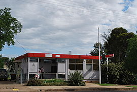
Post office
 Cudal
CudalPopulation: 389[1] Postcode: 2864 Coordinates: 33°17′S 148°45′E / 33.283°S 148.75°ECoordinates: 33°17′S 148°45′E / 33.283°S 148.75°E Location: LGA: Cabonne Shire Council State District: Dubbo, Orange Federal Division: Calare Cudal is a town in the Central West region of New South Wales, Australia. Cudal is in the Cabonne Shire Council Local Government area, 296 kilometres (184 mi) west of the state capital, Sydney. At the 2006 census, Cudal had a population of 389.[1] The place name,Cudal, could have derived from an Aboriginal word meaning 'flat'.[2]
Facilities and businesses within Cudal include a post office, police station, preschool, public school, airport, showground, sporting field, swimming pool, motel, caravan park, hotel, newsagency, takeaway store, local GP, Country Women's Association and three churches.[citation needed]
References
- ^ a b Australian Bureau of Statistics (25 October 2007). "Cudal (L) (Urban Centre/Locality)". 2006 Census QuickStats. http://www.censusdata.abs.gov.au/ABSNavigation/prenav/LocationSearch?collection=Census&period=2006&areacode=UCL123800&producttype=QuickStats&breadcrumb=PL&action=401. Retrieved 2009-01-11.
- ^ "Cudal". Geographical Names Board of New South Wales. http://www.gnb.nsw.gov.au/name_search/extract?id=JPYblMKmMn. Retrieved 14 July 2009.
External links
- About Cudal Cabonne Shire Council official website
Towns in the Cabonne Shire Local Government Area Borenore · Canowindra · Cargo · Cudal · Cumnock · Eugowra · Manildra · Molong · Mullion Creek · Nashdale · Ophir · Yeoval
Main Article: Local Government Areas of New South WalesCategories:- Towns in New South Wales
- Towns in the Central West, New South Wales
- New South Wales geography stubs


Wikimedia Foundation. 2010.