Ashburnham County

Ashburnham County
Ashburnham
New South Wales
Ashburnham NSW.PNG
Location in New South Wales
Lands administrative divisions around Ashburnham
Kennedy Gordon Wellington
Cunningham Ashburnham Bathurst
Gipps Forbes Bathurst

Ashburnham County, New South Wales is one of the 141 Cadastral divisions of New South Wales. The Lachlan River and Belubula River is the southern boundary. It includes Parkes and Forbes.

Ashburnham County was named in honour of Bertram Ashburnham, who was the 4th Earl of Ashburnham between (1797-1878).[1]

Parishes within this county

A full list of parishes found within this county; their current LGA and mapping coordinates to the approximate centre of each location is as follows:

Parish LGA Coordinates
Barrajin Cabonne Shire Council 33°29′54″S 148°45′04″E / 33.49833°S 148.75111°E / -33.49833; 148.75111 (Barrajin Parish)
Barton Cabonne Shire Council 33°15′54″S 148°57′04″E / 33.265°S 148.95111°E / -33.265; 148.95111 (Barton Parish)
Beargamil Parkes Shire Council 33°03′54″S 148°18′04″E / 33.065°S 148.30111°E / -33.065; 148.30111 (Beargamil Parish)
Bell Cabonne Shire Council 32°58′54″S 148°50′04″E / 32.98167°S 148.83444°E / -32.98167; 148.83444 (Bell Parish)
Belubula Cabonne Shire Council 33°31′54″S 148°34′04″E / 33.53167°S 148.56778°E / -33.53167; 148.56778 (Belubula Parish)
Bocobidgle Forbes Shire Council 33°20′54″S 147°56′04″E / 33.34833°S 147.93444°E / -33.34833; 147.93444 (Bocobidgle Parish)
Bindogundra Parkes Shire Council 33°09′54″S 148°21′04″E / 33.165°S 148.35111°E / -33.165; 148.35111 (Bindogundra Parish)
Boree Cabonne Cabonne Shire Council 33°16′54″S 148°49′04″E / 33.28167°S 148.81778°E / -33.28167; 148.81778 (Boree Cabonne Parish)
Boree Nyrang Cabonne Shire Council 33°11′54″S 148°54′04″E / 33.19833°S 148.90111°E / -33.19833; 148.90111 (Boree Nyrang Parish)
Bowan Cabonne Shire Council 33°19′54″S 148°50′04″E / 33.33167°S 148.83444°E / -33.33167; 148.83444 (Bowan Parish)
Brolgan Parkes Shire Council 33°07′54″S 148°03′04″E / 33.13167°S 148.05111°E / -33.13167; 148.05111 (Brolgan Parish)
Brymedura Cabonne Shire Council 33°07′54″S 148°47′04″E / 33.13167°S 148.78444°E / -33.13167; 148.78444 (Brymedura Parish)
Bumberry Parkes Shire Council 33°08′54″S 148°27′04″E / 33.14833°S 148.45111°E / -33.14833; 148.45111 (Bumberry Parish)
Canomodine Cabonne Shire Council 33°31′54″S 148°50′04″E / 33.53167°S 148.83444°E / -33.53167; 148.83444 (Canomodine Parish)
Cargo Cabonne Shire Council 33°25′54″S 148°50′04″E / 33.43167°S 148.83444°E / -33.43167; 148.83444 (Cargo Parish)
Carrawabbity Forbes Shire Council 33°21′54″S 147°51′04″E / 33.365°S 147.85111°E / -33.365; 147.85111 (Carrawabbity Parish)
Canobolas Cabonne Shire Council 33°19′54″S 148°58′04″E / 33.33167°S 148.96778°E / -33.33167; 148.96778 (Canobolas Parish)
Collett Cabonne Shire Council 33°31′54″S 148°42′04″E / 33.53167°S 148.70111°E / -33.53167; 148.70111 (Collett Parish)
Cookamidgera Parkes Shire Council 33°14′54″S 148°16′04″E / 33.24833°S 148.26778°E / -33.24833; 148.26778 (Cookamidgera Parish)
Coonambro Forbes Shire Council 33°14′54″S 148°22′04″E / 33.24833°S 148.36778°E / -33.24833; 148.36778 (Coonambro Parish)
Cudal Cabonne Shire Council 33°16′54″S 148°43′04″E / 33.28167°S 148.71778°E / -33.28167; 148.71778 (Cudal Parish)
Cumble Cabonne Shire Council 33°04′54″S 148°42′04″E / 33.08167°S 148.70111°E / -33.08167; 148.70111 (Cumble Parish)
Currajong Parkes Shire Council 33°04′54″S 148°04′04″E / 33.08167°S 148.06778°E / -33.08167; 148.06778 (Currajong Parish)
Curumbenya Parkes Shire Council 33°02′54″S 148°25′04″E / 33.04833°S 148.41778°E / -33.04833; 148.41778 (Curumbenya Parish)
Dowling Forbes Shire Council 33°16′54″S 148°09′04″E / 33.28167°S 148.15111°E / -33.28167; 148.15111 (Dowling Parish)
Dulladerry Cabonne Shire Council 33°12′54″S 148°37′04″E / 33.215°S 148.61778°E / -33.215; 148.61778 (Dulladerry Parish)
Edinburgh Cabonne Shire Council 33°24′54″S 148°55′04″E / 33.415°S 148.91778°E / -33.415; 148.91778 (Edinburgh Parish)
Eugowra Forbes Shire Council 33°22′54″S 148°20′04″E / 33.38167°S 148.33444°E / -33.38167; 148.33444 (Eugowra Parish)
Forbes Forbes Shire Council 33°21′54″S 148°02′04″E / 33.365°S 148.03444°E / -33.365; 148.03444 (Forbes Parish)
Goimbla Cabonne Shire Council 33°22′54″S 148°32′04″E / 33.38167°S 148.53444°E / -33.38167; 148.53444 (Goimbla Parish)
Goobang Parkes Shire Council 33°02′54″S 148°13′04″E / 33.04833°S 148.21778°E / -33.04833; 148.21778 (Goobang Parish)
Goonumbla Parkes Shire Council 33°00′54″S 148°07′04″E / 33.015°S 148.11778°E / -33.015; 148.11778 (Goonumbla Parish)
Gregra Cabonne Shire Council 33°11′54″S 148°45′04″E / 33.19833°S 148.75111°E / -33.19833; 148.75111 (Gregra Parish)
Gunningbland Parkes Shire Council 33°04′54″S 148°00′04″E / 33.08167°S 148.00111°E / -33.08167; 148.00111 (Gunningbland Parish)
Kamandra Parkes Shire Council 33°08′54″S 148°15′04″E / 33.14833°S 148.25111°E / -33.14833; 148.25111 (Kamandra Parish)
Mandagery Cabonne Shire Council 33°17′54″S 148°37′04″E / 33.29833°S 148.61778°E / -33.29833; 148.61778 (Mandagery Parish)
Manildra Cabonne Shire Council 33°07′54″S 148°38′04″E / 33.13167°S 148.63444°E / -33.13167; 148.63444 (Manildra Parish)
Martin Parkes Shire Council 33°13′54″S 148°06′04″E / 33.23167°S 148.10111°E / -33.23167; 148.10111 (Martin Parish)
Milpose Parkes Shire Council 32°59′54″S 148°00′04″E / 32.99833°S 148.00111°E / -32.99833; 148.00111 (Milpose Parish)
Mogong Cabonne Shire Council 33°29′54″S 148°31′04″E / 33.49833°S 148.51778°E / -33.49833; 148.51778 (Mogong Parish)
Molong Cabonne Shire Council 33°08′54″S 148°53′04″E / 33.14833°S 148.88444°E / -33.14833; 148.88444 (Molong Parish)
Moura Cabonne Shire Council 33°18′54″S 148°32′04″E / 33.315°S 148.53444°E / -33.315; 148.53444 (Moura Parish)
Mugincoble Parkes Shire Council 33°14′54″S 148°12′04″E / 33.24833°S 148.20111°E / -33.24833; 148.20111 (Mugincoble Parish)
Mumbidgle Forbes Shire Council 33°16′54″S 148°03′04″E / 33.28167°S 148.05111°E / -33.28167; 148.05111 (Mumbidgle Parish)
Murga Cabonne Shire Council 33°21′54″S 148°36′04″E / 33.365°S 148.60111°E / -33.365; 148.60111 (Murga Parish)
Nanami Cabonne Shire Council 33°31′54″S 148°31′04″E / 33.53167°S 148.51778°E / -33.53167; 148.51778 (Nanami Parish)
Nangar Cabonne Shire Council 33°23′54″S 148°33′04″E / 33.39833°S 148.55111°E / -33.39833; 148.55111 (Nangar Parish)
Nelungalong Parkes Shire Council 33°09′54″S 147°55′04″E / 33.165°S 147.91778°E / -33.165; 147.91778 (Nelungalong Parish)
Nyrang Cabonne Shire Council 33°29′54″S 148°41′04″E / 33.49833°S 148.68444°E / -33.49833; 148.68444 (Nyrang Parish)
Parkes Parkes Shire Council 33°09′54″S 148°08′04″E / 33.165°S 148.13444°E / -33.165; 148.13444 (Parkes Parish)
Terarra Cabonne Shire Council 33°15′54″S 148°31′04″E / 33.265°S 148.51778°E / -33.265; 148.51778 (Terarra Parish)
Toogong Cabonne Shire Council 33°21′54″S 148°42′04″E / 33.365°S 148.70111°E / -33.365; 148.70111 (Toogong Parish)
Trajere Cabonne Shire Council 33°29′54″S 148°24′04″E / 33.49833°S 148.40111°E / -33.49833; 148.40111 (Trajere Parish)
Troubalgie Forbes Shire Council 33°21′54″S 148°08′04″E / 33.365°S 148.13444°E / -33.365; 148.13444 (Troubalgie Parish)
Wanera Forbes Shire Council 33°18′54″S 148°21′04″E / 33.315°S 148.35111°E / -33.315; 148.35111 (Wanera Parish)
Warregal Parkes Shire Council 33°11′54″S 148°00′04″E / 33.19833°S 148.00111°E / -33.19833; 148.00111 (Warregal Parish)
Waugan Forbes Shire Council 33°25′54″S 148°16′04″E / 33.43167°S 148.26778°E / -33.43167; 148.26778 (Waugan Parish)
Wise Forbes Shire Council 33°20′54″S 148°15′04″E / 33.34833°S 148.25111°E / -33.34833; 148.25111 (Wise Parish)
Wolabler Cabonne Shire Council 33°06′54″S 148°30′04″E / 33.115°S 148.50111°E / -33.115; 148.50111 (Wolabler Parish)
Yarragong Forbes Shire Council 33°13′54″S 147°53′04″E / 33.23167°S 147.88444°E / -33.23167; 147.88444 (Yarragong Parish)

References


Wikimedia Foundation. 2010.

Игры ⚽ Поможем написать курсовую

Look at other dictionaries:

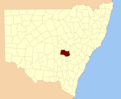
  • Ashburnham County, New South Wales — Infobox Australian cadastral name = Ashburnham state = New South Wales caption = Location in New South Wales near nw = Kennedy near n = Gordon near ne = Wellington near w = Cunningham near e = Bathurst near sw = Gipps near s = Forbes near se =… …   Wikipedia

  • Ashburnham, Massachusetts — Infobox Settlement official name = Ashburnham, Massachusetts nickname = motto = imagesize = image caption = image mapsize = 250px map caption = Location in Worcester County in Massachusetts mapsize1 = map caption1 = subdivision type = Country… …   Wikipedia

  • Ashburnham Baronets — There Ashburnham Baronetcy, of Broomham in the County of Sussex, is a title in the Baronetage of England. It was created on 15 May 1661 for Denny Ashburnham, Member of Parliament for Hastings. He was the grandson of Adam Ashburnham, Member of… …   Wikipedia

  • Ashburnham and Penhurst — Infobox UK place official name=Ashburnham and Penhurst country=England region=South East England static static image caption= area footnotes=cite web |url=http://www.eastsussexinfigures.org.uk/webview/ |title=East Sussex in Figures… …   Wikipedia

  • Ashburnham Center Historic District — Infobox nrhp | name =Orange Center Historic District nrhp type = hd caption = location= Orange, Massachusetts locmapin = Massachusetts area = architect= Howe,Lewis architecture= Mid 19th Century Revival, Late 19th And Early 20th Century American… …   Wikipedia

  • Electoral district of Ashburnham — Ashburnham was an electoral district of the Legislative Assembly in the Australian state of New South Wales, originally created in 1894 in the Parkes area and named after Ashburnham County. In 1920, with the introduction of proportional… …   Wikipedia

  • Historical U.S. Census Totals for Worcester County, Massachusetts — This article shows U.S. Census totals for Worcester County, Massachusetts, broken down by municipality, from 1900 to 2000.Like most areas of New England, Worcester County is (and has been at all times since well before the 20th century) entirely… …   Wikipedia

  • National Register of Historic Places listings in Worcester County, Massachusetts — Location of Worcester County in Massachusetts This is a list of the National Register of Historic Places listings in Worcester County, Massachusetts. It is intended to be a complete list of the properties and districts on the National Register of …   Wikipedia

  • Denny Ashburnham — For Sir Denny Ashburnham, 12th Baronet, see Ashburnham Baronets. Sir Denny Ashburnham, 1st Baronet DL, JP (d. 11 December 1697)[1] was an English politician. Contents 1 Background 2 Career …   Wikipedia

  • Earl of Ashburnham — The title Baron Ashburnham (pronounced Ash burn am ), of Ashburnham in the County of Sussex, was created in the Peerage of England in 1689 for John Ashburnham, grandson of the John Ashburnham who assisted King Charles I to escape from Oxford and… …   Wikipedia

Share the article and excerpts

Direct link
Do a right-click on the link above
and select “Copy Link”