Kilfera County

Kilfera County
Kilfera
New South Wales
Kilfera NSW.PNG
Location in New South Wales
Lands administrative divisions around Kilfera
Perry Manara Waljeers
Wentworth Kilfera Waljeers
Taila Caira Waljeers

Kilfera County is one of the 141 Cadastral divisions of New South Wales. Hatfield is located there.

Kilfera County was named after the nearby Kilfera Station.[1]

Parishes within this county

A full list of parishes found within this county; their current LGA and mapping coordinates to the approximate centre of each location is as follows:

Parish LGA Coordinates
Bidura Balranald Shire Council unknown
Bomarthong Balranald Shire Council 33°46′03″S 144°03′43″E / 33.7675°S 144.06194°E / -33.7675; 144.06194 (Bomarthong)
Chnowa Balranald Shire Council 33°52′34″S 143°42′48″E / 33.87611°S 143.71333°E / -33.87611; 143.71333 (Chnowa)
Culpaterong Balranald Shire Council 33°48′25″S 143°52′57″E / 33.80694°S 143.8825°E / -33.80694; 143.8825 (Culpaterong)
Juanbung Balranald Shire Council 33°58′59″S 143°44′04″E / 33.98306°S 143.73444°E / -33.98306; 143.73444 (Juanbung)
Magenta Balranald Shire Council 33°47′52″S 143°29′50″E / 33.79778°S 143.49722°E / -33.79778; 143.49722 (Magenta)
Sahara East Balranald Shire Council 34°04′39″S 144°01′17″E / 34.0775°S 144.02139°E / -34.0775; 144.02139 (Sahara East)
Sahara Balranald Shire Council 33°57′34″S 143°52′12″E / 33.95944°S 143.87°E / -33.95944; 143.87 (Sahara)
Solferino Balranald Shire Council 33°47′51″S 143°17′47″E / 33.7975°S 143.29639°E / -33.7975; 143.29639 (Solferino)
Tankie Balranald Shire Council 33°37′24″S 143°19′58″E / 33.62333°S 143.33278°E / -33.62333; 143.33278 (Tankie)
Willilbah East Balranald Shire Council 33°57′28″S 143°34′06″E / 33.95778°S 143.56833°E / -33.95778; 143.56833 (Willilbah East)
Willilbah Balranald Shire Council unknown
Woolpagerie Balranald Shire Council 33°42′46″S 143°32′32″E / 33.71278°S 143.54222°E / -33.71278; 143.54222 (Willilbah)
Yelkeer North Balranald Shire Council 33°44′46″S 143°53′33″E / 33.74611°S 143.8925°E / -33.74611; 143.8925 (Yelkeer North)
Yhoul Balranald Shire Council unknown

References

  1. ^ Geographical Names Board of NSW

Wikimedia Foundation. 2010.

Игры ⚽ Поможем написать курсовую

Look at other dictionaries:

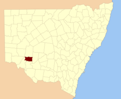
  • Kilfera County, New South Wales — Infobox Australian cadastral name = Kilfera state = New South Wales caption = Location in New South Wales near nw = Perry near n = Manara near ne = Waljeers near e = Waljeers near se = Waljeers near s = Caira near sw = Taila near w =… …   Wikipedia

  • Caira County — Map of all coordinates from Google Map of all coordinates from Bing Export all coordinates as KML …   Wikipedia

  • Manara County — Map of all coordinates from Google Map of all coordinates from Bing Export all coordinates as KML …   Wikipedia

  • Irrara County — Map of all coordinates from Google Map of all coordinates from Bing Export all coordinates as KML …   Wikipedia

  • Perry County, New South Wales — Infobox Australian cadastral name = Perry state = New South Wales caption = Location in New South Wales near nw = Menindee near n = Livingstone near ne = Manara near e = Manara near se = Kilfera near s = Wentworth near sw = Wentworth near w =… …   Wikipedia

  • Caira County, New South Wales — Infobox Australian cadastral name = Caira state = New South Wales caption = Location in New South Wales near nw = Taila near n = Kilfera near ne = Waljeers near e = Waradgery near se = Wakool near s = Wakool near sw = Tatchera (Vic) near w =… …   Wikipedia

  • Waljeers County, New South Wales — Infobox Australian cadastral name = Waljeers state = New South Wales caption = Location in New South Wales near nw = Manara near n = Mossgiel near ne = Mossgiel near e = Franklin near se = Nicholson near s = Waradgery near sw = Caira near w =… …   Wikipedia

  • Taila County, New South Wales — Infobox Australian cadastral name = Taila state = New South Wales caption = Location in New South Wales near nw = Wentworth near n = Perry near ne = Kilfera near e = Caira near se = Caira near s = Tatchera (Vic) near sw = Karkarooc (Vic) near w …   Wikipedia

  • Manara County, New South Wales — Infobox Australian cadastral name = Manara state = New South Wales caption = Location in New South Wales near nw = Livingstone near n = Woore near ne = Mossgiel near e = Mossgiel near se = Waljeers near s = Kilfera near sw = Wentworth near w =… …   Wikipedia

  • Taila County — Map of all coordinates from Google Map of all coordinates from Bing Export all coordinates as KML …   Wikipedia

Share the article and excerpts

Direct link
Do a right-click on the link above
and select “Copy Link”