- National Park Service Route 615
-
County Route 615

Route information Length: 1.28 mi[1] (2.06 km)
(Sussex County Route 615 portion only)Major junctions South end: Kuhn Road in Sandyston Township North end:  CR 640 in Sandyston
(formerly CR 560 in Sandyston)
Highway system County routes in New Jersey
500-series • County routes in Sussex County←  CR 614
CR 616  →
→County Route 615 is a short county highway in Sussex County, New Jersey. It is 1.28 miles (2.06 km) long from the intersection of Sandyston-Flatbrookville Road, Bridge Road, and Walpack Road to the intersection of Kuhn Road, Bevans Road, and Ennis Road, entirely within Sandyston Township. Official maps from both the New Jersey Department of Transportation and Sussex County list the termini of the route at the above points,[1][2], but some maps suggest the route is much longer, extending as far as County Route 560 in the north, and as far as the Warren County line on Old Mine Road in the south.[3] Sussex County Route 615 is, stated by the New Jersey Department of Transportation as being 1.28 miles (2.06 km), stretching from Bridge Road in Peters Valley (formerly Bevans) to Sussex CR 640 in Sandyston Township. Route 615 south of that is maintained by the National Park Service as it travels through the Delaware Water Gap National Recreation Area for 11 miles (18 km). The section is known as National Park Service Route 615.
Contents
Route description
National Park Service Route 615
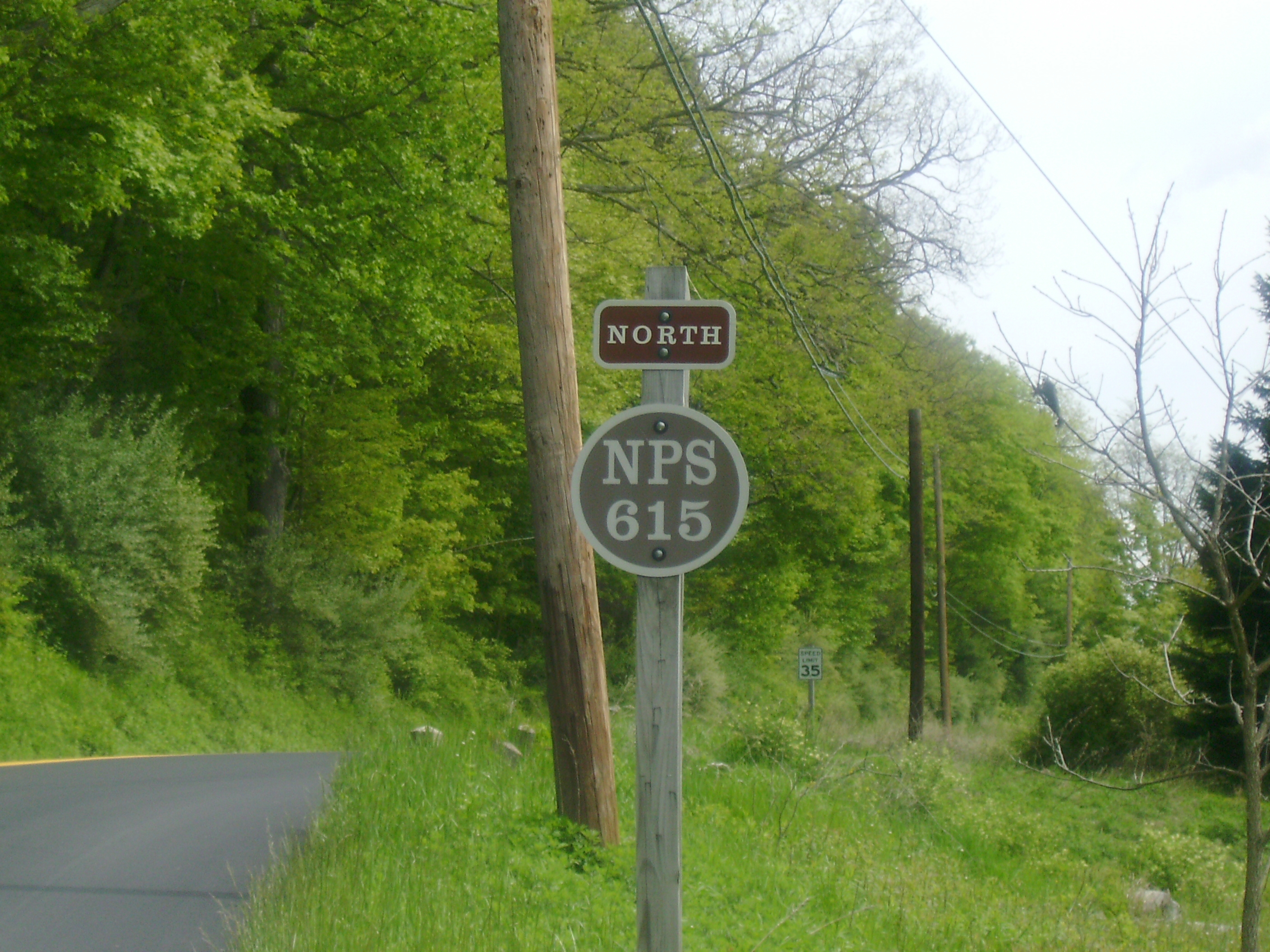
 National Park Service Route 615 heaing to the north in Walpack Center
National Park Service Route 615 begins at the Warren and Sussex County line south of Flatbrookville, New Jersey. Route 615 heads northward through the Delaware Water Gap National Recreation Area along the alignment of the Old Mine Road until the intersection with Flatbrook-Stillwater Road, where the highway heads to the north. The route soon enters the small community of Flatbrookville, New Jersey (now maintained by the National Park Service), winding through woodlands as a two-lane asphalt highway. A short distance later, Route 615 cross the Flat Brook and turn to the northeast along Walpack Road, paralleling the Flat Brook for several miles. Eventually, the Flat Brook recedes to the southeast, and the highway makes a curve to the northeast through the rural farmlands for several miles. Soon the Flat Brook does return along Route 615 and intersecting with Haneys Mill Road, a dirt road, where the highway turns further northeast along Walpack. The highway continues down the Flat Brook Valley, passing a local RV park before heading northbound through woodlands, where it curves to the north.
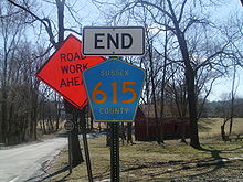 Signage at the southern terminus of Sussex County Route 615 in Peters Valley. The first reassurance shield as NPS-615 southbound is visible behind it
At the intersection with Pompey Road, Route 615 turns along Sandyston-Flatbrookville Road, passing the Walpack Inn and another RV park before entering the community of Walpack Center. In Walpack Center, Route 615 passes the nearby Ranger Station and enters the small community, passing the post office at the intersection with Main Street. After leaving Walpack Center, the highway continues northward through fields and sparse housing for several miles. Soon, the ROW of Fish & Game Road merges in with Route 615, where the route turns to the northeast and east. At the intersection with Bridge Road, National Park Service Route 615 turns to the north and heads through forestry before passing nearby houses. At that point, National Park Service Route 615 enters the community of Peters Valley (formerly Bevans), where the maintenance of Route 615 turns over to Sussex County at Kuhn Road.[4]
Sussex County Route 615
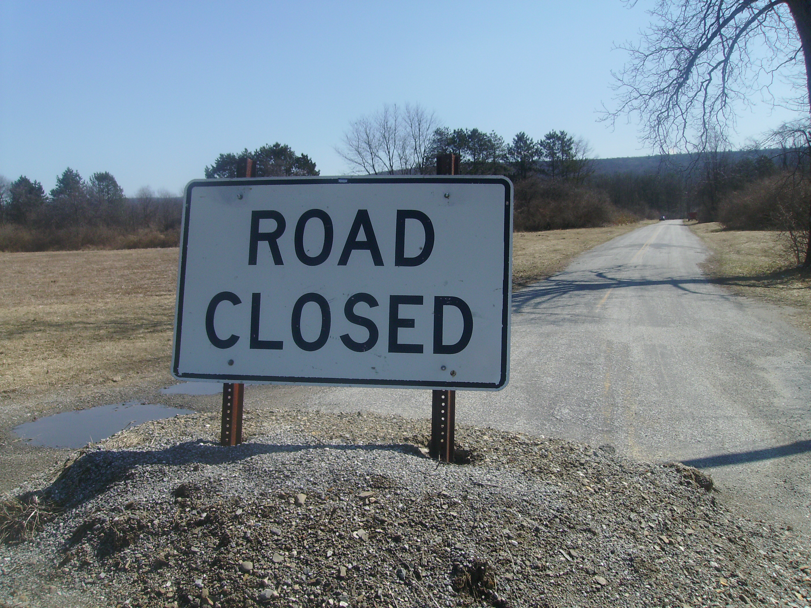
 Route 615's abandoned portion of Ennis Road at County Route 615
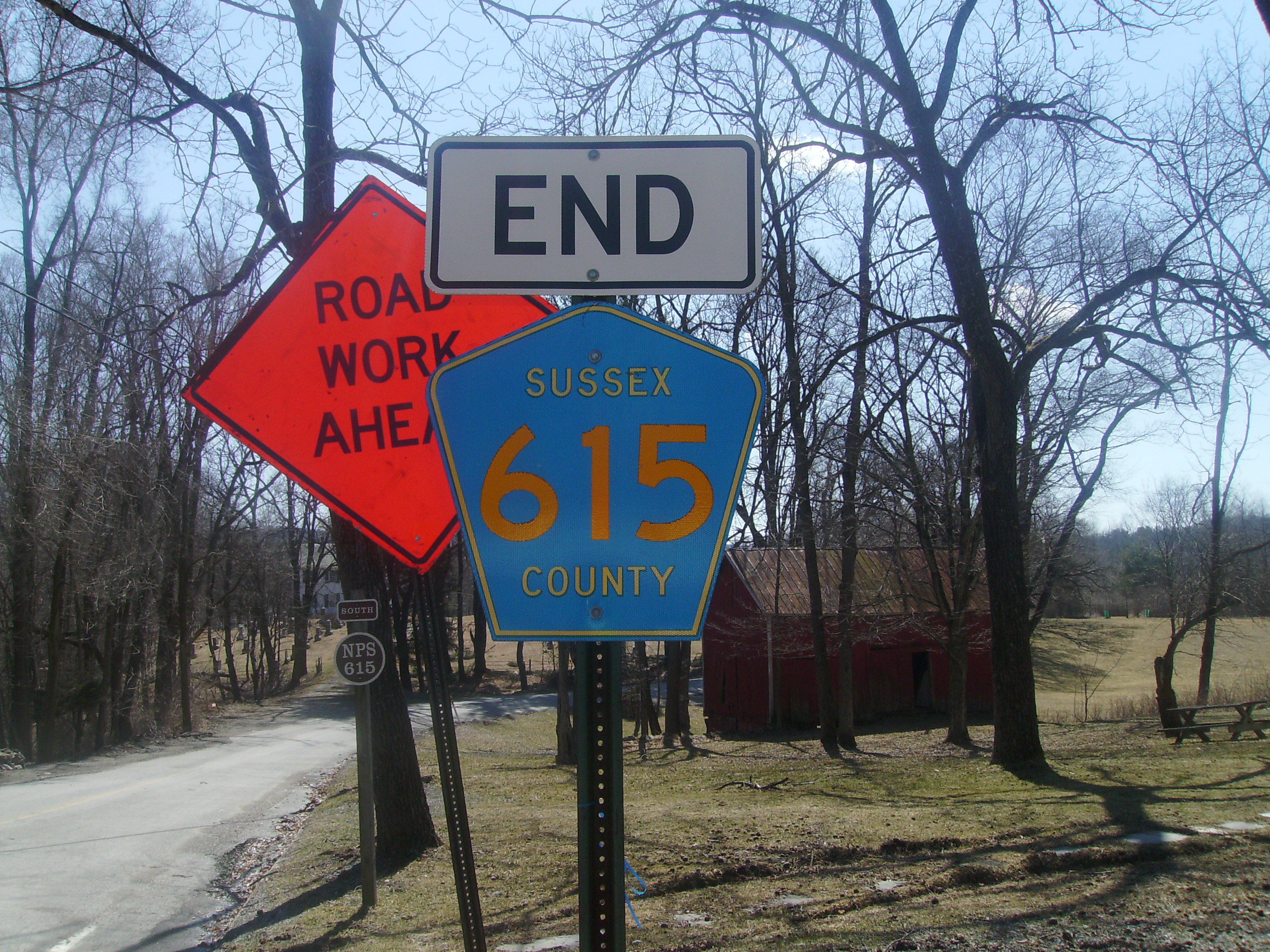
At the intersection with Kuhn Road and Walpack Road North, Route 615 changes to the northeast along Kuhn Road as Sussex County Route 615. The highway continue northeastward through Peters Valley, a small art-based community before heading northward through the local police archery and reaching the site of a trail, where Route 615 turns to the east. The highway turns eastward along Kuhn Road until the intersection with County Route 640 (Bevans Road), where Route 615 officially ends.[1]
However, until 2009, signage continued along Ennis Road, a two concrete lane, closed off portion of Route 615 through the ruralmost parts of Sandyston Township.[5] The alignment continued to the southeast, crossing through farmland until entering forestry, where it bended several times until reaching a concrete parking lot. A short distance later, the roadway ended in shrubbery and at a guard rail due to the lack of bridge over a stream. On the other side of the stream, the former alignment of County Route 615 (Ennis Road) continues to the northeast, passing through forestry and fields, where there are several dirt roads. The route continued northward until entering fields near a county maintenance department before intersecting with the County Route 560 (Tuttles Corner Road).[6]
History
Route 615 follows the alignment of the Columbia and Walpack Turnpike through most of its alignment. The original turnpike was chartered in 1819 by the New Jersey State Legislature to run from the community of Columbia to Walpack Center by a vote of 43–2.[7][8] The Columbia and Walpack Turnpike was originally constructed in 1832, which helped locals develop the communities of Millbrook and Flatbrookville. However, both communities dwindled by 1910, and as of 2009, both communities are used as little tourist attractions.[9] Although the local commnunities dropped, the Columbia and Walpack Turnpike remained, and due to problems with waterbeds, was realigned during the 1950s. However, this also eliminated the crossroads at the heart of Millbrook and the nearby automobile traffic had already used the Old Mine Road to bypass Millbrook. The former alignment of the Columbia and Walpack is now just a dirt pedestrian path.[10]
Major intersections
The entire route is in Sussex County.
Location Mile[1] Destinations Notes Flatbrookville 0.00 Warren County Route 606 Warren / Sussex county line Walpack Township Main Street Peters Valley Community of Peters Valley - Begin Sussex CR 615 NB / NPS-615 SB Signage at the intersection with Kuhn Road and the Straight Line Diagram do not match for the Southern terminus Peters Valley 0.58 Kuhn Road, Walpack Road Sandyston Township 1.28 CR 640 (Bevans Road / Ennis Road)Northern terminus of County Route 615. Ennis Road continues the ROW 1.000 mi = 1.609 km; 1.000 km = 0.621 mi See also
 U.S. Roads portal
 New Jersey portal
References
- ^ a b c d "County Route 615 Straight Line Diagram". Ewing, New Jersey: New Jersey Department of Transportation. 2009. http://www.state.nj.us/transportation/refdata/sldiag/19000615__-.pdf. Retrieved 14 January 2010.
- ^ Sussex County, New Jersey (2007). Sussex County Road Map (Map). Cartography by Sussex County, New Jersey. http://www.sussex.nj.us/Cit-e-Access/webpage.cfm?TID=7&TPID=2423. Retrieved January 14, 2010.
- ^ Google Maps (2007). Overview map of Extended CR 615 (Map). Cartography by NAVTEQ Inc.. http://maps.google.com/maps?hl=en&rlz=1T4ADBF_enUS232US232&q=from:+Millbrook+Rd/Old+Mine+Rd+%4041.073206,+-74.963684+to:+CR-615/Kuhn+Rd+%4041.201320,+-74.842120&um=1&ie=UTF-8&sa=N&tab=il. Retrieved January 14, 2010.
- ^ Microsoft. Map of Overview map of National Park Service Route 615 – Bing Maps (Map). Cartography by NavTEQ, Inc. http://www.maps.bing.com/maps/?FORM=Z9LH8#JmNwPTQxLjEzODU5NDE2OTE2OTY2NH4tNzQuOTExNzAzNzEzMjM4MjImbHZsPTExJnN0eT1yJnJ0cD1wb3MuNDEuMDg5NjEwMTU5Mzk3MTI1Xy03NC45NjA4NTk0MTc5MTUzNF9uZWFyJTIwQ1ItNjE1JTIwJTI2JTIwTWlsbGJyb29rJTIwUmQlMkMlMjBOZXclMjBKZXJzZXklMjAwNzg4MSUyQyUyMFVuaXRlZCUyMFN0YXRlc19fX2FffnBvcy40MS4xNDc0MTg0NjkxOTA2Xy03NC44OTMzODg0NTAxNDU3Ml9uZWFyJTIwOTIlMjBTYW5keXN0b24tRmxhdGJyb29rdmlsbGUlMjBSZCUyQyUyME5ldyUyMEplcnNleSUyMDA3ODgxJTJDJTIwVW5pdGVkJTIwU3RhdGVzX19fYV9+cG9zLjQxLjE5NjIwMDQ3NTA5NjdfLTc0Ljg1MDkyNTcyODY3ODdfX19fYV8mcnRvcD0wfjB+MH4=. Retrieved January 14,2009.
- ^ Google, Inc. Google Maps – Sussex County Route 615 at County Route 560 (Map). Cartography by Google, Inc. http://maps.google.com/maps?f=q&source=s_q&hl=en&geocode=&q=Layton+NJ&sll=37.0625,-95.677068&sspn=30.957823,56.162109&ie=UTF8&hq=&hnear=Layton,+Sussex,+New+Jersey&ll=41.200292,-74.819684&spn=0.007168,0.021887&z=16&layer=c&cbll=41.200821,-74.819638&panoid=nHm7oE18oaoh5yePUJ4slQ&cbp=12,340.45,,0,5. Retrieved January 14, 2010.
- ^ Microsoft. Map of Overview map of County Route 615 – Bing Maps (Map). Cartography by NavTEQ, Inc. http://www.maps.bing.com/maps/?FORM=Z9LH8#JmNwPTQxLjE0MTU3OTQ2NzgwMzI0fi03NC44OTYyNTQ4NTk4NjQ3Jmx2bD0xMSZzdHk9aCZydHA9cG9zLjQxLjA4OTYxMDE1OTM5NzEyNV8tNzQuOTYwODU5NDE3OTE1MzRfbmVhciUyMENSLTYxNSUyMCUyNiUyME1pbGxicm9vayUyMFJkJTJDJTIwTmV3JTIwSmVyc2V5JTIwMDc4ODElMkMlMjBVbml0ZWQlMjBTdGF0ZXNfX19hX35wb3MuNDEuMTQ3NDE4NDY5MTkwNl8tNzQuODkzMzg4NDUwMTQ1NzJfbmVhciUyMDkyJTIwU2FuZHlzdG9uLUZsYXRicm9va3ZpbGxlJTIwUmQlMkMlMjBOZXclMjBKZXJzZXklMjAwNzg4MSUyQyUyMFVuaXRlZCUyMFN0YXRlc19fX2FffnBvcy40MS4xOTYyMDA0NzUwOTY3Xy03NC44NTA5MjU3Mjg2Nzg3X25lYXIlMjBLdWhuJTIwUmQlMkMlMjBMYXl0b24lMkMlMjBOZXclMjBKZXJzZXklMjAwNzg1MSUyQyUyMFVuaXRlZCUyMFN0YXRlc19fX2FffnBvcy40MS4yMDA5MzEyMjEyNDY3Ml8tNzQuODE5NDgxNTIxODQ0ODZfX19fYV8mcnRvcD0wfjB+MH4=. Retrieved January 14, 2010.
- ^ Kelly-Bly, Brianne (2009). "Chapter 11". Morris County, New Jersey: Ancestry.com. http://www.rootsweb.ancestry.com/~njmorris/munsellhistory/h-chpt11.htm. Retrieved 14 January 2010.
- ^ "Index of colonial and state laws of New Jersey". Trenton, New Jersey: New Jersey State Legislature. 1903. http://books.google.com/books?id=jZgZAAAAYAAJ&pg=PA1079&dq=Columbia+and+Walpack+Turnpike&ei=pXBPS_KwPKDONMGfvJgN&cd=4#v=onepage&q=Columbia%20and%20Walpack%20Turnpike&f=false. Retrieved 14 January 2010.
- ^ Kopczynski, Susan (2009). "A Ride Down Old Mine Road Part II: Millbrook Village and Flatbrookville NJ". Millbrook, New Jersey: National Park Service. pp. 2. http://www.nps.gov/dewa/historyculture/upload/cmsstgOMR2MV.pdf. Retrieved 14 January 2010.
- ^ "Millbrook Village". Peters Valley, New Jersey: National Park Service. 2010. http://www.nps.gov/DEWA/planyourvisit/upload/sb2MV.pdf. Retrieved 14 January 2010.
Categories:- County routes in New Jersey
- Transportation in Sussex County, New Jersey


Wikimedia Foundation. 2010.