Morfa Dyffryn

Morfa Dyffryn

Morfa Dyffryn beach is on the west coast of Wales, between Barmouth and Harlech in Gwynedd. This sandy beach is several kilometres long and is chiefly known for having an officially recognised naturist area, one kilometre in length. The beach is very clean and is also known for regular sightings of dolphins.

The nearest settlements are the villages of Dyffryn Ardudwy and Llanbedr where several camp and caravan sites and guest-houses are available.

Naturism at Morfa Dyffryn

Official sign in Welsh and English showing the designated naturist space

Naturism has been practised at Morfa Dyffryn since the late 1930s. The beach can attract several hundred naturists in summer during fine weather - despite which, it is rarely crowded. Most visitors come from North Wales and North West England, although visitors from mainland Europe are not unknown.

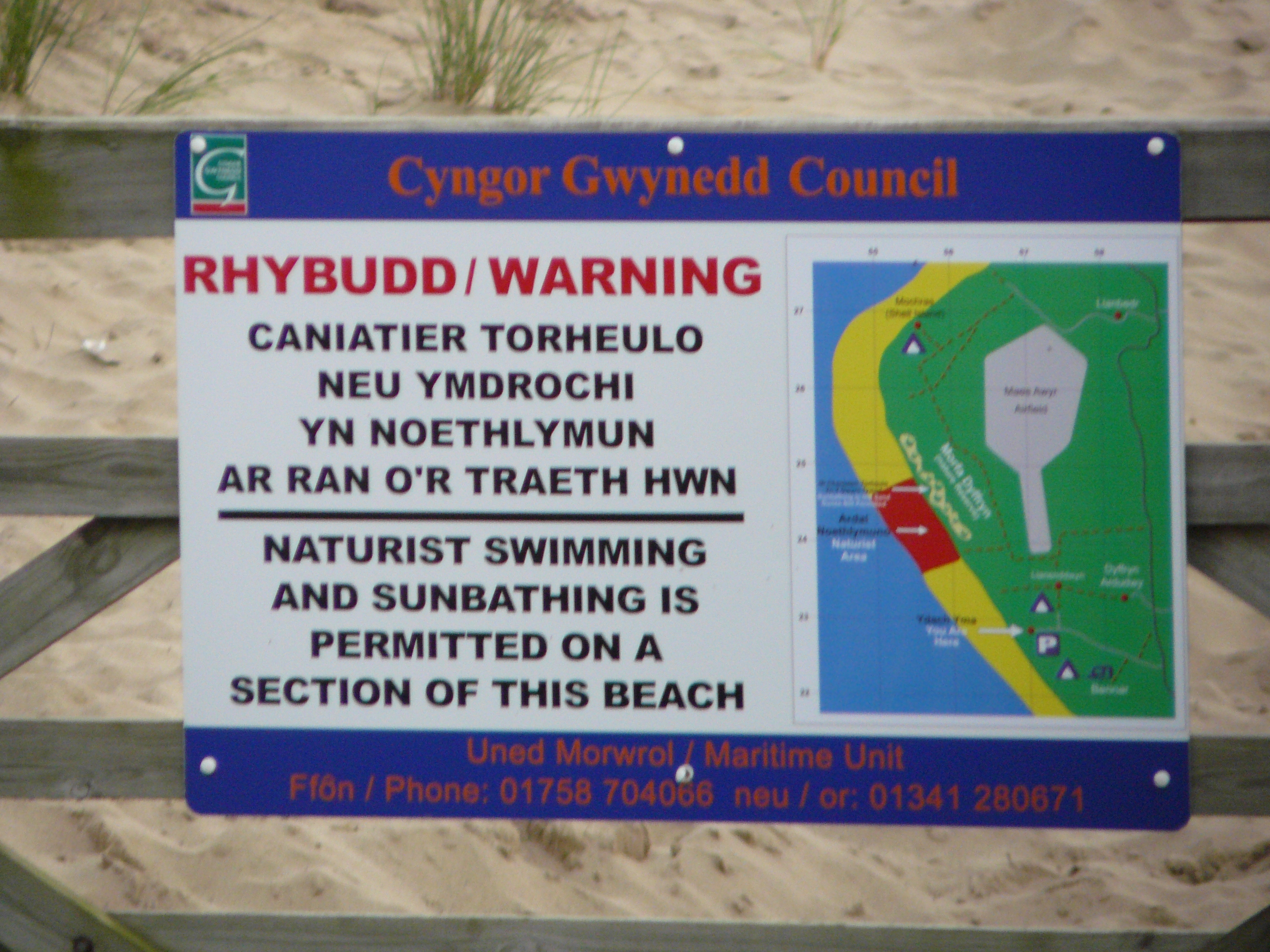
In 2000, after complaints from local residents of indecent exposure on other parts of beach and the access footpaths, steps were taken to designate a clearly marked 1 kilometre length of the beach as officially naturist. Although the official designation was resisted by some local residents, complaints of indecent exposure and related behaviour have markedly decreased since 2000. The naturist section of the beach is now clearly marked by signs at both ends. Some naturists complain that the official section is too small - the traditional naturist area was 1,6km (1 mile) in length.

Another complaint by naturists relates to the ban on naturist sunbathing in the sand dunes. Traditionally, most families and heterosexual couples have sunbathed on the beach while most gay men and many single heterosexual men have sunbathed on the dunes. This situation persists, despite the new rules. Occasional patrols by the Police or Beach Patrol take place, and usually result in sunbathers being instructed to move down from the dunes onto the beach.

The naturist section of the beach is up to 30 minutes' walk from the nearest car parks. It is essential to bring plenty of drinking water and sun-cream, especially during the hottest part of the year.

External links

Coordinates: 52°47′56″N 4°08′35″W / 52.799°N 4.143°W / 52.799; -4.143


Wikimedia Foundation. 2010.

Игры ⚽ Нужно решить контрольную?

Look at other dictionaries:

  • Dyffryn Ardudwy railway station — Dyffryn Ardudwy Location Place …   Wikipedia

  • Morfa Harlech sand dunes — Morfa Harlech (grid reference SH571337) is an extensive dune system stretching northwards from the town of Harlech in north Wales. The dunes cover some 6 km², of which an area of about 1.5 km² in the middle has been afforested with… …   Wikipedia

  • Dyffryn Banw F.C. — Dyffryn Banw Full name Dyffryn Banw Football Club Ground Cae Morfa Llangadfan Chairman John Gittings …   Wikipedia

  • List of Sites of Special Scientific Interest in East Gwynedd — This is a list of the Sites of Special Scientific Interest (SSSIs) in the East Gwynedd Area of Search; for western Gwynedd see List of SSSIs in West Gwynedd. For SSSIs elsewhere in Wales, see List of SSSIs by Area of Search.* Aber Afon Conwy *… …   Wikipedia

  • List of Special Areas of Conservation in Wales — The following is a list of Special Areas of Conservation in Wales.* Aberbargoed Grasslands * Afon Eden – Cors Goch Trawsfynydd * Afon Gwyrfai a Llyn Cwellyn * Afon Teifi/ River Teifi * Afon Tywi/ River Tywi * Afonydd Cleddau/ Cleddau Rivers *… …   Wikipedia

  • Cambrian Line — The Cambrian Line is a railway from Shrewsbury (in Shropshire, England) to Welshpool, Aberystwyth and Pwllheli. The railway runs first through the central part of Wales and then along the coast of Cardigan Bay. The railway is scenic, with parts… …   Wikipedia

  • List of Nature Conservation Review sites — The following is a list of sites listed in Derek Ratcliffe s 1979 book A Nature Conservation Review . The headings, subheadings, site codes and site names are the same as those used in the original work.Coastlandsoutheast Englandouth west… …   Wikipedia

  • Shell Island (Wales) — infobox UK place country = Wales welsh name= constituency welsh assembly= latitude= 52.81665 longitude= 4.14997 official name= Shell Island population= unitary wales= Gwynedd lieutenancy wales= Gwynedd constituency westminster= post town=… …   Wikipedia

  • List of national nature reserves in Wales — National Nature Reserves in Wales are administered by the Countryside Council for Wales. There are 67 reserves. Contents 1 List of national nature reserves 1.1 North Wales 1.2 Isle of Anglesey 1.3 …   Wikipedia

  • Llanbedr — infobox UK place country = Wales welsh name= constituency welsh assembly= Dwyfor Meirionnydd map type= latitude= 52.82011 longitude= 4.10137 official name= Llanbedr unitary wales= Gwynedd lieutenancy wales= Gwynedd constituency westminster=… …   Wikipedia

Share the article and excerpts

Direct link
Do a right-click on the link above
and select “Copy Link”