- Dekemhare
-
Dekemhare
ደቀምሓረ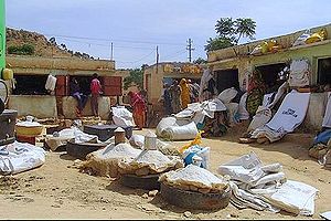 Location in Eritrea
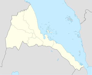
 Dekemhare
Coordinates: 15°4′N 39°2′E / 15.067°N 39.033°E Country  Eritrea
Region Debub District Dekemhare District Dekemhare (Tigrinya: ደቀምሓረ) is a town in Eritrea, lying south east of Asmara. Developed by the Italians as an industrial centre, it became known for its vineyards but was largely destroyed in the Eritrean War of Independence.
History
 Street scene in Dekemhare
Following their invasion in 1935, Dekemhare was originally intended by the Italians to be the industrial center and transport hub of Eritrea. The town was one of the primary agricultural areas for the colonialists, where they grew grapes in their vineyards for wine. Agricultural produce was not limited to grapes: many other fruits and vegetables were grown as well. The Red Sea General Mills, a biscuit factory and the Dekemhare pasta factory are examples of the last remnants of the extensive agricultural and light industry once found in Dekemhare.
The northern part of Dekemhare was where the native population lived during the colonial period. It was the bustling heart of the town, with its shops, boutiques, barbers, bus station and the old market. To the south of the city park , the cinema and the administration buildings, lie the former Italian apartment buildings, where grapes still adorn many balconies.
Dekemhare was the scene of the first major military actions of the Eritrean liberation forces in December 1962, after Ethiopia's annexation of Eritrea and suffered through several skirmishes and offensives during the last major battle of the war of liberation that began at Dekemhare on 1991-05-19.
Coordinates: 15°4′N 39°2′E / 15.067°N 39.033°E
Categories:- Dekemhare
- Debub Region
- Populated places in Eritrea
- Eritrea geography stubs


Wikimedia Foundation. 2010.