- Ballymoe
Infobox Irish Place
name = Ballymoe
gaeilge = Béal Átha Mó
crest
motto =
map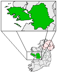
pin coords = left: 137px; top: 11px
north coord = 53.7 | west coord = 8.4667 | irish grid = M692723
area = | elevation = 80m
province =Connacht
county =County Galway
town pop = - | rural pop = 431
census yr = 2002
web = |Ballymoe ( _ga. Béal Átha Mó) is a
village inCounty Galway , Ireland. Ballymoe is situated on the western side of theRiver Suck that separates counties Galway and Roscommon. The N60national secondary road meets the R360regional road in the centre of the village.History
The name Ballymoe is derived from a fort which was built by Queen Maeve of Connaught, under the order of Mogh. The fort and village would later become known as Átha Mogh Mór and Béal Átha Mogh. The town is now the center of a small rural area involved in scale mixed farming. Raised
bog s, forts and a mass rock from penal times are features of Ballymoe today. [ [http://www.irelandwest.ie/content.asp?id=63 Ireland West] retrieved 23 February 2007]People
*
Éamonn Ceannt , one of the leaders of theEaster Rising and seven signatories of theProclamation of the Irish Republic was born in the police barracks in Ballymoe where his father James Kent, an officer in the Royal Irish Constabulary was stationed. TheGarda barracks in the town today is named in his honour. [ [http://www.nli.ie/1916/1916_main.html National Library of Ireland - 1916 Exibition] , ]
*It is the birthplace of Fr.Edward J. Flanagan , founder ofBoys Town, Nebraska .Transport
Ballymoe railway station opened on
1 March 1861 , but finally closed on17 June 1963 . [cite web | title=Ballymoe station | work=Railscot - Irish Railways | url=http://www.railscot.co.uk/Ireland/Irish_railways.pdf | accessdate=2007-09-11]ee also
*
List of towns in the Republic of Ireland References
Wikimedia Foundation. 2010.