Ballywilliam

Ballywilliam

Infobox Irish Place
name = Ballywilliam
gaeilge = Baile Liam
motto =
map

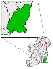
pin coords = left: 35px; top: 66px
north coord = 52.4530 | west coord = 6.8652
area = | elevation = 88m (288.7ft)
province = Leinster
county = Wexford
population = | town pop =100-200? | rural pop =100-300?
census yr = 2006
stdcode = 051
web = www.ballywilliam.com/|

Ballywilliam (Irish: "Baile Liam") is a village situated in the west of County Wexford, in Ireland. The nearest town is New Ross. The village is located on the R731 road.

History

The village once had its own Railway Station, which was closed in 1963. Ballywilliam Railway Station was the first Railway Station in Co. Wexford. It opened in 1862. [http://www.railbrit.co.uk/Ireland/Irish_railways.pdf]

Ballywilliam R.I.C. Barracks was burned during the Irish War of Independence, on 5 April 1920.

Details

Today, the village contains an Agricultural Co-op, two Pubs, and a Garda Station. [ [http://www.garda.ie/statlinks/wexford.html Garda Station telephone numbers Wexford/Wicklow Division ] ] The Garda Station is generally empty, though still used, and is operated by Gardaí from New Ross Garda station. [ [http://www.irlgov.ie/debates-03/2Apr/Sect10.htm Dáil Debate - 2 April 2003 ] ] Ballywilliam also contains a Shop/Petrol Station.

] The Shop or Petrol station was destroyed by a car crash to the gasoline tanks. The Building Caught Fire and the people ran out. No one died but two received minor injuries.

References & Footnotes

The Petrol Station and shop was destroyed by a car crash. Witch the shop/petrol station caught fire. Zero fatalities some minor injuries.


Wikimedia Foundation. 2010.

Игры ⚽ Поможем написать курсовую

Look at other dictionaries:

  • Балливильям — Деревня Ирландии Балливильям англ. Ballywilliam, ирл. Baile Liam Страна …   Википедия

  • County Wexford — Contae Loch Garman Coat of arms …   Wikipedia

  • Gorey — This article is about the town in Ireland. For the artist, see Edward Gorey. For the town in Jersey, see Gorey, Jersey. Gorey Guaire   Town   …   Wikipedia

  • Monamolin — Village square, Manomolin Monamolin or Monamoling (Irish: Muine Moling) is a small rural village in County Wexford, Ireland, about 11 km (6.8 mi) south of the town of Gorey. Monamolin (in the parish of the same name) …   Wikipedia

  • Bunclody — Bun Clóidí   Town   Market Square, Bunclody …   Wikipedia

  • Regional road — Regional roads are also used in some parts of Ontario. See County Road for more information. A regional road ( ga. Bóthar Réigiúnach) in Ireland is a class of road not forming a major route (such as a national primary route or national secondary… …   Wikipedia

  • Cushinstown — is one of the largest parishes in County Wexford, Ireland. There are 3 churches in the parish: Rathgarogue, Cushinstown and Terrerath. The parish has a population of approximately 2500. There are a number of villages in the parish including… …   Wikipedia

  • Burgess GAA — Infobox GAA club club gaa = Burgess crest = irish = An Bhuirgéis county = Tipperary colours = Green and Gold grounds = Kilcolman founded = 1884 honours = pattern la= |pattern b= yellowhoops|pattern ra= leftarm=28AE7B |body=28AE7B… …   Wikipedia

  • Courtown — Baile na Cúirte   Village   Courtown centre …   Wikipedia

  • List of townlands in County Down — The following is a list of townlands located in County Down, Northern Ireland. NOTOC AAcre McCricket, Aghacullion, Aghandunvarran, Aghavilly, Aghlisnafin, Aghnaleck, Aghnamoira, Aghnatrisk, Aghyoghill, Angus Rock, Annacloy, Annadorn, Annaghanoon …   Wikipedia

Share the article and excerpts

Direct link
Do a right-click on the link above
and select “Copy Link”