- Sayler's Creek Battlefield
Infobox_nrhp | name =Sayler's Creek Battlefield
nrhp_type = nhl
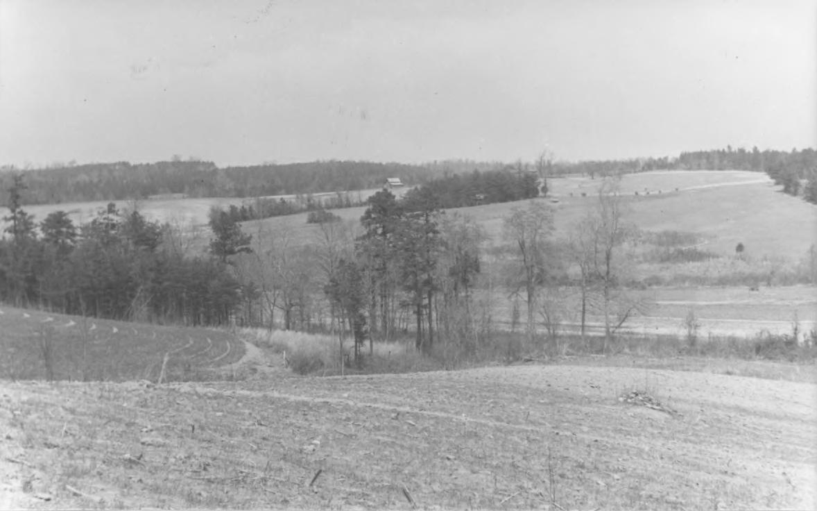
caption = View from Ewell's right across Sayler's Creek (Hillsman House in background), 1936 NPS photo
nearest_city=Farmville, Virginia
locmapin = Virginia
area =convert|1022|acre|km2
built =
architect= Unknown
architecture= Colonial
designated=February 4 ,1985 cite web|url=http://tps.cr.nps.gov/nhl/detail.cfm?ResourceId=1905&ResourceType=Site
title=Sayler's Creek Battlefield |accessdate=2008-04-23|work=National Historic Landmark summary listing|publisher=National Park Service]
added =February 04 ,1985 cite web|url=http://www.nr.nps.gov/|title=National Register Information System|date=2007-01-23|work=National Register of Historic Places|publisher=National Park Service]
governing_body = State
refnum=85002436Sayler's Creek Battlefield near
Farmville, Virginia was the site of theBattle of Sayler's Creek of theAmerican Civil War .Robert E. Lee 's army was retreating from the Richmond to Petersburg line. Here, onApril 6 ,1865 , Union GeneralPhilip Sheridan cut off and beat back about a quarter of Lee's army. Eight Confederate generals surrendered, and 7,700 men were lost. This was the last major engagement of the war; Lee's surrender at Appomattox occurred three days later. A portion of the landmarked battlefield area is included inSailor's Creek Battlefield Historical State Park .The battle was composed of three separate engagements, which may be termed the Battle of Hillsman's Farm, the Battle of Marshall's Cross Roads (or Battle of Harper's Farm), and the Battle of Lockett's Farm (or Battle of Double Bridges). The Hillsman house served as a hospital for both Confederate and Union troops. Bloodstains still remain on the floor from when it served as a hospital after the battles. [ [http://www.civilwaralbum.com/misc/sayler1.htm Battle of Sayler's Creek site photos ] ] [http://scholar.lib.vt.edu/VA-news/VA-Pilot/issues/1995/vp951008/10060064.htm] The Lockett house is in its original state. The Christian house is also there.citation|title=PDFlink| [http://pdfhost.focus.nps.gov/docs/NHLS/Text/85002436.pdf National Register of Historic Places Inventory-Nomination: Sayler's Creek Battlefield] |32 KB|date=June, 1984 |author=Christopher M. Calkins |publisher=National Park Service (includes 6 maps describing the battle) and PDFlink| [http://pdfhost.focus.nps.gov/docs/NHLS/Photos/85002436.pdf "Accompanying four photos, from 1936"] |32 KB]
Areas in the NHL site include four portions of convert|800|acre|km2, convert|215|acre|km2, convert|5|acre|m2, and convert|0.6|acre|m2. These are indicated on topographical maps included in the Virginia DHR provided version of the NRHP documents.citation|title=PDFlink| [http://www.dhr.virginia.gov/registers/Cities/Hampton/004-0019_Sayler's_Creek_Battlefield_1985_Final_Nomination_NHL.pdf National Register of Historic Places Inventory-Nomination: Sayler's Creek Battlefield] |32 KB|date=June, 1984 |author=Christopher M. Calkins |publisher=National Park Service (includes 6 maps describing the battle, and topographical maps showing the four NHL site areas)] Only convert|321|acre|km2 are covered by the current state park.
It is located on Virginia Routes 617, 618, and 619 in Farmville and Burkeville, in Amelia and Prince Edward counties in Virginia. From 1865 to the area's nomination for the National Register in 1984, the area saw little development, and remained much as it was during the battles. It was declared a
National Historic Landmark in 1985.Costumed interpreters station the park throughout the year.
Living history performers are active in the park during the anniversary of the battle every April. [http://www.dcr.virginia.gov/state_parks/documents/vspguide.pdf pg.9]The land was originally named in the 1700s for a farmer named Saylor. During the Civil War, the name was changed to Sayler. Some official records called it Sailor, which is what the state of Virginia uses in its name for the related park. [ [http://www.csnavy.org/saylor,creek.htm WS_FTPcsnsaylor,creek ] ]
References
External links
* [http://www.dhr.virginia.gov/registers/Counties/Amelia/Sayler's_Creek_photo.htm Sayler's Creek Battlefield, Amelia County, one photo at Virginia DHR]
Wikimedia Foundation. 2010.