- Municipio XIX
-
Municipio XIX Country:  Italy
ItalyMunicipality:  Rome
RomeArea: 137 km² Population: 177,418 pop. density: 1,295 km² President: Alfredo Milioni Website: Official site Map 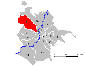
The Municipio XIX, is an administrative subdivisions of the city of Rome. It is situated to the north-west part of the municipality of Rome.
Contents
Subdivision
Municipio XIX is divided in 8 urbanisms zones:
M. XIX (Monte Mario) 19a Medaglie d'Oro 39,939 19b Primavalle 60,059 19c Ottavia 15,165 19d Santa Maria della Pietà 18,561 19e Trionfale 16,769 19f Pineto 2,080 19g Castelluccia 16,747 19h Santa Maria di Galeria 2,605 Not located 5,493 Total 177,418 The territory includes the following districts:
Q.XIII Aurelio, Q.XIV Trionfale and Q.XXVII Primavallethe following "suburbi":
S.X Trionfale and S.XI Della Vittoriaand the following zones:
Z.XLVIII Casalotti, Z.XLIX Santa Maria di Galeria, Z.L Ottavia, Z.LI La Storta and Z.LIII Tomba di Nerone.The "Municipio" includes the following urban areas:
Balduina, La Lucchina, Monte Mario, Palmarola, Pineta Sacchetti, Proba Pretonia, Quartaccio, Selva Candida, Selva Nera, Tragliatella, Torresina e Torrevecchia.Politics
The list of the Presidents of the Municipio XIII since 2001:
Coalition President 2008 center-right Alfredo Milioni 2006 center-left Fabio Lazzara 2001 center-left Fabio Lazzara Resources
In the "Municipio" there are a lot of green areas, the principal are: the Natural Reserve of the Insugherata, the urban Regional Park of the Pineto, the Natural Monument "Quarto degli Ebrei - Tenuta di Mazzalupetto".
There are the Agostino Gemelli Hospital and the San Filippo Neri Hospital, two of the most important hospitals in Rome.
External links
 Media related to Municipio XIX at Wikimedia Commons
 Municipio I (List of Rioni) • Municipio II • Municipio III • Municipio IV • Municipio V • Municipio VI • Municipio VII • Municipio VIII • Municipio IX • Municipio X • Municipio XI • Municipio XII • Municipio XIII •
Municipio XIV• Municipio XV • Municipio XVI • Municipio XVII • Municipio XVIII • Municipio XIX • Municipio XX Categories:
- Municipi of Rome
- Lazio geography stubs

Wikimedia Foundation. 2010.