- New Hampshire Route 10A
-
Route 10A

Route information Length: 1.06 mi (1.71 km)
Vermont: 0.522 mi (0.840 km)[1]
New Hampshire: 0.54 mi (0.87 km)[2]Major junctions West end: 
 I-91 / US 5 near Norwich, Vt.
East end:  NH 10 in Hanover, N.H.
Highway system New Hampshire Routes
State highways in Vermont← NH 10NH NH 11  →
→←  VT 10
VT 10VT VT 11  →
→Route 10A (New Hampshire Route 10A (NH 10A) and Vermont Route 10A (VT 10A)) is a 1-mile (1.6 km) long highway in the states of Vermont and New Hampshire. The route begins at New Hampshire Route 10 in Hanover, New Hampshire and ends at Interstate 91 and U.S. Route 5 in the town of Norwich, Vermont. Route 10A is a spur route of New Hampshire Route 10 and its extension in Vermont is not related to Vermont Route 10.
Contents
Route description
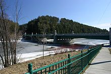 Route 10A crosses the Connecticut River over the Ledyard Bridge
Route 10A begins at the interchange where Interstate 91 and U.S. Route 5 meet south of the town of Norwich, Vermont. From the interchange, it heads east towards the Connecticut River. It crosses the Ledyard Bridge over the river and enters Hanover, New Hampshire where it becomes West Wheelock Street. NH 10A ends at Main Street, which carries New Hampshire Route 10, in downtown Hanover. NH 10A is the shortest state highway in New Hampshire.
Junction list
State County Location Mile[1][2] Destinations Notes Vermont Windsor Norwich 0.000 I-91 south / US 50.246 I-91 northConnecticut River 0.522
0.00Ledyard Bridge New Hampshire Grafton Hanover 0.54 NH 10 (Main Street)1.000 mi = 1.609 km; 1.000 km = 0.621 mi See also
References
- ^ a b Vermont Agency of Transportation (2003). Vermont General Highway Map - Town of Norwich (Map). Lewiston inset. http://www.aot.state.vt.us/Planning/images/townmaps/Norwich.pdf. Retrieved October 3, 2010.
- ^ a b New Hampshire Department of Transportation. "NHDOT Route Log System". http://199.192.2.93/NHRouteLog/. Retrieved October 3, 2010.
Categories:- State highways in New Hampshire
- Transportation in Grafton County, New Hampshire


Wikimedia Foundation. 2010.