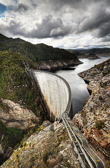
- Gordon Dam
-
Gordon Dam 
Location SW Tasmania, Australia Coordinates 42°43′50″S 145°58′35″E / 42.73056°S 145.97639°ECoordinates: 42°43′50″S 145°58′35″E / 42.73056°S 145.97639°E Opening date 1978 Owner(s) Hydro Tasmania Dam and spillways Type of dam Arch dam Height 140 m (459 ft) Length 192 m (630 ft) Base width 18 m (59 ft) Impounds Gordon River Reservoir Creates Lake Gordon Capacity 12.5 km3 (3.0 cu mi) Surface area 272 km2 (105 sq mi) Power station Type No Turbines 3 × 144 MW Installed capacity 432 MW Bridge Carries Pedestrians[1] Width 2.7 m (8.9 ft) Website
http://www.hydro.com.auThe Gordon Dam (also known as Gordon River Dam), is a double curvature arch dam on the Gordon River in Tasmania, Australia. The dam has a length of 192 m (630 ft), and a height of 140 m (459 ft),[2] making it the tallest dam in Tasmania and the fifth-tallest in Australia.[3]
Water from the dam drops 183 m (600 ft) underground into its power station, where three turbines of 144 MW generates up to 432 MW of power, covering about 13% of the electricity demand of Tasmania.[4] The first two turbines were commissioned in 1978, before the third was commissioned a decade later in 1988.[5]
The power station is fuelled by water from Lake Gordon. Water from Lake Pedder is also drawn into Lake Gordon through the McPartlans Pass Canal at 42°50′51″S 146°11′45″E / 42.8475°S 146.19583°E.
History
In 1963, the Federal Government of Australia provided a A$5 million grant to Tasmania's Hydro-Electric Commission to build the Gordon River Road from Maydena into the Gordon River area in the South West Wilderness region.[6] Construction was underway by 1964, and within three years, the Tasmanian State Parliament approved the Gordon River Power Development with little in house opposition in 1967.
The completed Gordon Dam was the only dam built on the Gordon River, despite the support of Tasmanian politicians such as Eric Reece, Robyn Gray, and others to build the Franklin Dam further downstream.
The dam was designed with Dr. Sergio Guidici as the chief engineer. He went on to be involved with the design of the Crotty Dam in the West Coast Range, one of the last significant dams created by Hydro Tasmania during its unabated dam-building era.
See also
- Franklin-Gordon Wild Rivers National Park
- List of power stations in Tasmania
- Southwest National Park
References
- ^ "Southwest National Park". http://www.discovertasmania.com/activities__and__attractions/wilderness_areas/national_parks_and_reserves/southwest_national_park.
- ^ "?". hydro.com.au. http://www.hydro.com.au/handson/grpd/gordondam.htm.[dead link]
- ^ "Australia's Highest Dams" (pdf). The Australian National Committee on Large Dams Incorporated. http://www.ancold.org.au/images/Table%20II.pdf. Retrieved 2008-04-07. "The five tallest dams listed in order of decreasing height are: Dartmouth Dam, 180m, Victoria; Thomson River Dam, 166m, Victoria; Talbingo Dam, 162m, NSW; Warragamba Dam, 142m, NSW; Gordon Dam, 140m, Tasmania"
- ^ "The Gordon Catchment". http://www.hydro.com.au/handson/grpd/.
- ^ "Engineers Australia". National Engineering Landmark explanatory pdf. http://www.engineersaustralia.org.au/shadomx/apps/fms/fmsdownload.cfm?file_uuid=F534AF76-A059-6E84-F863-484F13EB4B37&siteName=ieaust.
- ^ Thompson, Peter (1981) Power In Tasmania ACF ISBN 0858020645 pp.19
Gordon Power Development Hydroelectric Gordon Dam · Franklin Dam (cancelled)Non-hydroelectric Energy in Tasmania Hydro Bastyan • Butlers Gorge • Catagunya • Cethana • Cluny • Devils Gate • Fisher • Gordon • John Butters • Lake Echo • Lemonthyme • Liapootah • Mackintosh • Meadowbank • Paloona • Poatina • Reece • Repulse • Rowallan • Tarraleah • Trevallyn • Tungatinah • Wayatinah • WilmotWind Farms Huxley Hill • Musselroe • WoolnorthGas Tamar Valley • Bell BayMisc Companies Regulators Office of the Tasmanian Energy RegulatorHistorical Duck Reach • Lake Margaret • Moorina • WaddamanaCategories:- Reservoirs and dams in Australia
- South West Tasmania
- Arch dams
Wikimedia Foundation. 2010.


