- Fort Morgan (Alabama)
Infobox nrhp
name = Fort Morgan
nrhp_type = nhl
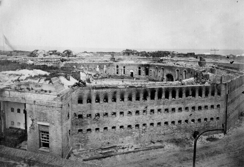
caption = Fort Morgan, Slag Point, Alabama, 1864, showing damage to the Citadel. The Citadel was a ten-sided barracks located in the center of the fort, used to house the enlisted men. The wooden roof of the Citadel caught fire during the 1864 siege, and the structure was destroyed. Postwar repair crews did not rebuild the structure, but instead razed it to the ground.
location = Western terminus of AL 180Gasque, Alabama
nearest_city =
lat_degrees =
lat_minutes =
lat_seconds =
lat_direction =
long_degrees =
long_minutes =
long_seconds =
long_direction =
area =
built =1819-1834
architect =Simon Bernard
architecture =
designated =December 19 ,1960 cite web|url=http://tps.cr.nps.gov/nhl/detail.cfm?ResourceId=70&ResourceType=Building
title=Fort Morgan |accessdate=2007-10-28|work=National Historic Landmark summary listing|publisher=National Park Service]
added =October 15 ,1966 cite web|url=http://www.nr.nps.gov/|title=National Register Information System|date=2007-01-23|work=National Register of Historic Places|publisher=National Park Service]
visitation_num =
visitation_year =
refnum = 66000146
mpsub =
governing_body = StateFort Morgan is a
fort at the mouth ofMobile Bay ,Alabama ,United States . Some regard it as "one of the finest examples of military architecture in the New World"cite web|url=http://www.archives.state.al.us/markers/ibaldwin.html
title=ADAH Historical Markers—Baldwin County: Fort Morgan |accessdate=2007-10-28|work=Texts of historical markers placed by Alabama Historical Society|publisher=Alabama Department of Archives & History]The post was named in honor of
Revolutionary War heroDaniel Morgan . Construction was completed in1834 and it was first garrisoned in March of that year.In the
American Civil War during theBattle of Mobile Bay , Union land forces besieged Fort Morgan. GeneralRichard L. Page commander of the fort was forced to surrender onAugust 23 ,1864 . Fort Morgan was designated aNational Historic Landmark in1960 .citation|title=PDFlink| [http://pdfhost.focus.nps.gov/docs/NHLS/Text/66000146.pdf National Register of Historic Places Inventory-Nomination: Fort Morgan] |641 KiB |date=October 4, 1975 |last=Schroer |first=Blanche Higgins |publisher=National Park Service and PDFlink| [http://pdfhost.focus.nps.gov/docs/NHLS/Photos/66000146.pdf Accompanying 25 or so photos, aerial, exterior and interior, from 1864, c. World War II, 1959, 1974, 1975 and 19.] |3.41 MiB ]In 2007 it was listed as "one of the nation's 10 most endangered battle sites" by the
Civil War Preservation Trust in "History Under Siege: A Guide to America's Most Endangered Civil War Battlefields"cite web|url=http://www.civilwar.org/PressReleases/PressDetail.asp?lngPressID=142
title=Civil War Preservation Trust Unveils Report on Most Endangered Battlefields |date=2007-03-13|work=Press Release |publisher=Civil War Preservation Trust]Fort Morgan is at the tip of Mobile Point, which, together with
Dauphin Island upon which Fort Gaines is situated, enclosesMobile Bay . It is at the western terminus ofState Route 180 (Alabama) .Fort Morgan, Alabama is a nearby unincorporated community on Mobile Point, named after the fort. The site is maintained by theAlabama Historical Commission .In June 2008, a 90-pound unspent Union naval shell was uncovered at the site.The shell was from a Parrott rifle installed on a U.S. Navy gunship and fired at the fort in the summer of 1864. The discovery came during excavations part of a project meant to repair cracks in the walls.
In October, 2006, the wreckage of a convert|136|ft|m|adj=on long ship, whose identity is still unknown, was uncovered by beach erosion near Fort Morgan. It was covered again by natural forces by December 2006. [ [http://www.tuscaloosanews.com/apps/pbcs.dll/article?AID=/20061203/NEWS/612030348/1027] ] In September 2008, in the aftermath of
Hurricane Ike , it was uncovered again. [ [http://www.ireport.com/docs/DOC-85854;jsessionid=67A55523FB6DE14C8FF78879B7602358] ] A marine archaeologist with the Museum of Mobile determined that it is most likely the remains of the "Monticello", a two-mastedschooner that attempted to run the U.S. Navy blockade on June 26, 1862, but ran aground and burned. It had been sailing fromHavana to Mobile. However, the U.S. Army Corps of Engineers made a determination in 2000 that the ship in question was most likely the "Rachel", a schooner built in 1919 that ran aground near Fort Morgan in 1933. [cite news | last = Busby| first = Guy| title = Ike uncovers historic ship on Baldwin County beach| work = Press-Register| date = 2008-09-19| url = http://www.al.com/news/press-register/metro.ssf?/base/news/1221815716203500.xml&coll=3| accessdate = 2008-09-19]ee also
*
List of National Historic Landmarks in Alabama References
External links
* See [http://www.cr.nps.gov/nr/twhp/wwwlps/lessons/73morgan/73morgan.htm Fort Morgan and the Battle of Mobile Bay] for a lesson on the Battle of Mobile Bay from the National Park Service's Teaching with Historic Places.
* [http://www.azaleacity.com/fortmorgan/information.htm Friends of Fort Morgan]
* [http://www.nps.gov/history/nr/twhp/wwwlps/lessons/73morgan/73morgan.htm "”Fort Morgan and the Battle of Mobile Bay”", a National Park Service Teaching with Historic Places (TwHP) lesson plan]
Wikimedia Foundation. 2010.