- Davis Mountains
-
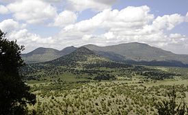
Davis Mountains Range Davis MountainsCountry United States State Texas Highest point Baldy Peak atop Mount Livermore - elevation 8,378 ft (2,554 m) - coordinates 30°38′N 104°10′W / 30.633°N 104.167°W Geology Igneous Period Paleogene For the Texas wine region around the Davis Mountains, see Texas Davis Mountains AVA.The Davis Mountains are a range of mountains in West Texas, located near Fort Davis, after which they are named. They are a popular site for camping and hiking and the region includes Fort Davis National Historic Site and Davis Mountains State Park. The historical and architectural value of the fort, along with the rugged natural beauty of the park combine to prepresent a significant destination for tourism in Texas.
Contents
Origin and geology
The mountains are of volcanic origin composed of strata associated with eruptions of the Trans-Pecos Texas volcanic field 35 million years ago.[1] The highest peak in the Davis Mountains is Mount Livermore at 8,382 feet, and is the fourth highest peak in Texas.
Conservation
Recently, the The Nature Conservancy has acquired 32,000 acres (130 km²), along with conservation easements on 33,830 acres (136.9 km²) more. This parcel is open to the public at specified times.
Facilities
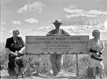
The McDonald Observatory is located on Mount Locke. It is accessed by Texas State Highway 118 which is the highest state maintained road in Texas at 6,791 feet.
External links
- Davis Mountains from the Handbook of Texas Online
- Davis Mountains and Indian Lodge - December 5, 2007 - Houston Chronicle
- Davis Mountains photographs, hosted by the Portal to Texas History
- Davis Mountains State Park - Texas Parks and Wildlife
- Davis Mountains Preserve - Nature Conservancy
- U.S. Geological Survey Geographic Names Information System: Davis Mountains
References
- ^ "40Ar/39Ar chronology and volcanology of silicic volcanism in the Davis Mountains, Trans-Pecos Texas", doi: 10.1130/0016-7606(1994)106<1359:AACAVO>2.3.CO;2 Geological Society of America Bulletin November 1994 v. 106 no. 11 p. 1359-1376, accessed September 13, 2010
Categories:- Mountain ranges of Texas
- Geography of Jeff Davis County, Texas
- Protected areas of Jeff Davis County, Texas
- Nature Conservancy preserves
- Texas geography stubs
Wikimedia Foundation. 2010.


