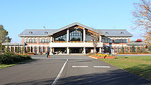
- Sapporo Satoland
-
Satoland site of the Sapporo Snow Festival in 2008

Sapporo Satoland (サッポロさとらんど Sapporo Satorando) is an amusement park located in Higashi-ku, Sapporo, Hokkaidō, Japan. Having an agricultural theme, Sapporo Satolando was opened in 1995. The official name of the Satoland is Sapporo Facility of Agricultural Experience and Interchange (札幌市農業体験交流施設 Sapporo Nōgyō Taiken Kōryū Shisetsu).
Contents
History
The Sapporo Satoland was established in 1995. Facilities have been run by a caretaker, Sato Mirai Project Group since April 1, 2006.[1] After the expansion to the west side in 2004, the total area of the Satoland was extended to about 74 ha.[2] The Sapporo Snow Festival has had three main sites in Sapporo, and the utilization of Makomanai site was suspended in 2005. The site was moved to Satoland since 2006, and huge snow slide and maze have been made during the festival. From the festival in 2009, the site was moved to the Sapporo Community Dome (Tsudome). Remains of the early Satsumon period, a prehistoric period in Hokkaidō between 9th and early 10th century, is located in the park, and the grain relics were revealed to be cultivated in the site during the Satsumon period. Agricultural activities in the Satsumon period has been unknown, and the relics from the remain in Satoland became a clue to understand the origin of agriculture in Hokkaidō prefecture.[3]
Overview
The location of the Sapporo Satoland is close to the Moerenuma Park, and food processing facility, event venues, farm, pasture, flower gardens, and park golf ground are located in the area. The free parking lot houses 1,800 vehicles.[4]
The Satoland Centre has a restaurant and meeting rooms, and the Satoland Interchange Hall has a hall, which was designed for events. Visitors can eat organic vegetables cropped in Hokkaidō at the restaurant and shops in the building.
The agricultural experience program, including butter, sausage, and ice cream making experience, has been held at the farm in the park. A bus and carriage are running around the park.
References
- ^ Satoland caretaker selection result
- ^ Welcome Sapporo
- ^ Hokkaidō Shinbun, July 5, 2007.
- ^ Satoland Information
External links
- Sapporo Satoland Homepage (Japanese)
43°07′10″N 141°24′56″E / 43.119573°N 141.415528°ECoordinates: 43°07′10″N 141°24′56″E / 43.119573°N 141.415528°E
Categories:- Higashi-ku, Sapporo
- Agriculture in Japan
- Amusement parks in Japan
Wikimedia Foundation. 2010.


