- Ohrdruf
-
This article is about the German town. For the Nazi camp, see Ohrdruf concentration camp.
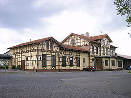
Ohrdruf Railway station 
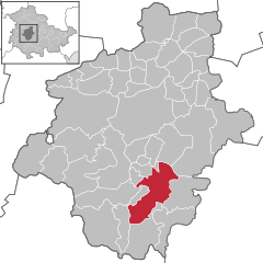
Coordinates 50°49′41″N 10°43′58″E / 50.82806°N 10.73278°ECoordinates: 50°49′41″N 10°43′58″E / 50.82806°N 10.73278°E Administration Country Germany State Thuringia District Gotha Mayor Marion Hopf Basic statistics Area 39.75 km2 (15.35 sq mi) Elevation 375 m (1230 ft) Population 5,745 (31 December 2010)[1] - Density 145 /km2 (374 /sq mi) Other information Time zone CET/CEST (UTC+1/+2) Licence plate GTH Postal code 99885 Area code 03624 Website www.ohrdruf.de Ohrdruf is a small town in the German federal state of Thuringia. It lies some 30 km southwest of Erfurt.
Contents
Medieval settling
Ohrdruf was founded in 724–726 by Saint Boniface, as the site of the first monastery in Thuringia, dedicated to Saint Michael. It was the first of several religious foundations in the town, the latest of which is the Carmelite monastery Karmel St. Elija (founded 1991).
Johann Sebastian Bach
In 1695 the orphaned Johann Sebastian Bach came to live and work at the Michaeliskirche (St Michael's church) here, under the care of his older brother Johann Christoph Bach (1671–1721). He lived in Ohrdruf from the ages of 10 to 15.
Ohrdruf toy manufacture
In the 1800s the town became a centre of toy manufacturing. The Kewpie doll was produced here from 1913. You can still find some of the old molds included in the facades of Ohrdruf buildings.
Nazi rule
The Ohrdruf death camp located here was the first Nazi concentration camp to be liberated by the American Army, on 4 April 1945.
According to a book written by the German historian Rainer Karlsch and published in 2005, Ohrdruf was one of two locations where the Nazi Diebner's team has tested its nuclear energy project. During this process, according to Karlsch, prisoners of war were killed under the supervision of the SS. This claim is not universally accepted, yet, some findings near the town support it: signs of large excavations and blocked tunnels in the nearby Jonas Valley. The remains are located right behind one of the hills next to Ohrdurf, at about the same elevation as the town, which can suggest more tunnels exits at the town side too.
It could be the same site, where the Nazis constructed at the end of World War II, with the help of slave labour, the S III Führer Headquarters, a massive underground complex of long tunnels. This was reputedly to have been a centre for a final stand against the Allies, after a retreat from Berlin. This plan did not come to fruition.[citation needed]
References
- ^ "Bevölkerung nach Gemeinden, erfüllenden Gemeinden und Verwaltungsgemeinschaften" (in German). Thüringer Landesamt für Statistik. 31 December 2010. http://www.statistik.thueringen.de/datenbank/TabAnzeige.asp?tabelle=gg000102%7C%7C.
External links
- [1] Third Reich Ruins
Towns and municipalities in Gotha (district) Aspach • Ballstädt • Bienstädt • Brüheim • Bufleben • Crawinkel • Dachwig • Döllstädt • Drei Gleichen • Ebenheim • Emleben • Emsetal • Eschenbergen • Friedrichroda • Friedrichswerth • Friemar • Fröttstädt • Georgenthal • Gierstädt • Goldbach • Gotha • Gräfenhain • Großfahner • Günthersleben-Wechmar • Haina • Herrenhof • Hochheim • Hohenkirchen • Hörselgau • Laucha • Leinatal • Luisenthal • Mechterstädt • Metebach • Molschleben • Nesse-Apfelstädt • Nottleben • Ohrdruf • Petriroda • Pferdingsleben • Remstädt • Schwabhausen • Sonneborn • Tabarz • Tambach-Dietharz • Teutleben • Tonna • Tröchtelborn • Trügleben • Tüttleben • Waltershausen • Wangenheim • Warza • Weingarten • Westhausen • Wölfis • ZimmernsupraCategories:- Towns in Thuringia
- Gotha district geography stubs
Wikimedia Foundation. 2010.


