- San Juan del Paraná
infobox city
name = San Juan del Paraná
official_name =
department = Itapúa
image_shield =Coat_of_arms_of_Paraguay.svg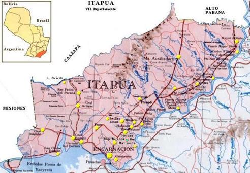
mapsize = 200px
subdivision_type = Country
subdivision_name =Paraguay
subdivision_type1 = Department
subdivision_name1 = Itapúa
leader_title = Intendente Municipal
leader_name = Aldo Numan Lepretti Báez
country = Paraguay
elevation_m =
distance = 365
established_title = Founded
established_date =1789
founder = Joaquín de Alós y Brú
area_magnitude =
area_total_sq_mi =
area_total_km2 = 250
area_land_sq_mi =
area_land_km2 =
area_water_sq_mi =
area_water_km2 =
area_water_percent =
area_urban_sq_mi =
area_urban_km2 =
area_metro_sq_mi =
area_metro_km2 =
population_as_of = 2008
population_note =
population_total = 7.447
population_metro =
population_urban =
population_density_km2 = 29
population_density_sq_mi =
timezone = -4 Gmt
utc_offset =
timezone_DST =
utc_offset_DST =
postal_code_type = Postal code
postal_code = 6980
area_code = (595) (742)
web =
latd = 26 | latm = 06| lats = 27| latNS = S
longd = 54 | longm = 20 | long = 56| longEW = WSan Juan del Paraná is one of the 30 districts of the
Itapúa Department ,Paraguay .Is located to the south of the city of Encarnación, the capital of the department, and it was founded by
Joaquín de Alós y Brú in1789 .Its inhabitants dedicate to low-scale agriculture and to the subsistence cattle.
Area
It has an area of 25 square kilometers with a total population if 7,447 inhabitants and a population density of 29.796 inhabitants per square kilometer.
Climate
This is the most cold zone in the country due to its position in the most southern border, the absence of elevations that stop the southern wind and the high rate of humidity. Its average temperature nearly reaches the 21º Celsius and the minimum temperatures could reach -4º Celsius in the riparian zones. Only in some exceptional cases the temperatures reaches a maximum of 39º Celsius. The rain average is of 1,700 millimeters annually, being
October the most rainy month.Limits
* North: The
Carmen del Paraná district and the city of Encarnación.
* South: After crossing theParaná river and the Middle Isle, is theArgentina .
* West: The Carmen del Paraná district.
* East: The city of Encarnación.Hydrography
Through this district flows the Paraná river and the Caraguatá spring.
Demography
The main social-demographic indicators in the district says:
* Population under 15 years old: 40.8%
* Average of kids per woman: 2.9 kids
* Percentage of Illiterates:8.0%23.6 % of the occupied population dedicates to the primary sector, 27.6% to the secondary sector and 47.1% to the tertiary sector.
* Percentage of the population occupied in agricultural activities: 22.8%
* Percentage of houses with electricity service: 94.7%
* Percentage of houses with water service: 33.8% Population with unsatisfied basic needs in:
* Education: 7.9 %.
* Sanitary infrastructure: 21.1 %.
* Housing quality: 31.2 %.
* Subsistence capacity: 20.1 %.Economy
The inhabitants of this district dedicates to the cultivation of
wheat ,soy and other subsistence products. In the cattle activities, they stock-breed cows and sheeps. Also have many industries.Roads and communication
The most important road is the branch of the Route 1 "Mariscal Francisco Solano López", currently not asphalted, that connects it with the capital of the department, with
Asunción and other locations of the department and the country. The other internal roads are terraced making easier the intercommunication between the districtsHas the telephonic services from Copaco and mobile telephony, besides various communication media and the journals from the capital of the country.
How to get there
Following the Route 1 "Mariscal Francisco Solano López" from Asunción until getting to the 365th kilometer, then taking an not asphalted branch of this road.
Transportation
The roads are good and allow a fluid transit of people and cargo.
Modern transport busses takes the passengers to
Asunción , the capital of the department and other locations of the region.Population
According to the data provided by the General Office of Statistics, Polls and Census, the total population of the San Juan del Paraná district is 7,447 inhabitants, being 3,921 males and 3,526 females.71.99% of the population is settled in the rural zone.
Tourism
The city offers a commercial zone where could be found almost everything that a tourist looks for. This is one of the touristic reference points of Paraguay.
This district is ready to receive water sports. Has beautiful beaches and zones qualified for fishing.
Along the Paraná river and the Caraguatá stream are beautiful beaches special as places for relaxation and touristic attraction.
References
* Tiempos del mundo.
* Geografía del Paraguay.
* Che Retá Paraguay.
* Datos del la DGEEC.
* ABC Color.
* Ultima Hora.
* EVP - Wikipedia
* [http://www.evp.edu.py/index.php?title=Portada Enciclopedia Virtual Paraguaya - Portal]External links
* [http://www.senatur.gov.py/ Secretaria Nacional de Turismo]
* [http://www.dgeec.gov.py// Dirección General de Encuestas, Estadísticas y Censos]
* [http://world-gazetteer.com/wg.php?x=&men=gcis&lng=en&des=wg&geo=-179&srt=npan&col=abcdefghinoq&msz=1500&pt=c&va=x World Gazeteer: Paraguay] – World-Gazetteer.com

Wikimedia Foundation. 2010.