Corrieshalloch Gorge

Corrieshalloch Gorge
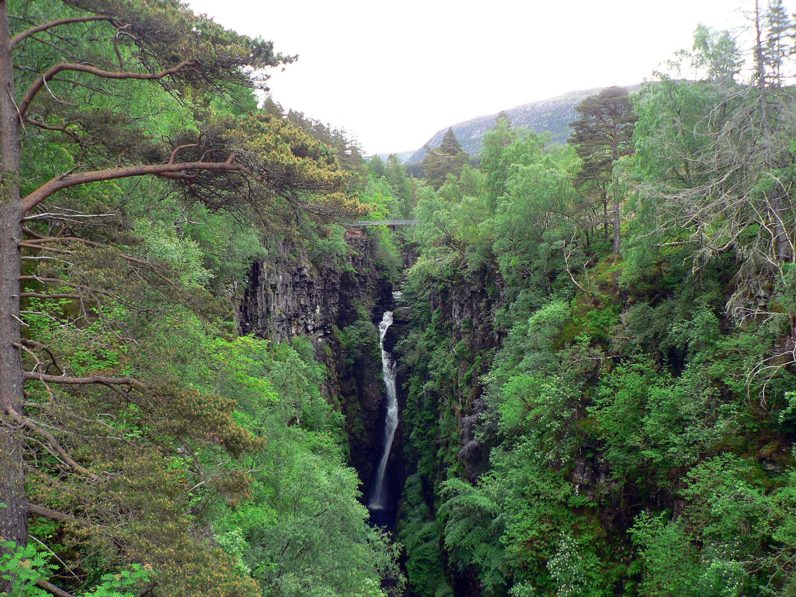
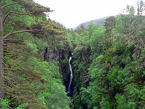
Corrieshalloch Gorge and Falls of Measach
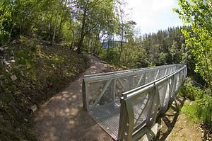
Viewing Platform at Corrieshalloch Gorge

Corrieshalloch Gorge is situated on the Droma River 20 km S of Ullapool (between the A832 and A835 roads near Braemore) in the Scottish Highlands. It is 1.5 km long, 60m deep and formed at the end of the last ice age (10-13,000Y BP) by rapid erosion caused by meltwater. The 46m Falls of Measach can be viewed from a viewing platform and a Victorian suspension footbridge. The gorge and surrounding area are owned by the National Trust for Scotland.

Access to the footbridge is via a 300m path from the car park on the South side of the gorge. There is a charge of 1 UK Pound payable using an honesty box at the start of the path. A viewing platform has been installed which projects out into the Gorge.

The bridge was closed to the public in 2010 following the discovery of unacceptable wear and tear, but was reopened in January 2011 after temporary repair work. It is expected to be closed again in the winter of 2011/12 for longer term repairs.

Coordinates: 57°45′19″N 5°01′13″W / 57.7552°N 5.0204°W / 57.7552; -5.0204


Wikimedia Foundation. 2010.

Игры ⚽ Поможем написать реферат

Look at other dictionaries:

  • Canyon — For other uses, see Canyon (disambiguation). Gorge redirects here. For the figure from Greek mythology, see Gorge (mythology). For the old English meaning, see throat. Grand Canyon, Arizona …   Wikipedia

  • List of Nature Conservation Review sites — The following is a list of sites listed in Derek Ratcliffe s 1979 book A Nature Conservation Review . The headings, subheadings, site codes and site names are the same as those used in the original work.Coastlandsoutheast Englandouth west… …   Wikipedia

  • List of rock formations in the United Kingdom — England= *Brimham Rocks, Nidderdale, Yorkshire *Dovedale, Derbyshire *Cheesewring, Bodmin Moor, Cornwall *Old Harry Rocks, Dorset *Durdle Door, Dorset *Cheddar Gorge and Cave, Somerset *Ebbor Gorge, Somerset *Avon Gorge, Bristol *Lathkill Dale,… …   Wikipedia

  • A832 road — UK road routebox road= A832 length mi= 126 length km= 201 direction= start= Cromarty destinations= end= A835 near Ullapool construction date= completion date= junctions= ukroadsmall|9 ukroadsmall|835 ukroadsmall|862 ukroadsmall|834… …   Wikipedia

  • National Nature Reserves in Scotland — are established by Scottish Natural Heritage. [1] Until 2004 there were 73 National Nature Reserves in Scotland, as per the list below. However, a review carried out in that year resulted in a significant number of sites losing their NNR status.… …   Wikipedia

  • Wester Ross — ( gd. Taobh Siar Rois ) is a western area of Ross shire, notably containing the villages on the west coast such as:* Lochcarron * Applecross * Shieldaig * Torridon * Kinlochewe (inland) * Gairloch * Poolewe * Aultbea * Laide * Ullapool *… …   Wikipedia

  • List of National Trust for Scotland properties — National Trust for Scotland properties is a link page listing the cultural, built and natural heritage properties and sites owned or managed by the National Trust for Scotland. Contents 1 Aberdeen and Grampian 2 Angus 3 Argyll, Bute and Loch… …   Wikipedia

  • List of Sites of Special Scientific Interest in North Wester Ross and Cromarty — The following is a list of Sites of Special Scientific Interest in the North Wester Ross and Cromarty Area of Search. For other areas, see List of SSSIs by Area of Search.* Achnahaird * An Teallach * Ardlair Letterewe * Beinn Dearg * Cailleach… …   Wikipedia

Share the article and excerpts

Direct link
Do a right-click on the link above
and select “Copy Link”