Darvel Bay

Darvel Bay
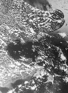
Satellite image of Darvel Bay, 27 July 1980

Darvel Bay or Lahad Datu Bay is a bight (large bay) on the east side of Sabah on the island of Borneo. It is the largest semi-enclosed bay on the east coast of Borneo and faces the Sulawesi Sea. Administratively, it is within Tawau Division, with Lahad Datu District on the north side, Kunak District in the middle and Semporna District to the south of the bay.

Contents

Geography

Large parts of the shore of Darval Bay are mangrove swamps.[1] Within the bay there are numerous islands, the largest, Timbun Mata Island, is located near the southern shore.

History

The area around Darvel Bay has been inhabited for over 20,000 years.[2] The limestone caves on the mainland and on the islands were used for prehistoric burials.[2]

Darvel Bay was a traditional haunt for pirates up to the end of the 19th century.[3] Among the most famous pirates was Datu Kudunding.[4] The British operated the Darvel Bay Tobacco Plantations Ltd, in Lahad Datu District which was immortalized in the documentary film Urban Bioscope Expedition through Borneo by H. M. Lomas.[5]

Notes

  1. ^ United States Navy Publication 163, Chapter 10, prepared by the National Imagery and Mapping Agency
  2. ^ a b Hutton, Wendy (1993) East Malaysia and Brunei Passport Books, Lincolnwood, Illinois, p.77, ISBN 0-8442-9890-5
  3. ^ Tregonning, K. G. (1965) A History of Modern Sabah (North Borneo, 1881–1963) (2nd ed.) published for the University of Singapore by the University of Malaya Press, Singapore, p.191 OCLC 410956
  4. ^ Black, Ian (1983) A Gambling Style of Government: The Establishment of the Chartered Company's rule in Sabah, 1878–1915 Oxford University Press, Kuala Lumpur, p.23, ISBN 0-19-582535-7
  5. ^ Herbert, Stephen (2000) A History of Early Film Routledge, London, p.180-181, ISBN 0-415-21152-2

Further reading

  • Saleh, Ejria et al. (June 2007) "Water circulation in Darvel Bay, Sabah, Malaysia" Abstract In: Institute of Electrical and Electronics Engineers (June 2007) Oceans 2007 – Europe Marine Technology Society, Oceanic Engineering Society (U.S.), Columbia, Maryland, pp. 1–6, ISBN 0-933957-35-1

Coordinates: 4°48′N 118°39′E / 4.8°N 118.65°E / 4.8; 118.65


Wikimedia Foundation. 2010.

Игры ⚽ Нужно сделать НИР?

Look at other dictionaries:

  • Darvel Branch — [v · d · e …   Wikipedia

  • Darvel and Strathaven Railway — [v · Legend …   Wikipedia

  • Scottish place names in other countries — is a list of placenames in Scotland which have subsequently been applied to other parts of the world by Scottish emigrants or , or contain distinctive Scottish surnames as an element.Antarctica* Ailsa Craig (South Orkney Islands) * Anderson… …   Wikipedia

  • Commonwealth banknote-issuing institutions — also British Empire Paper Currency Issuers comprises a list of public, private, state owned banks and other government bodies and Currency Boards who issued legal tender: banknotes. Contents 1 Africa 1.1 Biafra 1.2 Botswana …   Wikipedia

  • Semporna — is a town located in Tawau Division, in the east coast of Sabah, Malaysia on the island of Borneo. Its population was estimated to be around 133,000 in 2006. [ Basic population characteristics by administrative districts 2006 , Department of… …   Wikipedia

  • Tabawan — Island, Tabauawan or Pulau Tabauwan is the highest and largest of a group of heavily wooded islands lying in the southwest quadrant of Darvel Bay (Teluk Lahad Datu), Sabah. It has dual volcanic peaks, and is 275 meters at its highest point. On… …   Wikipedia

  • Lahad Datu — is a town and district located in Tawau Division, in the east of Sabah, eastern Malaysia on the island of Borneo. It occupies the peninsula on the north side of Darvel Bay. Its population was estimated to be around 118,000 in 1991 and 156,059 in… …   Wikipedia

  • Tabin Wildlife Reserve — Tabin Wildlife Refuge is a nature preserve in Sabah, eastern Malaysia, on the island of Borneo. It was created in 1984 to preserve Sabah’s disappearing wild animals. Occupying a large part of the peninsula forming the northern headland of Darvel… …   Wikipedia

  • Timbun Mata — Island (or Pulau Timbun Mata) is the largest island on the south side of Darvel Bay (also known as Teluk Lahad Datu ), in Semporna, Sabah, Malaysia. It is over 26 kilometers long and at the widest is almost 10 kilometers wide. The island is… …   Wikipedia

  • Lesser False Vampire Bat — Conservation status Least Concern ( …   Wikipedia

Share the article and excerpts

Direct link
Do a right-click on the link above
and select “Copy Link”