Eastern Three-lined Skink
- Eastern Three-lined Skink
Taxobox
name = Eastern Three-lined Skink
status = LC
regnum = Animalia
phylum = Chordata
classis = Reptilia
ordo = Squamata
familia = Scincidae
genus = "Bassiana"
species = "B. duperreyi"
binomial = "Bassiana duperreyi"
binomial_authority = (Gray), 1838
synonyms = "Acritoscincus duperreyi", "Leiolopisma trilineata"
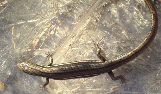
The Eastern Three-lined Skink ("Bassiana duperreyi") is a species of skink in the Scincidae family. It is found in south-eastern Australia, including northern Tasmania and several islands. It is strongly striped, oviparous, and usually found in coastal heaths and warm, sunny areas. [ [http://www.parks.tas.gov.au/wildlife/reptile/Badup.html Wildlife of Tasmania – Eastern Three-lined Skink] ] [Cogger, H.G. (1979). "Reptiles and Amphibians of Australia". Reed: Sydney. ISBN 0-589-50108-9] ]References
Wikimedia Foundation.
2010.
Look at other dictionaries:
Great Dog Island (Tasmania) — Great Dog Island, also known as Big Dog Island, is a granite island, with an area of 354 ha, in south eastern Australia. It is part of Tasmania’s Great Dog Island Group, lying in eastern Bass Strait between Flinders and Cape Barren Islands in the … Wikipedia
Long Island (Tasmania) — Long Island is a granite and dolerite island, with an area of 313 ha, in south eastern Australia. It is part of Tasmania’s Long Island Group, lying in eastern Bass Strait north west of Cape Barren Island in the Furneaux Group.HistoryThe island… … Wikipedia
Erith Island (Tasmania) — Erith Island is a granite island, with an area of 323 ha, in south eastern Australia. It is the second largest of Tasmania’s Kent Group, lying in northern Bass Strait between the Furneaux Group and Wilsons Promontory in Victoria. It is now part… … Wikipedia
Inner Little Goose Island — is a small, round granite island, with an area of 4.5 ha, in south eastern Australia. It is part of Tasmania’s Badger Island Group, lying in eastern Bass Strait between Goose and Little Goose Islands, west of Flinders and Cape Barren Islands in… … Wikipedia
Schouten Island — is a 34 km2 island in eastern Tasmania, Australia. It is one kilometre south of the Freycinet Peninsula, at coord|42.3180556|S|148.28|E| and is a part of the Freycinet National Park. There is a lighthouse on the island.HistorySchouten Island lay… … Wikipedia
Waterhouse Island (Tasmania) — Waterhouse Island is an island, with an area of 287 ha, in south eastern Australia. It is part of the Waterhouse Island Group, lying close to the north eastern coast of Tasmania. Most of it has been leased for farming and it contains a homestead … Wikipedia
Babel Island — is a granite island, with an area of 440 ha, in south eastern Australia. It is part of Tasmania’s Babel Island Group, lying in eastern Bass Strait off the east coast of Flinders Island in the Furneaux Group. It is home to the largest colony of… … Wikipedia
Hogan Island — is a granite island, with an area of 232 ha (573 acres) and a high point of 116 m (380 feet), in south eastern Australia. It is the largest of Tasmania’s Hogan Group, lying in northern Bass Strait between the Furneaux Group and Wilsons Promontory … Wikipedia
Mount Chappell Island — was originally named Mount Chappelle by Matthew Flinders for his wife s maiden name.[1] It is a mainly dolerite island, with a distinctive central hill and with an area of 323 ha, in south eastern Australia. It is part of Tasmania’s Badger Island … Wikipedia
Inner Sister Island — is an island, with an area of 748 ha, in south eastern Australia. It is part of Tasmania’s Sisters Island Group, lying in eastern Bass Strait off the northern point of Flinders Island in the Furneaux Group. The island is grazed by sheep and… … Wikipedia