Couthenans

Couthenans

Couthenans

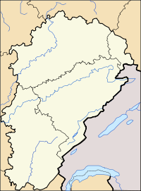
Couthenans is located in France
{{{alt}}}
Couthenans
Administration
Country France
Region Franche-Comté
Department Haute-Saône
Arrondissement Lure
Canton Héricourt-Ouest
Statistics
Elevation 331–480 m (1,086–1,570 ft)
Land area1 1.64 km2 (0.63 sq mi)
Population2 820  (2006)
 - Density 500 /km2 (1,300 /sq mi)
INSEE/Postal code 70184/ 70400
1 French Land Register data, which excludes lakes, ponds, glaciers > 1 km² (0.386 sq mi or 247 acres) and river estuaries.
2 Population without double counting: residents of multiple communes (e.g., students and military personnel) only counted once.

Coordinates: 47°35′29″N 6°43′34″E / 47.5913888889°N 6.72611111111°E / 47.5913888889; 6.72611111111

Couthenans is a commune in the Haute-Saône department in the region of Franche-Comté in eastern France.

See also

References


Wikimedia Foundation. 2010.

Игры ⚽ Поможем написать курсовую

Look at other dictionaries:

  • Couthenans — Couthenans …   Deutsch Wikipedia

  • Couthenans — Saltar a navegación, búsqueda Couthenans País …   Wikipedia Español

  • Couthenans — 47° 35′ 29″ N 6° 43′ 34″ E / 47.5914, 6.7261 …   Wikipédia en Français

  • Route nationale 19 (France) — Pour les articles homonymes, voir N19 et Route nationale 19. Route nationale 19 N 19 Caractéristiques Longueur 447 km …   Wikipédia en Français

  • Hericourt — Héricourt DEC …   Deutsch Wikipedia

  • Coisevaux — Coisevaux …   Deutsch Wikipedia

  • Principauté de Montbéliard — Grafschaft Mömpelgard (de) 1042 – 1793 armoiries …   Wikipédia en Français

  • Etobon — Étobon DEC …   Deutsch Wikipedia

  • Tremoins — Trémoins DEC …   Deutsch Wikipedia

  • Vians — Vyans le Val DEC …   Deutsch Wikipedia

Share the article and excerpts

Direct link
Do a right-click on the link above
and select “Copy Link”