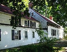
- Abraham Manee House
-
New Netherland series Exploration Fortifications: • Fort Nassau (North)
• Fort Orange
• Fort Nassau (South)
• Fort Goede Hoop
• De Wal
• Fort Wilhelmus
• Fort Beversreede
• Fort Nya Korsholm
• De Rondout
Settlements: • Rensselaerswyck
• Beverwijck
• Wiltwyck
• Bergen
• Pavonia
• Vriessendael
• Achter Col
• Heemstede
• Rustdorp
• Midwout
• Boswyck
• Swaanendael
The Patroon System Directors of New Netherland: Cornelius Jacobsen May (1620-25)
Willem Verhulst (1625-26)
Peter Minuit (1626-32)
Sebastiaen Jansen Krol (1632-33)
Wouter van Twiller (1633-38)
Willem Kieft (1638-47)
Peter Stuyvesant (1647-64)
People of New Netherland Flushing Remonstrance The Abraham Manee House, also known as the Manee-Seguine Homestead, is a three-part Colonial Dutch dwelling similar to the Billiou-Stillwell-Perine House in Old Town, and was designated a New York City landmark in 1984. Located on the South Shore of Staten Island on Purdy Avenue, and adjacent to Lemon Creek, the oldest section is a one-room structure built by Paulus Regrenier in 1670, a French Huguenot fleeing religious persecution in Europe.
An addition made of rubble-stone and Tabby, was added by another early French Huguenot settler, Abraham Manee in the late 18th century. The Seguine family purchased the homestead in the 1780s and built a wooden addition in the early part of the 19th century.
It was a Tavern/Inn named Purdy's Hotel in the late 19th century.
Of architectural noteworthiness are the Spring-Eaves that are evident of Flemish design on the North side of the house. It is purported to be one of the oldest Dutch structures on Staten Island (dated circa 1670) and is threatened with demolition.[citation needed]
See also
References
- "Cultural Resources" (PDF). New York City. http://www.nyc.gov/html/doh/downloads/pdf/wnv/f3k.pdf. Retrieved 2008-02-18.
- Neighborhood Preservation Center 509 Seguine Avenue
- Dolkart, Andrew; Matthew A. Postal (2003). Guide to New York City Landmarks. John Wiley and Sons. pp. p. 360. ISBN 0-471-36900-4.
External links
- Abraham Manee Hse/Manee-Seguine Homestead at Endangered Buildings Online
- Neighborhood Preservation Center, NY, NY
Coordinates: 40°30′55″N 74°11′51″W / 40.515198°N 74.197559°W
New York City Historic Sites NRHP: Manhattan – Brooklyn – Queens – Staten Island – Bronx • NHL: New York State
NYC: Manhattan – Brooklyn – Queens – Staten Island – Bronx
Categories:- Buildings and structures completed in 1670
- Landmarks in New York City
- Houses in Staten Island
- New York City building and structure stubs
Wikimedia Foundation. 2010.


