- Tubutama
Infobox Settlement
official_name = Tubutama
other_name =
native_name =
nickname =
settlement_type =
motto =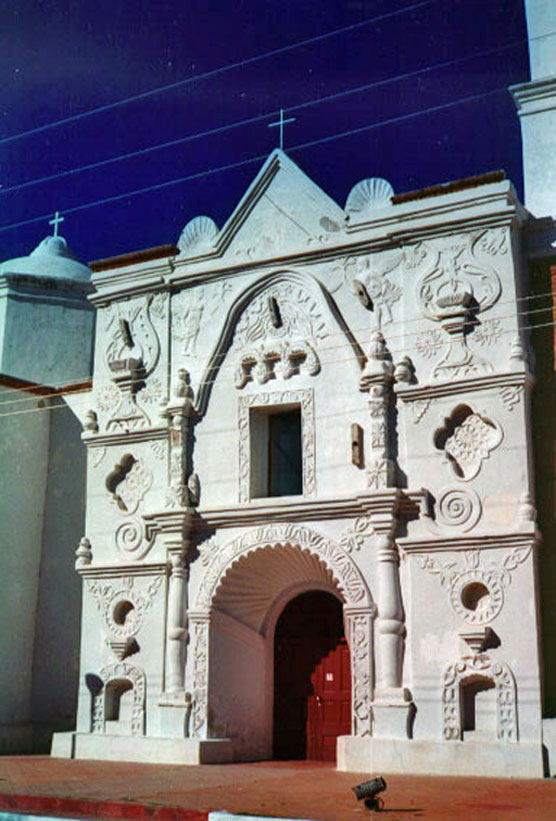
imagesize =
image_caption =Mission San Pedro y San Pablo de Tubutama
flag_size =
image_
seal_size =
image_shield =
shield_size =
city_logo =
citylogo_size =
mapsize =
map_caption =
mapsize1 =
map_caption1 =
image_dot_
dot_mapsize =
dot_map_caption =
dot_x = |dot_y =
pushpin_
pushpin_label_position =
pushpin_map_caption = Location in Mexico
pushpin_mapsize =
subdivision_type = Country
subdivision_name = MEX
subdivision_type1 = State
subdivision_name1 =Sonora
subdivision_type2 =Municipality
subdivision_name2 = Tubutama
subdivision_type3 =
subdivision_name3 =
subdivision_type4 =
subdivision_name4 =
government_footnotes =
government_type =
leader_title =Mayor
leader_name =Karina García Gutierrez
leader_title1 =
leader_name1 =
leader_title2 =
leader_name2 =
leader_title3 =
leader_name3 =
leader_title4 =
leader_name4 =
established_title = Founded
established_date = late C.17th
established_title2 =
established_date2 =
established_title3 =
established_date3 =
area_magnitude =
unit_pref =
area_footnotes =
area_total_km2 =
area_land_km2 =
area_water_km2 =
area_total_sq_mi =
area_land_sq_mi =
area_water_sq_mi =
area_water_percent =
area_urban_km2 =
area_urban_sq_mi =
area_metro_km2 =
area_metro_sq_mi =
area_blank1_title =
area_blank1_km2 =
area_blank1_sq_mi =
population_as_of =
population_footnotes =
population_note =
population_total =
population_density_km2 =
population_density_sq_mi =
population_metro =
population_density_metro_km2 =
population_density_metro_sq_mi =
population_urban =
population_density_urban_km2 =
population_density_urban_sq_mi =
population_blank1_title =Municipality
population_blank1 =
population_blank2_title =Demonym
population_blank2 =
population_density_blank1_km2 =
population_density_blank1_sq_mi =
timezone = MST
utc_offset = -7
timezone_DST =
utc_offset_DST =
latd=30 |latm=52 |lats= |latNS=N
longd=111 |longm=27 |longs= |longEW=W
elevation_footnotes =
elevation_m =
elevation_ft =
postal_code_type = Postal code
postal_code =
area_code =
blank_name =
blank_info =
blank1_name =
blank1_info =
website =
footnotes =Tubutama is a town, and the surrounding municipality of the same name, in the north-west of the
Mexican state ofSonora . It was founded in the late 17th century by Fr.Francisco Eusebio Kino . It was the headquarters of religious administration for the entire Pimeria Alta during much of theJesuit andFranciscan period of Spanish colonial rule.The municipal area is 1,351.60 sq.km. and the population was 1,798 in 2005. The main economic activities are cattle raising (11,000 head in 2005) and subsistence farming.
Tourists can visit the Mission of San Pedro and San Pablo, built by Jesuit missionary Eusebio Francisco Kino at the end of the seventeenth century. The arched entrance is
mudejar and in the interior the transept is dedicated to the Passion of Christ and the altarpiece has sculptured instruments of the Passion: crown of thorns, scourge, nails, tongs, ladder, and lances. A sculptured serpent crawls beneath an upper niche in the same altarpiece. This recess now holds a carved statue of Our Lady of Aránzazu, an image of the Virgin Mary as she appeared at Aránzazu in the Basque country of northern Spain.ee also
*
Mission San Pedro y San Pablo del Tubutama External links
* [http://www.e-local.gob.mx/work/templates/enciclo/sonora/municipios/26065a.htm Tubutama, Sonora] "(Enciclopedia de los Municipios de México)"
* [http://www.nps.gov/archive/tuma/Tubutama.html Mission Pedro y San Pablo del Tubutama]

Wikimedia Foundation. 2010.