- Atil, Sonora
Infobox Settlement
official_name = Atil
other_name =
native_name =
nickname =
settlement_type =
motto =
imagesize =
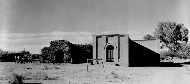
image_caption = Mission Santa Teresa de Atil
flag_size =
image_
seal_size =
image_shield =
shield_size =
city_logo =
citylogo_size =
mapsize =
map_caption =
mapsize1 =
map_caption1 =
image_dot_
dot_mapsize =
dot_map_caption =
dot_x = |dot_y =
pushpin_
pushpin_label_position =
pushpin_map_caption = Location in Mexico
pushpin_mapsize =
subdivision_type = Country
subdivision_name = MEX
subdivision_type1 = State
subdivision_name1 =Sonora
subdivision_type2 =Municipality
subdivision_name2 = Atil
subdivision_type3 =
subdivision_name3 =
subdivision_type4 =
subdivision_name4 =
government_footnotes =
government_type =
leader_title =Mayor
leader_name =
leader_title1 =
leader_name1 =
leader_title2 =
leader_name2 =
leader_title3 =
leader_name3 =
leader_title4 =
leader_name4 =
established_title = Founded
established_date =1751
established_title2 =
established_date2 =
established_title3 =
established_date3 =
area_magnitude =
unit_pref =
area_footnotes =
area_total_km2 = 400.43
area_land_km2 =
area_water_km2 =
area_total_sq_mi =
area_land_sq_mi =
area_water_sq_mi =
area_water_percent =
area_urban_km2 =
area_urban_sq_mi =
area_metro_km2 =
area_metro_sq_mi =
area_blank1_title =
area_blank1_km2 =
area_blank1_sq_mi =
population_as_of =2005
population_footnotes =
population_note =
population_total =734
population_density_km2 =
population_density_sq_mi =
population_metro =699
population_density_metro_km2 =
population_density_metro_sq_mi =
population_urban =
population_density_urban_km2 =
population_density_urban_sq_mi =
population_blank1_title =Municipality
population_blank1 =
population_blank2_title =Demonym
population_blank2 =
population_density_blank1_km2 =
population_density_blank1_sq_mi =
timezone = MST
utc_offset = -7
timezone_DST =
utc_offset_DST =
latd=30 |latm=50|lats=37 |latNS=N
longd=111|longm=35 |longs=1 |longEW=W
elevation_footnotes =
elevation_m =
elevation_ft =
postal_code_type = Postal code
postal_code =
area_code =
blank_name =
blank_info =
blank1_name =
blank1_info =
website =
footnotes =Atil (also Átil) is a small town and municipality in the northwest of the
Mexican state ofSonora . The total area is 400.43 km² and the population of the municipality was 734 in 2005, of whom 699 lived in the municipal seat (2000). Neighboring municipalities areTubutama ,Trincheras ,Oquitoa , and Altar.It was founded in 1751 by the
Jesuit missionaryJacobo Sedelmayer as a mission with the name of Atil. The first inhabitants were Pima Alto or Nebome Indians, who before conversion had led a nomadic or semi-nomadic life.Atil is one of the smallest municipalities in the state. It is said that its name means "Arrow Point", in the Pima language. [http://www.e-local.gob.mx/wb2/ELOCAL/EMM_sonora]
The terrain is desert and mostly flat. Summer temperatures average 25.6°C but daytime extremes are frequently above 40°C. The winter average is 12.8°C.
There is one tarmacked road crossing the municipality linking Altar with
Tubutama . There are several dirt roads crossing the desert.The economy is based on agriculture with lands irrigated by the Cuautémoc Reservoir located in the north of the municipality. There is also cattle raising.
ources consulted
* [http://www.sonora.gob.mx/portal/RunScript.asp?page=176&p=ASPPg176.asp/ Gobierno de Sonora]
* [http://www.e-local.gob.mx/wb2/ELOCAL/EMM_sonora/ Enciclopedia de los Municipios de Mexico]
* [http://www.inegi.gob.mx/inegi/default.aspx/ Instituto Nacional de Estadística, Geografia, e Informática (INEGI)]ee also
Santa Teresa de Atil
Wikimedia Foundation. 2010.

