Doughboy Island East

Doughboy Island East
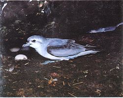
The island is a breeding site for Fairy Prions

Doughboy Island East is an island nature reserve, with an area of 7.01 ha, in south-eastern Australia. It is part of Tasmania’s Trefoil Island Group, lying close to Cape Grim, Tasmania’s most north-westerly point, in Bass Strait.[1]

Fauna

The island forms part of the Hunter Island Group Important Bird Area.[2] Breeding seabird and shorebird species include Little Penguin, Short-tailed Shearwater, Fairy Prion, Common Diving-Petrel, Pacific Gull, Silver Gull and Sooty Oystercatcher. Reptiles include Metallic Skink.[1]

References

  1. ^ a b Brothers, Nigel; Pemberton, David; Pryor, Helen; & Halley, Vanessa. (2001). Tasmania’s Offshore Islands: seabirds and other natural features. Tasmanian Museum and Art Gallery: Hobart. ISBN 0-7246-4816-X
  2. ^ BirdLife International. (2011). Important Bird Areas factsheet: Hunter Island Group. Downloaded from http://www.birdlife.org on 2011-07-09.

Coordinates: 40°40′S 144°40′E / 40.667°S 144.667°E / -40.667; 144.667


Wikimedia Foundation. 2010.

Игры ⚽ Поможем сделать НИР

Look at other dictionaries:

  • Doughboy Island — may refer to: Doughboy Island (Tasmania) Doughboy Island East Doughboy Island West This disambiguation page lists articles about distinct geographical locations with the same name. If an …   Wikipedia

  • Doughboy Island (Tasmania) — Doughboy Island is in the top right of this photo taken from the south east Doughboy Island is a mainly granite island, with an area of 30 ha, in south eastern Australia. It is part of Tasmania’s Tin Kettle Island Group, lying in eastern Bass… …   Wikipedia

  • Stewart Island — one of the islands of New Zealand, S of South Island. 329; 670 sq. mi. (1735 sq. km). * * * ▪ island, New Zealand       third largest island of New Zealand, in the southwest Pacific Ocean off the southern tip of South Island. Roughly triangular… …   Universalium

  • List of dual place names in New Zealand — The agreed dual name of Te Koko o Kupe / Cloudy Bay remembers both the Māori and British explorations of New Zealand. Many official place names in New Zealand are dual names, incorporating both the original Māori place names and the English names …   Wikipedia

  • Overton Park — may also refer to the U.S. Supreme Court case, Citizens to Preserve Overton Park v. Volpe Overton Park Historic District U.S. National Register of Historic Places …   Wikipedia

  • Woodside, Queens — Woodside is a neighborhood in the New York City borough of Queens. It is bordered on the south by Maspeth, on the north by Astoria, on the west by Sunnyside and on the east by Elmhurst and Jackson Heights. Its ZIP code is 11377. Some areas are… …   Wikipedia

  • Hudson County, New Jersey — Infobox U.S. County county = Hudson County state = New Jersey map size = 100 founded = 1840 seat = Jersey City largest city = Jersey City | area total km2 = 162 area total sq mi = 62 area land km2 = 121 area land sq mi = 47 area water km2 = 41 |… …   Wikipedia

  • Ice Cube — For cubes of ice, see Ice cube. For other uses, see Ice cube (disambiguation). Ice Cube Ice Cube performing in Toronto, 2006. Background information Birth name …   Wikipedia

  • Historic districts in Meridian, Mississippi —  1  East End Historic District  6  Merrehope Historic District …   Wikipedia

  • USS Washington (ACR-11) — The seventh USS Washington (ACR 11), also referred to as Armored Cruiser No. 11 , and later renamed Seattle and renumbered CA 11 and IX 39, was a United States Navy Tennessee class armored cruiser. She was laid down on 23 September 1903 at Camden …   Wikipedia

Share the article and excerpts

Direct link
Do a right-click on the link above
and select “Copy Link”