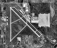
- Mineral Wells Airport
-

IATA: MWL – ICAO: KMWL Summary Airport type Public Operator City of Mineral Wells, Texas Location Mineral Wells, Texas Elevation AMSL 974 ft / 297 m Coordinates 32°46′53.78″N 098°03′36.63″W / 32.7816056°N 98.060175°WCoordinates: 32°46′53.78″N 098°03′36.63″W / 32.7816056°N 98.060175°W Runways Direction Length Surface ft m 13/31 5,996 1,828 Asphalt 17/35 4,188 1,277 Asphalt Mineral Wells Airport (IATA: MWL, ICAO: KMWL) is a general aviation airport located within city limits, 3 miles (4.8 km) SE of central Mineral Wells, Texas.
It is owned and operated by the city of Mineral Wells, Texas. The airport, as does the city, lies in both Palo Pinto County and Parker County. Its terminal lies in Parker County.
Contents
History
Previous entry was for Ft Wolters and not the airport.
See also
References
- AirNav.Com - Mineral Wells Airport (KMWL)
- Thole, Lou (1999), Forgotten Fields of America : World War II Bases and Training, Then and Now - Vol. 2. Publisher: Pictorial Histories Pub, ISBN 1575100517
External links
- Resources for this airport:
- AirNav airport information for KMWL
- ASN accident history for MWL
- FlightAware airport information and live flight tracker
- NOAA/NWS latest weather observations
- SkyVector aeronautical chart for KMWL
- FAA current MWL delay information
Categories:- Airfields of the United States Army Air Forces in Texas
- Airports in Texas
- Buildings and structures in Palo Pinto County, Texas
- Buildings and structures in Parker County, Texas
- Transportation in Parker County, Texas
- Transportation in Palo Pinto County, Texas
Wikimedia Foundation. 2010.

