- Ozone Park (LIRR station)
-
Ozone Park 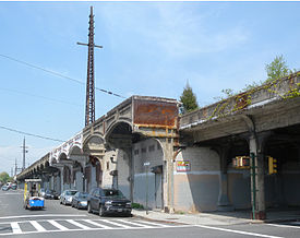
Site of the former Ozone Park Station; April 2010.Station statistics Address Pennsylvania Street and Flatbush Avenue Lines Connections Atlantic Branch Platforms 2 side platforms Tracks 4 Other information Opened 1884 Closed June 8, 1962 Rebuilt 1930-1931; station abandoned Electrified 1905 Code None Owned by MTA Fare zone 1 Services None Preceding station LIRR Following station toward Rego ParkRockaway Beach Branch Aqueducttoward Rockaway ParkOzone Park is a former Long Island Rail Road station. Ozone Park station was set up to enable passengers from Pennsylvania Station and Flatbush Avenue to reach the Rockaway Park area or Far Rockaway section simply by changing trains ("Change At Ozone Park!"). The trains would stack end-to-end, and passengers would transfer back and forth on the platform. Operation in the reverse direction also occurred. Due to street restrictions below, which limited the right-of-way width above, platforms were on the outside of the four track right-of-way, making an across-the-platform exchange impossible. To accommodate this, the platforms were made exceptionally long, so that non-rush hour length MU trains could stack end-to-end and allow passengers to transfer. A set of crossovers from the outside tracks to the inner tracks were at the east end of the station, to permit trains stopping at Ozone Park to run express after the station stop, or to perform the reverse move.
Ozone Park along with remaining stations of the Rockaway Beach Branch still operated by the LIRR, after the 1955 takeover of the line south of Liberty Avenue by the transit authority, were abandoned in 1962 when service between Rego Park and Ozone Park ended. The station and right of way remained intact though with the thought that the transit authority would eventually take over the line north of Liberty Avenue, a proposal that never took place. Ozone Park station remains in place as of current (2009) though in a dilapidated state along with electric utility poles and signal bridges the adorn the right of way.
Since the closing of the line many businesses in the area have set up shop in the portion of trestle below the station. In the late 1980s the F.B.I. used the abandoned platforms to set up a sting operation to monitor the activities of John Gotti and the Gambino crime family, whose social club was down the street from the station.
See also
References
- Former Rockaway Beach Branch, including Ozone Park Station (Forgotten New York)
- LIRR Station History (TrainsAreFun.com)
 1891 Map of Ozone Park Station
Coordinates: 40°41′04″N 73°50′30.75″W / 40.68444°N 73.841875°W
Categories:- Former Long Island Rail Road stations
- Railway stations opened in 1884
- Railway stations closed in 1962
- New York railway station stubs

Wikimedia Foundation. 2010.