- Olinger Strip
-
Olinger Strip Airport 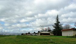
Landing strip from the east IATA: none – ICAO: none – FAA LID: OR81 Summary Airport type Private Owner Richard Wood Location Hillsboro, Oregon Elevation AMSL 185 ft / 56 m Coordinates 45°33′11″N 123°01′15″W / 45.55306°N 123.02083°WCoordinates: 45°33′11″N 123°01′15″W / 45.55306°N 123.02083°W Runways Direction Length Surface ft m 07/25 2,000 609 Turf-gravel Olinger Strip Airport (FAA LID: OR81) is a private airport located 3 miles west of Hillsboro in Washington County, Oregon, USA. Located in the unincorporated community of Leisyville, the air strip is a single, 2,000-foot (610 m) long runway with houses running the length of the field on the north of the strip.
Contents
History
The airpark was started by Bill Olinger in the late 1950s and opened in 1958.[1][2] Olinger was selling empty lots on the airstrip in the early 1960s for $1,800, which included a partial ownership of the airport itself.[3] In February 1975, a plane that took off from the field crashed 20 minutes later as the pilots practiced aerobatic maneuvers, killing one person.[4] The strip was built on the site of a former hop farm and had grown to 12 homes along the strip in 1976.[1]
Details
The runway at the air park is a 2,000-foot (610 m) turf strip, which is maintained by the homeowners association.[2] Olinger Strip is classified by the state's Department of Aviation as a privately owned, private use airport with at least three aircraft based at the airport.[5] This designation allows the county to regulate heights of objects in the airplane approaches to the landing strip.[6] Washington County approved these regulations in 2003, which also allowed for the Olinger Strip and like airports to expand by more than the previously allowed 20 percent.[7]
References
- ^ a b Goldmann, Judy (October 19, 1976). "Communities: Tualatin Indians roamed farmland before Leisyville was community". Hillsboro Argus: p. 5.
- ^ a b Gallivan, Joseph (July 17, 2007). "Aloft living". The Portland Tribune (Portland, Ore.). http://www.portlandtribune.com/features/story.php?story_id=118443982897727800. Retrieved 11 November 2010.
- ^ "Land In Your Back Yard (classified advertisement)". The Oregonian: p. 32. August 4, 1962.
- ^ Hobart, Sue (February 6, 1975). "Plane crash kills 1; 2nd escapes unhurt". The Oregonian: p. 1.
- ^ "Appendix N". Airport Land Use Compatibility Guidebook. Oregon Department of Aviation. January 2003. http://www.aviation.state.or.us/Aviation/docs/resources/AppendixN.pdf. Retrieved 4 March 2010.
- ^ "Airports". Washington County Rural/Natural Resource Plan Element. Washington County Land Use and Transportation Department. April 25, 2005. http://www.co.washington.or.us/LUT/Divisions/LongRangePlanning/loader.cfm?csModule=security/getfile&pageid=160850. Retrieved 4 March 2010.
- ^ Gunderson, Laura (September 25, 2003). "West Zoner: Critics raise a flap about changing rules for airports". The Oregonian: p. 1.
External links
- Resources for this airport:
- AirNav airport information for OR81
- FlightAware airport information and live flight tracker
- SkyVector aeronautical chart for OR81
Categories:- Airports in Washington County, Oregon
- Oregon airport stubs

Wikimedia Foundation. 2010.