Maps of San Jose, California
- Maps of San Jose, California
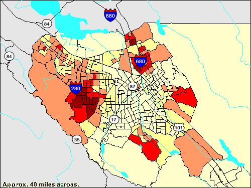
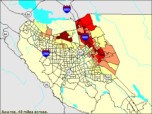
These thematic maps of the San Jose, California metropolitan area illustrate the different neighborhoods and the contrasting demographics of the diverse city. East San Jose is a lower-income area consisting mainly of Hispanics. On the other hand, the affluent western cities of Cupertino, Saratoga, and Palo Alto are upper-class Asian communities with housing worth $900,000 or so. Many residents in western Santa Clara Valley work in San Jose's computer industry.
Please click on the images for a larger view or for more information on it. The images are generated at the U.S. Census' American Factfinder. ( [http://factfinder.census.gov] ) The geographic limit is the block group (BG) level.
Racial and ethnic groups
 Asian population
[
 Hispanic or Latino population]
[
 White population]
[
 African American population]
[
 Latino (excluding
  Mexicans, Cubans, and Puerto Ricans population]
Asians
 ">
">
Chinese population

 Vietnamese population
 ">
">
Filipino population
[
 Indian population]
[
 Japanese population]
Age and sex
Housing
[
 1940]
1940]
Economy
[
 income]
[
 income]
[
 poverty level]
[
 Unemployment rate]
[
 labor force]
[
 labor force]
Area of industry
Transportation and utilities access
[
 telephone service]
Social characteristics
[
 High school graduates]
[
 Veterans]
See also
* San Jose, California
Wikimedia Foundation.
2010.
Look at other dictionaries:
San José (California) — Saltar a navegación, búsqueda San José, California Apodo(s): Capital of Silicon Valley … Wikipedia Español
Bret Harte Middle School (San Jose, California) — articleissues refimprove=May 2007 cleanup=July 2007 introrewrite=April 2008 original research=April 2008Infobox School2 | name =Bret Harte Middle School motto = established = 1922 type =Public middle school locale = grades =6 8 head name… … Wikipedia
West San Jose, San Jose, California — West San Jose is the westernmost neighborhood in San Jose, California. The Lynbrook High School area of West San Jose is bound to the north by Bollinger Road, to the east by Lawrence Expressway, to the south by Prospect Road, and to the west by… … Wikipedia
San Carlos, California — Infobox Settlement official name = San Carlos, California other name = native name = nickname = settlement type = City motto = imagesize = image caption = flag size = image seal size = image shield = shield size = image blank emblem = blank… … Wikipedia
San Francisco, California — Infobox Settlement official name = City and County of San Francisco nickname = The City by the Bay, The CityFact|date=October 2008, Frisco, [cite news last = Sullivan | first = James title = Frisco, that once verboten term for the city by the bay … Wikipedia
Balboa Park, San Francisco, California — Balboa Park is a neighborhood and public park in San Francisco, California. The neighborhood (sometimes referred to as Mission Terrace, Cayuga, or Ingleside) is located between Mission Street and Interstate 280 north of Geneva Avenue and the park … Wikipedia
San Francisco Bay Area — Bay Area redirects here. For other uses, see Bay Area (disambiguation). Not to be confused with San Francisco Bay Area Combined Statistical Area. San Francisco Bay Area Common name: San Fran … Wikipedia
California State Route 85 — State Route 85 West Valley Freeway … Wikipedia
California State Route 130 — Infobox road state=CA type=SR route=130 section=430 maint= length mi=22.503 length round=3 length ref= established= direction a=West terminus a=jct|state=CA|US|101 in San Jose direction b=East terminus b=Mount Hamilton previous type=SR previous… … Wikipedia
José María Narváez — (1768 ndash; August 4, 1840) was a Spanish naval officer, explorer, and navigator who is mainly remembered for his work in the Pacific Northwest. He was born in Cádiz, Spain. In 1791, as commander of the schooner Santa Saturnina , he led the… … Wikipedia
 Asian population


Mexicans,
 ">
">
Vietnamese population
 ">
">


