- Muur van Geraardsbergen
-
Coordinates: 50°46′21″N 3°53′24″E / 50.7725°N 3.89°E
Muur van Geraardsbergen 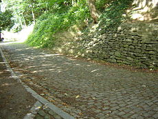
The Muur van Geraardsbergen.Elevation 110 m Location Flanders, Belgium Start Geraardsbergen Altitude 92 m Length 1075 m Average gradient 9,3 % Maximum gradient 19,8 % 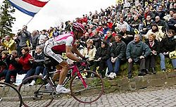
The Muur van Geraardsbergen (English: Wall of Geraardsbergen/Grammont, French: Mur de Grammont) is a steep narrow road with cobblestones located in Geraardsbergen, Belgium. It is also known as Kapelmuur, Muur-Kapelmuur or simply Muur. The hill starts near the river Dender at 18 m and reaches the top of the Oudenberg at 110 m. This climb is famous for being part of the route of Ronde van Vlaanderen professional cycling race.
Ronde van Vlaanderen
The Muur van Geraardsbergen is the penultimate climb in the Ronde van Vlaanderen, 16 km from the finishing line. It has been part of the race since 1950, although not consistently until 1981. According to the database at salite.ch[1] the climb has a length of 1 kilometer with an average grade of 7.7%. However, the official data[2] from the race say the following: length 475 meters, average 9.3%, max 19.8% (all cobbles).
In 2010, Fabian Cancellara drove away from Tom Boonen in an attack on the Muur, and won the Ronde van Vlaanderen.
References
- ^ www.salite.ch
- ^ Bjorn Haake (11 December 11 2009). "Dramatic changes for the 2010 Ronde van Vlaanderen". VeloNation. http://www.velonation.com/News/ID/2476/Dramatic-changes-for-the-2010-Ronde-van-Vlaanderen.aspx. Retrieved 3 April 2011.
External links
Categories:- Climbs in cycle racing
- Mountains and hills of Belgium
- Tour of Flanders
- Cycling stubs
- Belgian sport stubs


Wikimedia Foundation. 2010.