- Ngwatle
-
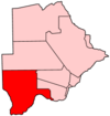
Ngwatle is a village in Kgalagadi District of Botswana. It is located in the Kalahari Desert, in the north-west part of the district. The population was 206 in 2001 census.[1]
References
- ^ "Distribution of population by sex by villages and their associated localities: 2001 population and housing census". Archived from the original on 2007-11-24. http://web.archive.org/web/20071124145611/http://www.cso.gov.bw/html/census/dist90_91.html. Retrieved 2007-12-20.
Urban villages 
Rural villages Bogogobo · Bokspits · Bray · Gachibana · Hukuntsi · Hunhukwe · Inalegolo · Kang · Khisa · Khuis · Khwawa · Kokotsha · Kolonkwane · Lehututu · Lokgwabe · Make · Makopong · Maleshe · Maralaleng · Maubelo · Middlepits · Monong · Ncaang · Ngwatle · Omaweneno · Phepheng · Phuduhudu · Rapples Pan · Struizendam · Tshane · Ukwi · Vaalhoek · Werda · ZutswaCategories:- Botswana geography stubs
- Kgalagadi District
- Villages in Botswana
Wikimedia Foundation. 2010.

