Namonuito Atoll

Namonuito Atoll

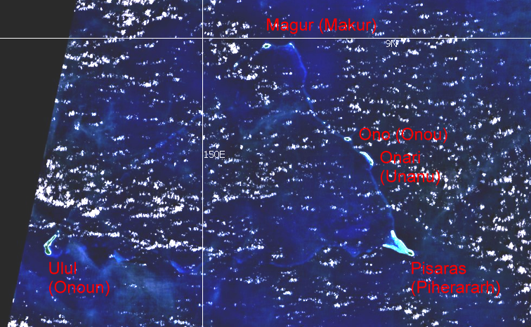
Coordinates: 08°40′00″N 150°00′00″E / 8.6666667°N 150°E / 8.6666667; 150 Namonuito Atoll, also called Namonweito, Weito, or Magur Islands, is the largest atoll of the Federated States of Micronesia and of the Caroline Islands, with a total area of 2267 km², unless one considers the still larger Truk Lagoon as a type of atoll in an early stage of development. In Micronesia, only Kwajalein Atoll of the Marshall Islands is larger.

Namonuito Atoll lies in the northwestern region (Oksoritod) of Chuuk State, the largest federal State of the Federated States of Micronesia, about 170 km northeast of Truk Lagoon (measured from Pisaras Islet to the northern and western parts of the fringing reef of Truk Lagoon). It is roughly triangular in shape, with the base running 82 km along its southern side. The southwest corner of the triangle is marked by Ulul islet, the main island (largest and most populated), also called Onoun. The other islets lie mostly on the northeast side, from Pisaras islet in the southeast corner to Magur (Makur) islet in the north corner. The 12 islets have an aggregate land area of only 4.5 km². The total population is 1.341 (census of 2000).

The reef rim of the atoll is submerged for the greater part and is marked by the lighter color of the water over it. The depths on the reef range from 0.9 to 18.3 meters. The reef appears to be in the process of formation and can be crossed at many places. The lagoon is not of uniform depth. Except for a 5.5 meter patch, located 22 km west of Pisaras island, and a detached reef, with depths of 2.7 to 3.7 meters, located about 10 km of Pisaras, there appears to be no less than 9 meters on the scattered coral heads.

Pisaras Island has coconut palms and other trees growing on it. Reefs extend northwest and WNW from the island, enclosing a shallow and foul bay. Ulul Island is densely covered with coconut palms. A drying reef fringes the island. There is a radio station on the island.

The atoll is home to five of the 40 municipalities of Chuuk state, listed in counterclockwise sequence, with population (2000):

Namonuito.png
Landsat visible color image
Municipality alternate
or former
name
Land
area
km²
Population
(census
2000)
location islands coordinates
Onoun Ulul 2.54 598 southwest corner Ulul Island 08°35′22″N 149°39′37″E / 8.58944°N 149.66028°E / 8.58944; 149.66028
Piherararh


Pisaras


0.80


227


southeast corner


Wabonoru Islet
Pisaras Island
Pielimal Islet
Weltot Islet
08°35′50″N 150°21′18″E / 8.59722°N 150.355°E / 8.59722; 150.355
08°34′55″N 150°24′26″E / 8.58194°N 150.40722°E / 8.58194; 150.40722
08°36′50″N 150°22′38″E / 8.61389°N 150.37722°E / 8.61389; 150.37722
08°37′15″N 150°22′16″E / 8.62083°N 150.37111°E / 8.62083; 150.37111
Unanu


Onari


0.26


178


northeast rim


Onari Island
Bihof Islet
Behiliper Islet
Amurtride Islet
08°45′11″N 150°19′46″E / 8.75306°N 150.32944°E / 8.75306; 150.32944
08°45′43″N 150°19′24″E / 8.76194°N 150.32333°E / 8.76194; 150.32333
08°46′03″N 150°19′02″E / 8.7675°N 150.31722°E / 8.7675; 150.31722
08°46′10″N 150°18′47″E / 8.76944°N 150.31306°E / 8.76944; 150.31306
Onou Ono 0.31 182 northeast rim Ono Island 08°47′52″N 150°16′58″E / 8.79778°N 150.28278°E / 8.79778; 150.28278
Makur
 
Magur Islands
 
0.47
 
156
 
north corner
 
Magur Island
Magererik Islet
08°59′27″N 150°07′22″E / 8.99083°N 150.12278°E / 8.99083; 150.12278
08°57′24″N 150°03′53″E / 8.95667°N 150.06472°E / 8.95667; 150.06472
Namonuito Atoll Magur Islands 4.38 1,341     08°40′00″N 150°00′00″E / 8.6666667°N 150°E / 8.6666667; 150

External links


Wikimedia Foundation. 2010.

Игры ⚽ Поможем решить контрольную работу

Look at other dictionaries:

  • Atoll — For other senses of this word, see atoll (disambiguation). Satellite picture of the Atafu atoll in Tokelau in the Pacific Ocean. An atoll ( …   Wikipedia

  • Namonuito — Vorlage:Infobox Insel/Wartung/Höhe fehlt Namonuito NASA Satellitenbild, mit Gemeindenamen eingetragen Gewässer Pazifischer Ozean …   Deutsch Wikipedia

  • Namonuito — 08°40′00″N 150°00′00″E / 8.666667, 150 Namonuito (également connu comme Namonweito, Weito ou îles Magur) est le plus gran …   Wikipédia en Français

  • Fayu (Atoll) — Vorlage:Infobox Insel/Wartung/Höhe fehlt (East) Fayu NASA Bild von Fayu Gewässer Pazifischer Ozean Archipel …   Deutsch Wikipedia

  • Etal (Atoll) — Vorlage:Infobox Insel/Wartung/Höhe fehlt Etal NASA Bild von Etal Gewässer Pazifik Archipel …   Deutsch Wikipedia

  • Chuuk (Atoll) — Chuuk NASA Bild des Atolls Chuuk Gewässer Pazifischer Ozean Archipel Karolinen …   Deutsch Wikipedia

  • Chuuk — Flag of Chuuk Map of Chuuk State …   Wikipedia

  • Liste der Inseln der Föderierten Staaten von Mikronesien — Karte der Föderierten Staaten von Mikronesien Die Liste der Inseln der Föderierten Staaten von Mikronesien listet alle Inseln, Inselgruppen und Atolle diese Inselstaates auf, geordnet alphabetisch nach Bundesstaat. Alle Inseln und Atolle gehören… …   Deutsch Wikipedia

  • USS Wahoo (SS-238) — See Wahoo for other ships of the same name.USS Wahoo (SS 238) was a Gato class submarine, the first United States Navy ship to be named for the wahoo, a dark blue food fish of Florida and the West Indies. (The other was SS 565.) Wahoo earned six… …   Wikipedia

  • Oksoritod — Gewässer Pazifischer Ozean Archipel Karolinen Geographische Lage …   Deutsch Wikipedia

Share the article and excerpts

Direct link
Do a right-click on the link above
and select “Copy Link”