- Arara, Paraíba
Infobox Settlement
name = Arara
settlement_type = Municipality
official_name = The Municipality of Arara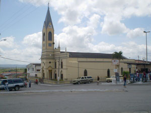
imagesize = 250px
image_caption = Church of Nossa Senhora da Piedade
nickname =
motto =
image_

mapsize = 250px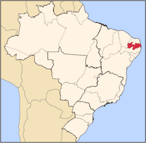
map_caption = Location of Arara in the State of Paraíba
subdivision_type = Country
subdivision_type1 = Region
subdivision_type2 = State
subdivision_name = flag|Brazil
subdivision_name1 = Northeast
subdivision_name2 =
leader_title =Mayor
leader_name = José Ernesto (PMDB)
established_title = Founded
established_date =December 1 ,1961
area_magnitude = 1 E8
area_total_km2 = 88,858
area_total_sq_mi = 34.3
elevation_m = 467
elevation_ft = 1,532
population_as_of = 2007
population_total = 12920
population_metro =
population_density_km2 = 145.4
population_density_sq_mi = 3766
timezone = BST
utc_offset = -3
timezone_DST =
utc_offset_DST =
blank_name = HDI (2000)
blank_info = 0.551 – medium
website = [http://www.arara.pb.gov.br Arara, Paraíba]Arara is a municipality in the state of
Paraíba in northeasternBrazil . It is located in the mesoregion of Agreste Paraibano and the microregion of Western Curimataú, 142 km from the state capital,João Pessoa . It is located on the high plain of Borborema at an altitude of 467 m above sea level.History
Originally, the area was occupied by the Cariri people. The countryside was covered in trees whose wood was black, known in the local indigenous language as Baraúna. The trees served as shelter for people traveling to the nearby areas of Brejo and Curimataú to buy flour,
cassava andrapadura , basic foods available in those areas. The area was known as "Baraúnas das Araras" because of the large number ofmacaw s (pt icon: arara) that could be found there up to the year1860 .In the same season, the priest José Antônio Maria Ibiapina arrived in the area from
Ceará . He had greatly influenced the civilizing of the Curimataú area. He founded the Santa Fé sanitarium near the site of today's city, on land donated by Major Antônio José da Cunha, owner of lime deposits in the area.Major Antônio José da Cunha also built the first house in the future village of Arara, and contributed much to its development up to
1881 , when he died at the age of 94.Padre Ibiapina also founded the Mother Church of Arara, under the name of Nossa Senhora da Piedade (Our Lady of Piety), and provided services to the forming community. By
1876 , the village had about 80 houses and 500 inhabitants.In 1937 and 1938, in the administrative division of Brazil, Arara was mentioned as part of the municipality of
Serraria . On1 December 1961 , the town was separated from Serraria and incorporated as a separate municipality. Many people worked toward this goal, including Dr. Marinésio Moreno, Dr. Mário Moreno, and Marísio da Cunha Moreno.Climate
Located on a high plain, the city has a
Semi-arid climate , with average annual temperatures in the range of 24ºC. The rainy season begins in January or February, and continues to September or October.Demographics
According to the
IBGE (Brazilian Institute of Geography and Statistics) of2008 , there were 12,698 people residing in the municipality. The population density was 142,9 inh./km².The last census the
IBGE of2000 , revealed the following numbers: 7,109Pardo (Brown) people (61.66%), 4,033 White people (34.98%), 350 Black people (3,03%).List of Mayors
External links
*pt icon [http://www.sudema.pb.gov.br/geoprocessamento/MAPAS/municipios_estado_ibge/arara.htm Brazilian government data sheet]


Wikimedia Foundation. 2010.