- Chellala District
-
Chellala District
دائرة شلالة— District — Map of Algeria highlighting El Bayadh Province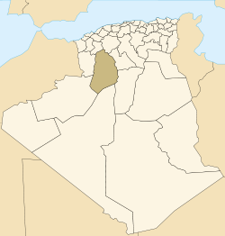
Country  Algeria
Province El Bayadh District seat Chellala Area - Total 3,164 km2 (1,221.6 sq mi) Population (2005) - Total 5,883 - Density 1.9/km2 (4.8/sq mi) Time zone CET (UTC+01) Municipalities 2 Chellala is a district in El Bayadh Province, Algeria. It was named after its capital, Chellala.
Municipalities
The district is further divided into 2 municipalities:
 El Bayadh Province
Chellala District 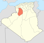
Brézina District Rogassa District Boualem District Boualem · Sidi Slimane · Stitten · Sidi Taifour · Sidi AmarBougtob District Bougtob · El Kheiter · TousmoulineEl Bayadh District Boussemghoun District El Abiodh Sidi Cheikh District El Abiodh Sidi Cheikh • El Bnoud • Aïn El Orak • ArbaouetCategories:- El Bayadh Province
- Districts of Algeria
- Algeria geography stubs


Wikimedia Foundation. 2010.