Métlili District

Métlili District
Métlili District
دائرة متليلي
—  District  —
Map of Algeria highlighting Ghardaïa Province
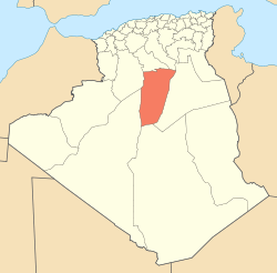
Map of Ghardaïa Province highlighting Métlili District
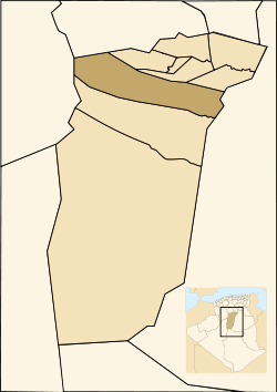
Country  Algeria
Province Ghardaïa
District seat Métlili
Area
 – Total 12,940 km2 (4,996.2 sq mi)
Population (2005)
 – Total 43,486
 – Density 3.4/km2 (8.7/sq mi)
Time zone CET (UTC+01)
Municipalities 2

Métlili is a district in Ghardaïa Province, Algeria. It was named after its capital, Métlili.

Municipalities

The district is further divided into 2 municipalities:


Wikimedia Foundation. 2010.

Игры ⚽ Поможем решить контрольную работу

Look at other dictionaries:

  • Sebseb — Infobox Algerian Municipality map1 = DZ 47.svg map2 = DZ 4709.svg name1 = Debdeb name2 = سبسب code = 4709 postal = 47230 province = Ghardaïa note1 = district = Métlili note2 = seats = 7 president = order = 1 E+9 m² area1 = 5 640 area2 = 2 178… …   Wikipedia

  • Dhayat Ben Dhahoua —   District   Country  Algeria Province …   Wikipedia

  • Dhayet Bendhahoua —   Commune and town   Country  Algeria Province Ghard …   Wikipedia

  • Mansoura, Ghardaïa — Mansoura, Ghardaia   Commune and town   Country  Algeria Province Ghar …   Wikipedia

  • Metlilli —   Commune and town   Country  Algeria Province Ghardaïa Provi …   Wikipedia

Share the article and excerpts

Direct link
Do a right-click on the link above
and select “Copy Link”