- Rheinfelden
Infobox Swiss town
subject_name = Rheinfelden
municipality_name = Rheinfelden
municipality_type = City
imagepath_coa = Rheinfelden-blason.png|pixel_coa=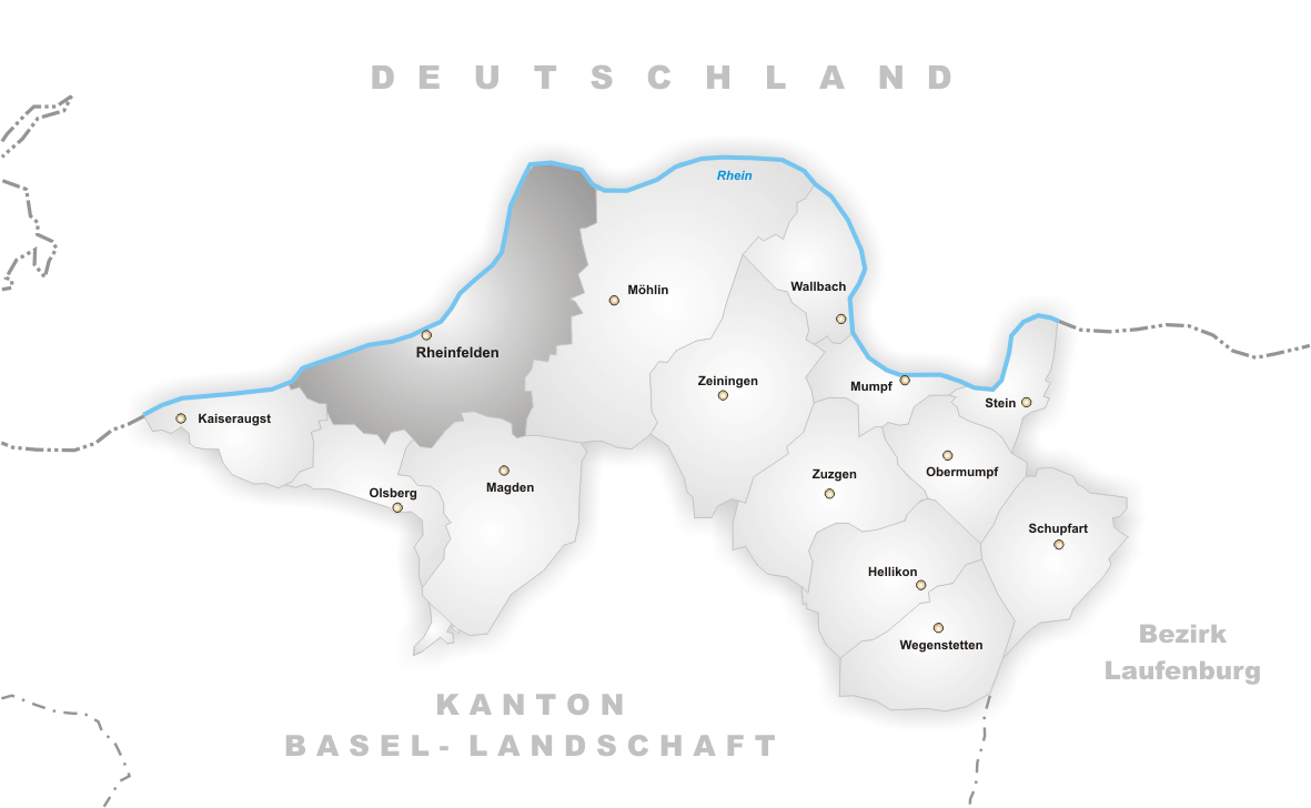
languages = German
canton = Aargau
iso-code-region = CH-AG
district = Rheinfelden
lat_d=47|lat_m=33|lat_NS=N|long_d=7|long_m=48|long_EW=E
postal_code = 4310
municipality_code = 4258
area = 16.12
elevation = 280|elevation_description=
population = 10884|populationof = December 2003 | popofyear = 2003
website = www.rheinfelden.ch
neighboring_municipalities=Kaiseraugst ,Magden ,Möhlin , Olsberg, Rheinfelden (DE-BW),Schwörstadt (DE-BW)
twintowns =
native_name = "Herrschaft (Grafschaft?) Rheinfelden"
conventional_long_name = Lordship (County?) of Rheinfelden
common_name = Rheinfelden|
continent = Europe
region = Alps
country = Switzerland
era = Middle Ages
status = Vassal
empire = Holy Roman Empire
government_type = Principality|
year_start = 10th century
year_end = 1080|
event_pre = First settled
date_pre =Middle Stone Age (10,000 BP)
event_start =
date_start =
event_end = Inherited byZähringen
date_end = |
p1 = County of Burgundy
image_p1 =
s1 = Zähringen
image_s1 = |
capital = Rheinfelden|
footnotes = Infobox Former Country
native_name = "Reichsstadt Rheinfelden"
conventional_long_name = Imperial City of Rheinfelden
common_name = Rheinfelden|
continent = Europe
region = Alps
country = Switzerland
era = Middle Ages
status = City-state
empire = Holy Roman Empire
government_type = Republic|
year_start = 1225
year_end = 1330|
event_pre =Zähringen ducal
line extinct
date_pre =1218
event_start = Gained "Reichsfreiheit "
date_start =
event_end = JoinedHabsburg
Further Austria
date_end =1330 |
p1 = Zähringen
image_p1 =
s1 = Habsburg
image_s1 = |
capital = Rheinfelden|
footnotes =Rheinfelden (langWithName|gsw|Swiss German|"Rhyfälde", IPA2|ˈɾiːfæld̥ə) is a municipality in the canton of
Aargau inSwitzerland , seat of the district of Rheinfelden. It is located 15 kilometres east ofBasel . The name means the fields of theRhine , as the town is located on theHochrhein . It is home toFeldschlösschen , the most popular beer in Switzerland. The city is across the river from Rheinfelden inBaden-Württemberg ; the two cities were joined untilNapoleon Bonaparte fixed the German–Swiss border on the Rhine in 1802 and are still socially and economically tied.The old town of Rheinfelden, the
Neolithic "Hermitage" hill settlement, the late Roman watchtower at the "Pferrichgraben", the Christian Catholic Church "St. Martin" with its treasures and theFeldschlösschen brewery are listed as heritage sites of national significance. [Swiss inventory of cultural property of national and regional significance (1995), p. 44.]Geography
The old town of Rheinfelden lies on the left bank of the Rhine, where the river is divided into two arms by the "Inseli", a roughly 150-metre-long island. This is on the verge of a
tectonic plate , theRhine rift . A huge vortex, "St-Anna-Loch" tears at this point, with water up to fifty metres in depth. Nearly 400 metres east is the "Magdenerbach". The Rhine is navigable by ship from Rheinfelden all the way to theNorth Sea .Around the city center stretches a large
gravel plain. While this stretches just one kilometre wide to the West, it extends to the east to themoraine ofMöhlin with a width of around three kilometres; in the south, the plain is limited through the wooded, gently-rising foothills of the "Tafeljura". These are the Steppberg (373 m abovesea level ) and the "Berg" (419 m), both in the south-east. Between these two hills lie the deeply-incised valleys of the "Magdenerbach".The municipality comprises 1612
hectare s (6¼sq mi ), of which around half isforest ed and 309 hectares (a little over a square mile) are built-up. The highest point (419 m) is located on "Berg", the lowest point (270 m) is on the Rhine. Neighbouring cities areKaiseraugst to the west, Olsberg to the south-west,Magden to the south andMöhlin to the east (all in the Aargau); over the river in Germany lies Rheinfelden, Baden-Württemberg.History
The area around Rheinfelden was already settled in the
Middle Stone Age , around 10,000 years before the present day. At that time, people lived in the "Hermitage", a small natural cave next to the current highway. In the year 45 BC, a few kilometres further west, the settlementAugusta Raurica was founded, the first Roman town in Switzerland, near modernKaiseraugst . In the plains at Rheinfelden was then a large estate. Towards the end of the 4th century a border fort was constructed at the western settlement.In the second half of the 10th century, when the entire
Fricktal area was within Kingdom of Burgundy, Rheinfelden was granted to a noble family, later calling themselves Counts of Rheinfelden. They built a fortress, "Stein", on the strategically-located island; a riverbank settlement stood at the "Altenburg". The last of this comital line wasRudolf of Rheinfeld en,Duke of Swabia (1057–79) and Germanantiking (1077–80) during theInvestiture Controversy .When Rudolf died without issue on
October 15 ,1080 inMerseburg , his territories were inherited by Berthold II of Zähringen. Berhold's second son, Conrad, awarded market rights to the city, making it the oldestZähringerstadt in Switzerland and the oldest city in theAargau ; in 1150 he also had the first bridge built across the Rhine, betweenKonstanz andStrasbourg . In 1218, Berthold V died without issue; in 1225, Rheinfelden gained "Reichsfreiheit " to become an Imperial City.A little over a century later, in 1330, the city pledged itself to the
Habsburg s, becoming a part ofFurther Austria . In 1445, when the Habsburgs were fighting theOld Zürich War , insurgents destroyed the castle on the "Inseli", due to the city's allegiance withBasel . After a siege lasting several months, Rheinfelden was returned to Austrian subjugation in 1449. After theWaldshut War from 1468, all ofFricktal Burgundy pledged to the Habsburgs. After the Burgundians were beaten by theOld Swiss Confederacy in theBurgundian Wars , Rheinfelden was restored to Austria in 1477.During the 17th century, there was very little time during which the city enjoyed peace. During the Rappenkrieg, a peasant uprising that lasted from 1612 until 1614, the city was unsuccessfully besieged but devastated. Between 1633 and 1638 the
Thirty Years' War reached Fricktal, where Rheinfelden played an important role. On15 July 1633 , Swedish and French troops devastated the city. On5 February 1638 , the city was besieged by Protestant troops under the command ofBernhard of Saxe-Weimar . On 28 February theBattle of Rheinfelden began, as the city was attacked by numerically-superior Imperial and Bavarian troops under the command ofJohann von Werth andFederigo Savelli . The Protestants lost this encounter and moved on. Bernhard brought them weapons, but in the second passage on 3 March they were heavily defeated, as he and his men unexpectedly re-appeared on the battlefield, with Savelli and Werth falling into captivity.By the end of the Thirty Years' War, the Austrians had built a fortress on the island to secure the southwestern border of the
Breisgau . In 1678, French troops under the command ofFrançois de Créquy fired at the city. In 1745, during theWar of the Austrian Succession , the French made a fortress on the same ground and also blasted a portion of the city wall. On17 July 1796 Rheinfelden was again occupied and looted by the French.As a result of the
Treaty of Campo Formio in 1797, the Fricktal became a French protectorate, forming thefront line between theFrench Revolution ary and theAustria n troops in theWar of the Second Coalition . On20 February 1802 Rheinfelden was made a district capital of the newly createdCanton of Fricktal , joining theHelvetic Republic in August, the point at which the city became decisively Swiss. After the removal of the governorSebastian Fahrländer at the end of September 1802, the seat of the cantonal government was relocated here from Laufenburg. With the beginning of the "Reichsdeputationshauptschluss" (theGerman Mediatisation ),Napoleon Bonaparte dissolved the canton of Fricktal. Since19 March 1803 , Rheinfelden has been the capital of a district of the same name, in thecanton of Aargau . With the "Reichsdeputationshauptschluss", the remaining (German) parts of the city lost their independence to theGrand Duchy of Baden , becomingRheinfelden, Germany .References
External links
* [http://www.rheinfelden.ch/ Official website]
* [http://www.feldschloesschen.com/engl/frameset.htm Feldschlösschen brewery]
Wikimedia Foundation. 2010.