- 1917 Atlantic hurricane season
Infobox hurricane season
Basin=Atl
Year=1917
Track=1917 Atlantic hurricane season reanalysis1.jpg
First storm formed=July 6, 1917
Last storm dissipated=October 20, 1917
Strongest storm name=#4
Strongest storm winds=130
Strongest storm pressure=928
Average wind speed=
Total depressions=9
Total storms=4
Total hurricanes=2
Total intense=2
Fatalities=5 total
Da
Inflated=0
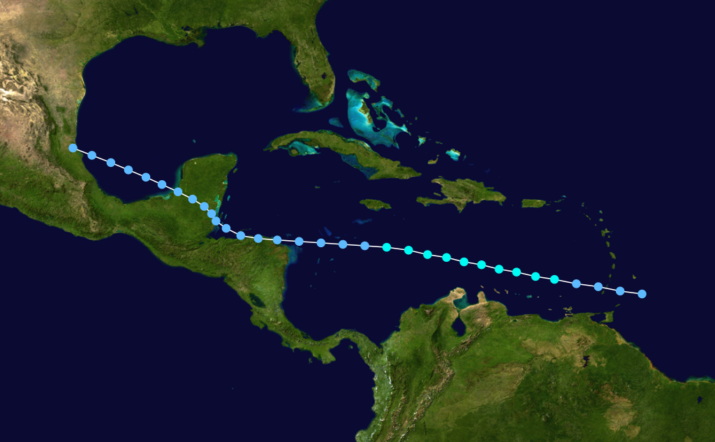
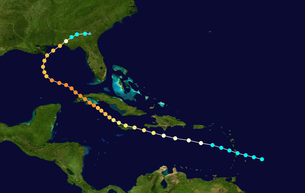
five seasons=1915, 1916, 1917, 1918, 1919 The 1917 Atlantic hurricane season ran through the summer and the first half of fall in 1917. It was an inactive season. Only four tropical cyclones formed this season. Two of them were hurricanes; the other was atropical storm that stayed out to sea. The firstAtlantic hurricane stayed largely out to sea. It passed about a dozen miles offBermuda but did little else. The second hurricane was the most destructive. It kept close to the islands of theGreater Antilles , passing overCuba as a strong Category 4 hurricane.cite web|author=Hurricane Research Division|url=http://www.aoml.noaa.gov/hrd/hurdat/metadata_19151920_new.html|title=HURDAT Meta-Data|publisher=NOAA|accessdate=2008-02-15] After moving into theGulf of Mexico , it swerved northeast toward theFlorida Panhandle . It hit near Fort Walton Beach as a Category 3 hurricane and dissipated inland. The hurricane killed five people and caused $170,000 in damage in theUnited States .torms
Tropical Storm One
Infobox Hurricane Small
Basin=Atl
Formed=July 6
Dissipated=July 14, 1917
1-min winds=45
Pressure=940On July 6, a tropical depression formed near the island of Barbados. It strengthened to a tropical storm and attained peak winds of 50 mph (80 km/h) in theCaribbean Sea on July 8. Later, it weakened on July 9, and it degenerated into an area of low pressure prior to hittingHonduras . It transversed theBay of Campeche , crossing the coast nearTampico, Tamaulipas and dissipating on July 14. Originally, it was not recorded until theAtlantic hurricane reanalysis project added the system to the Atlantic hurricane database.Tropical Storm Two
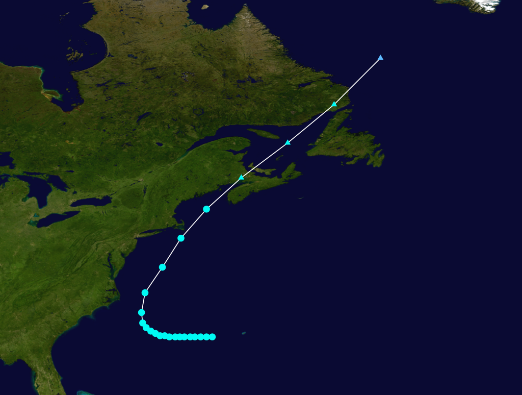
Infobox Hurricane Small
Basin=Atl
Formed=August 6
Dissipated=August 11, 1917
1-min winds=60
Pressure=This strong tropical storm remained off theEast Coast of the United States , though it produced sustained winds of 65 mph (105 km/h) atNantucket Shoals Light . Four fishing vessels disappeared during the storm. It moved over Newfoundland as anextratropical cyclone on August 11.Hurricane Three
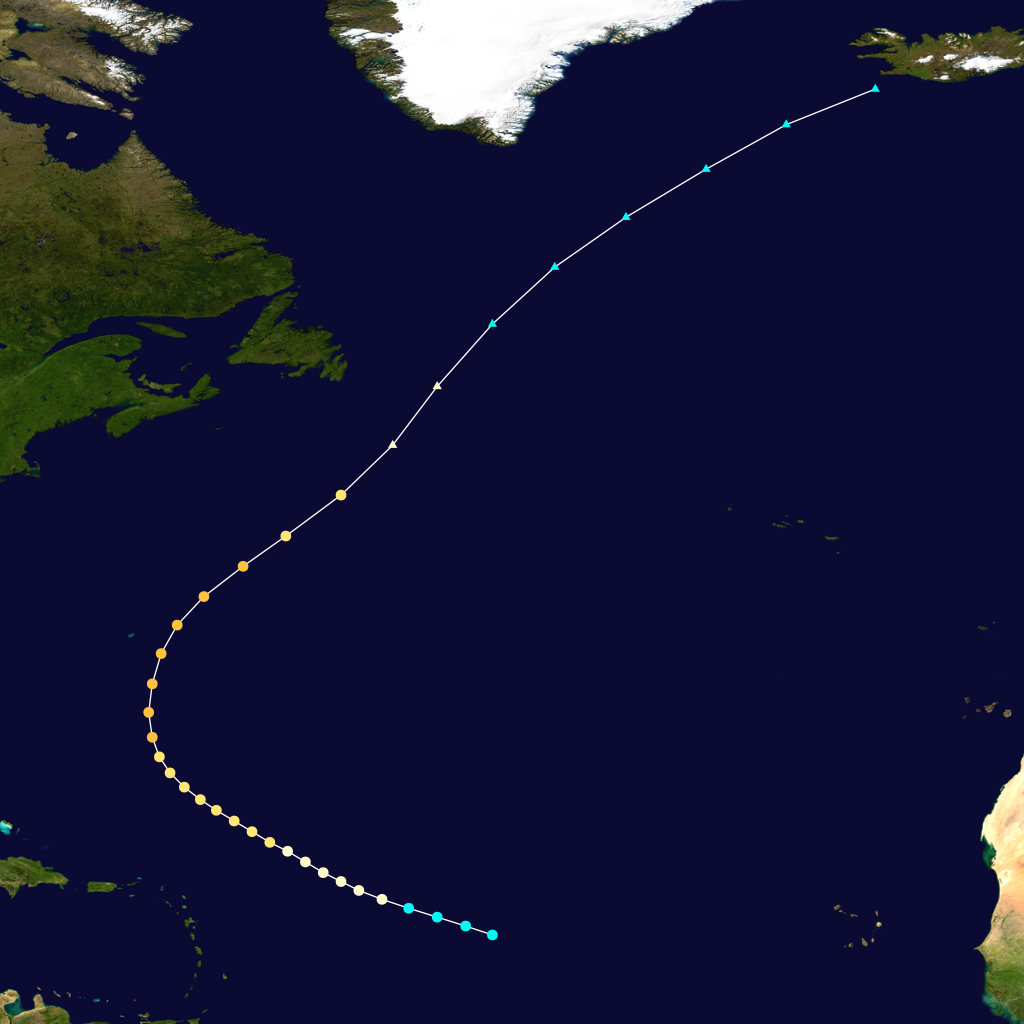
Infobox Hurricane Small
Basin=Atl
Formed=August 30
Dissipated=September 7, 1917
1-min winds=105
Pressure=On August 30, a tropical storm was detected 1,295 miles (2,085 km) east-southeast ofAnguilla . It was likely aCape Verde-type hurricane , but evidence is inconclusive because of scarce observations in the eastern Atlantic Ocean. It intensified to a hurricane on August 31, moving west-northwest through the North Atlantic. It remained north of the Lesser Antilles, and it intensified to peak winds of 120 mph (190 km/h) on September 4. It passed within 120 miles (195 km) ofHamilton, Bermuda , and it transitioned to an extratropical storm on September 6. The maximum winds of the storm are estimated, though high waves at Bermuda suggested that the cyclone reached major hurricane strength on the Saffir-Simpson Hurricane Scale.Hurricane Four
Infobox Hurricane Small
Basin=Atl
Formed=September 20
Dissipated=September 30, 1917
1-min winds=130
Pressure=928The strongest tropical cyclone of the season formed near theWindward Islands on September 20. It strengthened to a peak intensity of 150 mph (240 km/h) prior to landfall in Cuba on September 25. Later, it struck the Florida Panhandle east of Pensacola, Florida on September 29. It was the most intense hurricane in northwest Florida until Hurricane Opal in 1995.References
ee also
*
List of tropical cyclones
*List of Atlantic hurricane seasons External links
* [http://www.aoml.noaa.gov/general/lib/lib1/nhclib/mwreviews/1917.pdf Monthly Weather Review]

Wikimedia Foundation. 2010.