- Wormerland
Infobox Settlement
official_name = Wormerland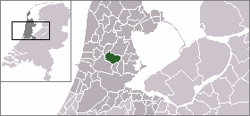
mapsize = 280px
flag_size = 150x75px
image_shield = Wormerland wapen.png
subdivision_type = Country
subdivision_name =Netherlands
subdivision_type1 = Province
subdivision_name1 =North Holland
leader_name = P.C. Tange
leader_party =GroenLinks
area_footnotes = (2006)
area_total_km2 = 45.14
area_land_km2 = 38.80
area_water_km2 = 6.34
population_as_of =1 January ,2007
population_note = Source: CBS, [http://statline.cbs.nl/ Statline] .
settlement_type = Municipality
population_total = 15867
population_density_km2 = 409
timezone = CET
utc_offset = +1
timezone_DST = CEST
utc_offset_DST = +2
latd = 52.50
latNS = N
longd = 4.82
longEW = E
website = [http://www.wormerland.nl www.wormerland.nl].
Population centres
The municipality of Wormerland consists of the following cities, towns, villages and/or districts: Jisp, Neck,
Oostknollendam ,Spijkerboor ,Wijdewormer , Wormer.It borders the municipalities
Beemster ,Graft-De Rijp ,Zaanstad ,Oostzaan ,Landsmeer andPurmerend .Local government
The municipal council of Wormerland consists of 17 seats, which are divided as follows:
PvdA - 4 - 25,21% - 1842 votes
GroenLinks - 4 - 19,86% - 1451 votes Liberaal WL - 3 - 21,09% - 1541 votes
VVD - 3 - 17,13% - 1252 votes
CDA - 3 - 16,71% - 1221 votesSport facilities
Football:
WSV'30 (Wormer Sport Vereniging 1930) - Wormer
VV Jisp - Jisp
VV Knollendam - Oostknollendam
DZS (De Zilveren Schapen) - Neck/Wijdewormer
PSCK (Parochiële Sport Club Kalf) - Kalf (Located in Wijdewormer)
ZCFC (Zaandamse Christelijke Football club) - Zaandam (Located in Wijdewormer)
Wikimedia Foundation. 2010.