- Tataouine
Infobox Settlement
official_name =Tataouine
other_name =
native_name =
nickname =
settlement_type =
motto =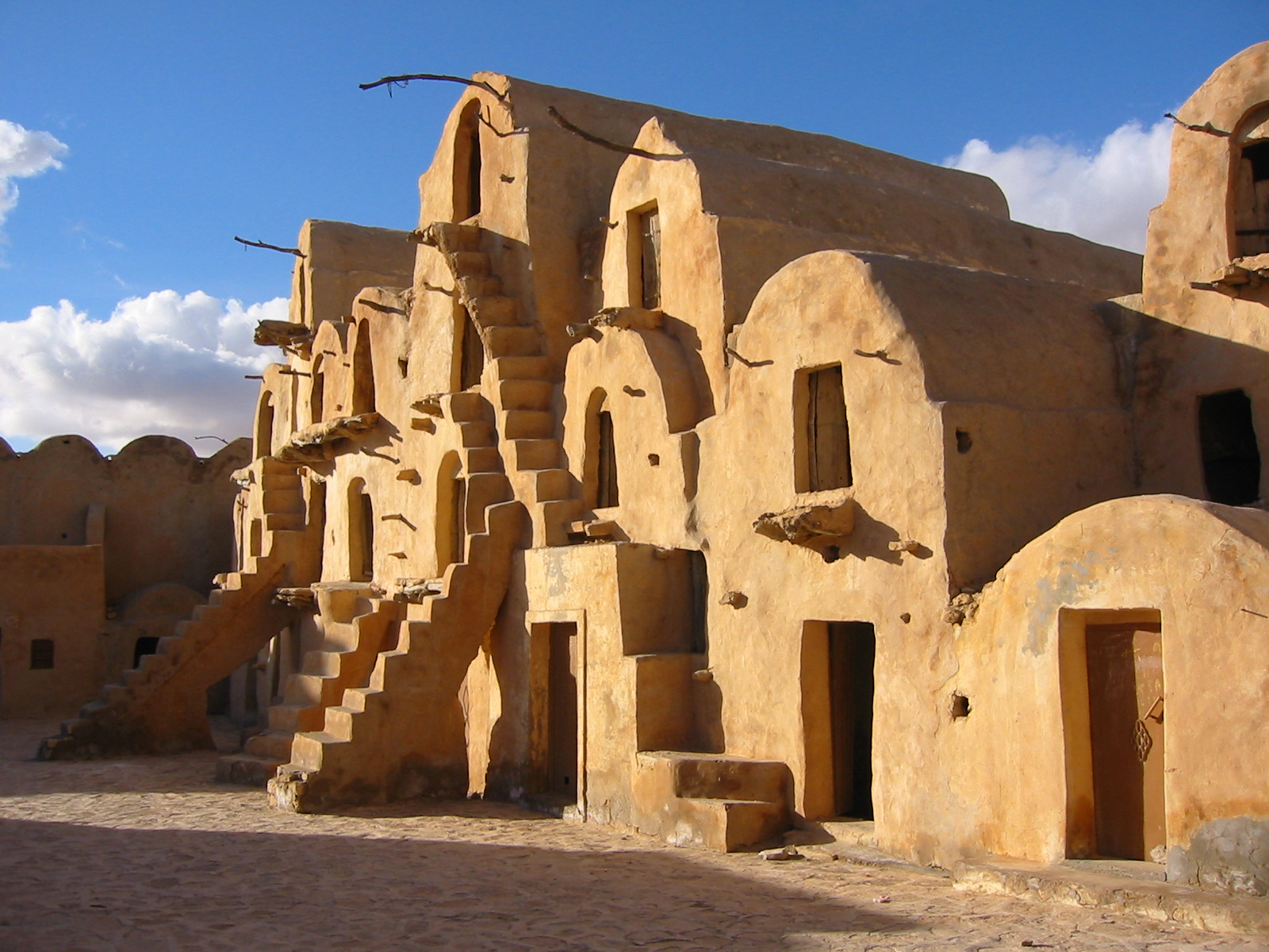
imagesize = 300px
image_caption =Ksar Ouled Soltane , near the city of Tataouine
flag_size =
image_
seal_size =
image_shield =
shield_size =
image_blank_emblem =
blank_emblem_type =
blank_emblem_size =
mapsize =
map_caption =
mapsize1 =
map_caption1 =
image_dot_
dot_mapsize =
dot_map_caption =
dot_x = |dot_y =
pushpin_
pushpin_label_position =bottom
pushpin_map_caption =Location in Tunisia
subdivision_type = Country
subdivision_name =
subdivision_type1 = Governorate
subdivision_name1 =Tataouine Governorate
subdivision_type2 =
subdivision_name2 =
subdivision_type3 =
subdivision_name3 =
subdivision_type4 =
subdivision_name4 =
government_footnotes =
government_type =
leader_title =
leader_name =
leader_title1 =
leader_name1 =
leader_title2 =
leader_name2 =
leader_title3 =
leader_name3 =
leader_title4 =
leader_name4 =
established_title =
established_date =
established_title2 =
established_date2 =
established_title3 =
established_date3 =
area_magnitude =
unit_pref =Imperial
area_footnotes =
area_total_km2 =
area_land_km2 =
area_water_km2 =
area_total_sq_mi =
area_land_sq_mi =
area_water_sq_mi =
area_water_percent =
area_urban_km2 =
area_urban_sq_mi =
area_metro_km2 =
area_metro_sq_mi =
area_blank1_title =
area_blank1_km2 =
area_blank1_sq_mi =
population_as_of =2004
population_footnotes =
population_note =
population_total =59,346
population_density_km2 =
population_density_sq_mi =
population_metro =
population_density_metro_km2 =
population_density_metro_sq_mi =
population_urban =
population_density_urban_km2 =
population_density_urban_sq_mi =
population_blank1_title =Ethnicities
population_blank1 =
population_blank2_title =Religions
population_blank2 =
population_density_blank1_km2 =
population_density_blank1_sq_mi =
timezone = CET
utc_offset = 1
timezone_DST =
utc_offset_DST =
latd=32 |latm=55 |lats=32 |latNS=N
longd=10|longm=26|longs=39|longEW=E
coordinates_type = region:TN_type:city
coordinates_display = display=inline,title
elevation_footnotes =
elevation_m =
elevation_ft =
postal_code_type =
postal_code =
area_code =
blank_name =
blank_info =
blank1_name =
blank1_info =
website =
footnotes = Tataouine ( _ar. تطاوين; also transliterated as "Tatooine", "Tatahouine", "Tatahouïne", "Taţāwīn" or "Tatawin", as well as "Fum Taţāwīn", "Fumm Tattauin", "Foum Tatahouine", "Fum Tatawin", or "Foum Tataouine") is acity located in southernTunisia at coord|32|55|32|N|10|26|39|E |region:TN_type:city. It is the capital of theTataouine Governorate .The district is famous for its
ksour (fortified Berber granaries) including the picturesqueKsar Ouled Soltane ,Chenini andDouiret . These abandoned settlements feature beautiful vaulted adobe buildings, orghorfas .On June 27, 1931, a
meteorite of the rareachondrite type impacted at Tataouine; about 12 kg of fragments were found. The mineral of this meteorite was namedDiogenite .Tataouine's name became famous when
George Lucas , who filmed the original "Star Wars "film in various locations of Tunisia (for example, the Lars Homestead, filmed at the Hotel Sidi Driss inMatmata ), namedLuke Skywalker 's fictional homeplanet Tatooine .Tataouine appeared in the end of the movie "
The X-Files " as Foum Tataouine, where an extraterrestrial viral experiment facility was held.External links
* [http://tunisia.ianandwendy.com/ Pictures and photos of Tunisia, including Tataouine]
* [http://asap.ap.org/stories/319404.s The Real Star Wars?] - Associated Press article, videos and photo gallery about Matmata byAndy Carvin
* [http://www.andycarvin.com/archives/2005/11/ksar_oueld_solt.html QuickTime VR image] ofKsar Ouled Soltane , also photographed byAndy Carvin
*
* [http://www.explo-guide.com/ksours-et-ghorfas-urbanism Travel tips to visit Tataouine ghorfas]

Wikimedia Foundation. 2010.