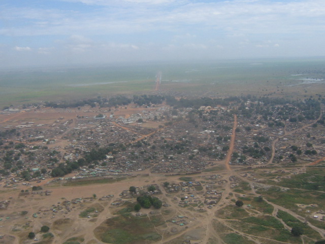
- Aweil, Sudan
Infobox Settlement
official_name = Aweil
other_name =
native_name =
nickname =
settlement_type =
motto =
imagesize = 300px
image_caption = Aerial photo of Aweil (2007). Note the disused railway and large airfield
flag_size =
image_
seal_size =
image_shield =
shield_size =
image_blank_emblem =
blank_emblem_type =
blank_emblem_size =
mapsize =
map_caption =
mapsize1 =
map_caption1 =
image_dot_
dot_mapsize =
dot_map_caption =
dot_x = |dot_y =
pushpin_
pushpin_label_position =bottom
pushpin_map_caption =Location in Sudan
subdivision_type = Country
subdivision_name =
subdivision_type1 = Admin. division
subdivision_name1 =North Bahr al Ghazal State
subdivision_type2 =
subdivision_name2 =
subdivision_type3 =
subdivision_name3 =
subdivision_type4 =
subdivision_name4 =
government_footnotes =
government_type =
leader_title =Mayor
leader_name =
leader_title1 =
leader_name1 =
leader_title2 =
leader_name2 =
leader_title3 =
leader_name3 =
leader_title4 =
leader_name4 =
established_title =
established_date =
established_title2 =
established_date2 =
established_title3 =
established_date3 =
area_magnitude =
unit_pref =Imperial
area_footnotes =
area_total_km2 =
area_land_km2 =
area_water_km2 =
area_total_sq_mi =
area_land_sq_mi =
area_water_sq_mi =
area_water_percent =
area_urban_km2 =
area_urban_sq_mi =
area_metro_km2 =
area_metro_sq_mi =
area_blank1_title =
area_blank1_km2 =
area_blank1_sq_mi =
population_as_of =
population_footnotes =
population_note =
population_total =
population_density_km2 =
population_density_sq_mi =
population_metro =
population_density_metro_km2 =
population_density_metro_sq_mi =
population_urban =
population_density_urban_km2 =
population_density_urban_sq_mi =
population_blank1_title =Ethnicities
population_blank1 =
population_blank2_title =Religions
population_blank2 =
population_density_blank1_km2 =
population_density_blank1_sq_mi =
timezone =
utc_offset =
timezone_DST =
utc_offset_DST =
latd=8 |latm=46 |lats= |latNS=N
longd=27 |longm=24 |longs= |longEW=E
elevation_footnotes =
elevation_m =
elevation_ft =
postal_code_type =
postal_code =
area_code =
blank_name =
blank_info =
blank1_name =
blank1_info =
website =
footnotes = Aweil is the capital city of the South Sudanese state ofNorth Bahr al Ghazal . Its population is in the range of 15,000, though this fluctuates throughout the year as rural villagers seek refuge in the city during the floods of therainy season . The city hosts a team site of theUnited Nations Mission in Sudan and a number ofnon-governmental organizations providing aid.
Transport
Aweil has a railway station on the line to
Waw .References
* [http://www.fallingrain.com/world/SU/32/Uwayl.html FallingRain Map - elevation = 472m (Red dots are railways)]
Wikimedia Foundation. 2010.

