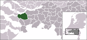
- Steenbergen
Infobox Settlement
official_name = Steenbergen
mapsize = 280px
subdivision_type = Country
subdivision_name =Netherlands
subdivision_type1 = Province
subdivision_name1 =North Brabant
area_footnotes = (2006)
area_total_km2 = 158.79
area_land_km2 = 146.61
area_water_km2 = 12.18
population_as_of =1 January ,2007
population_note = Source: CBS, [http://statline.cbs.nl/ Statline] .
settlement_type = Municipality
population_total = 23307
population_density_km2 = 159
timezone = CET
utc_offset = +1
timezone_DST = CEST
utc_offset_DST = +2Steenbergen (pronunciation|226 Steenbergen.ogg) is a
municipality and a city in the South of theNetherlands .Steenbergen means Stone mountains in Dutch. The municipality is mainly agricultural, but the towns of Steenbergen and Dinteloord also contain some light industry.
Guy Gibson , Wing Commander and the first CO of theRAF 's617 Squadron which he led in the "Dam Busters " raid in 1943, crashed with his Mosquito aircraft in this municipality; both he and his co-pilot died. They were buried at the local cemetery. Their graves are still there. A street has been named after Gibson as well. The propellor of their aircraft can still be seen in the city park.Population centres
*Steenbergen (population: 12,440)
*Dinteloord (5,680)
*Nieuw-Vossemeer (2,400)
*Kruisland (2,340)
*De Heen (580)The city of Steenbergen
Steenbergen received city rights in
1272 .External links
* [http://www.gemeente-steenbergen.nl Official Website]

Wikimedia Foundation. 2010.