- Reimerswaal
Infobox Settlement
official_name = Reimerswaal
mapsize = 280px
subdivision_type = Country
subdivision_name =Netherlands
subdivision_type1 = Province
subdivision_name1 =Zeeland
area_footnotes = (2006)
area_total_km2 = 243.08
area_land_km2 = 102.23
area_water_km2 = 140.85
population_as_of =1 January ,2007
population_note = Source: CBS, [http://statline.cbs.nl/ Statline] .
settlement_type = Municipality
population_total = 21111
population_density_km2 = 207
timezone = CET
utc_offset = +1
timezone_DST = CEST
utc_offset_DST = +2The name Reimerswaal (Pronunciation|246 Reimerswaal.ogg) can mean:
*A lost city in the
Netherlands : see below.*A
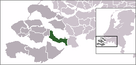
municipality in the southwesternNetherlands onZuid-Beveland , named after the lost city. Reimerswaal is amunicipality in the province ofZeeland . The municipality in 2004 had 20,966 inhabitants, and has a surface of 243.70 km² (of which 133.89 km² are water). The central townYerseke is known for the trade inmussel s andoyster s.Kruiningen is known for the formerferry from Kruiningen to Perkpolder which was in service up to 2003. The municipality of Reimerswaal arose in 1970, from the aggregation of the municipalities Krabbendijke, Kruiningen, Rilland-Bath, Waarde, and Yerseke.Population centers
*Bath
*Hansweert
*Krabbendijke
*Kruiningen (location of the government offices)
*Oostdijk
*Rilland
*Waarde
*Yerseke .The city of Reimerswaal
The municipality is named after the
city of Reimerswaal. This city was granted city rights in1374 . The city was destroyed by repeatedflood s, and the last citizens left in1632 . Nothing remains. It was located north of the current municipality, on the east end of theOosterschelde , on land which is now called the "Verdronken Land van Reimerswaal "Transportation
Railway stations (from west to east): Kruiningen-Yerseke, Krabbendijke, Rilland-Bath, all on the railway fromVlissingen toRoosendaal .External links
* [http://www.reimerswaal.nl Official website (in Dutch)]
* [http://www.plattegronden.nl/gemeentereimerswaal/ Map]

Wikimedia Foundation. 2010.