- Ayun Pa
-
Ayun Pa
Thị xã Ayun Pa— Urban district and town — 
 Ayun Pa
Coordinates: 13°23′38″N 108°26′27″E / 13.39389°N 108.44083°ECoordinates: 13°23′38″N 108°26′27″E / 13.39389°N 108.44083°E Country  Vietnam
Region Central Highlands Province Gia Lai Province Area - Total 304.6 sq mi (788.9 km2) Population (2007) - Total 35,058 Time zone UTC + 7 (UTC+7) Ayun Pa is a district-level town (thị xã) in Gia Lai province, in the Central Highlands of Vietnam. It used to be known as Cheo Reo. Ayun Pa covers an area of 788.9 km², with a population of 35,058 (2007). The town is situated in the south-eastern part of Gia Lai Province. To the east and north-east is Ia Pa district, to the south-east is Krông Pa district, to the south is Ea H'leo district, to the west is Phú Thiện district.
Ayun Pa town has 8 subdivisions, including 4 urban wards (phường): Cheo Reo, Hòa Bình, Đoàn Kết, Sông Bờ, and communes (xã): Ia RTô, Chư Băh, Ia Rbol and Ia Sao.
 Districts of Central Highlands (Tay Nguyen)
Dak Lak province Buon Ma Thuot · Buon Don · Buon Ho · Cu Kuin · Cu M'gar · Ea Sup · Krong Ana · Krong Bong · Krong Buk · Krong Nang · Krong Pak · Lak · M'Drak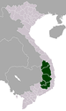
Dak Nong province Gia Lai province Kon Tum province Lam Dong province Categories:- Populated places in Gia Lai Province
- District capitals in Vietnam
- Central Highlands geography stubs


Wikimedia Foundation. 2010.