- Monti Picentini
-
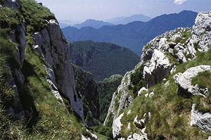 Rocky limestone landscape in the monti Picentini.
The Monti Picentini is a mountain range and national park in southern Italy, part of the Apennines, traditionally part in the Campanian Apennines. They are included between the Monti Lattari, the Partenio mount, the Irpinian plateau and the Sele river valley.
The highest peak is the Monte Cervialto (1,809 m), in the eastern sector, followed by the Monte Terminio (1,783 m), which is instead in the western part of the range.
Geology, landscape and climate
The range is mostly made up of dolostone and limestone rocks, different from the surroundings areas, which are dominated by sandstone rocks. A central depression, joining the valleys of the Calore Irpino and Tusciano rivers, divided the range in two geologically different sectors: the western one, where rocks are predominantly dolostone, and the eastern one, mostly made up of limestone and has generally a less sharp landscape.
Karst topography is widely present, from which, in the valleys below, originates several springs.
Snow is present in winter over 1,000 m of altitude. Vegetation is generally low, somewhere mixed with chestnut woods.
Rivers starting from the Monti Picentini include:
- Sele
- Tusciano
- Picentino
- Calore Irpino
- Sabato
- Ofanto
The following communes lie within the Monti Picentini National Park:
Acerno, Bagnoli Irpino, Calabritto, Calvanico, Campagna, Caposele, Castelvetere sul Calore, Castiglione del Genovesi, Chiusano di San Domenico, Eboli, Fisciano, Giffoni Sei Casali, Giffoni Valle Piana, Lioni, Montecorvino Rovella, Montella, Montemarano, Montoro Superiore, Nusco, Olevano sul Tusciano, Oliveto Citra, San Cipriano Picentino, San Mango Piemonte, Santa Lucia di Serino, Santo Stefano del Sole, Senerchia, Serino, Solofra, Sorbo Serpico, Volturara Irpina.
Coordinates: 40°45′N 15°00′E / 40.75°N 15°E
Categories:- Mountain ranges of Italy
- Mountains of Campania
- Campanian geography stubs

Wikimedia Foundation. 2010.