Mariager Fjord

Mariager Fjord
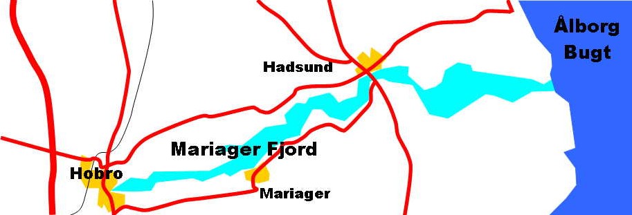
Map of Mariager Fjord with major towns and roads

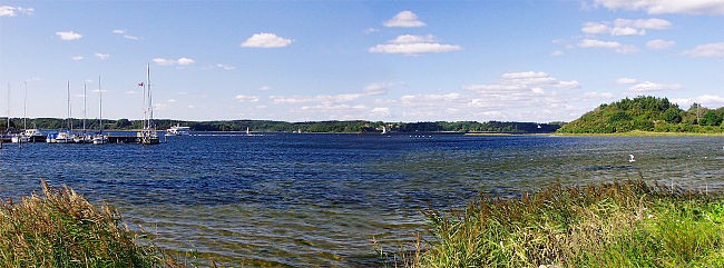
With a length of approximately 35 km (22 statute miles), Mariager Fjord is the longest fjord in Denmark. Mariager Fjord cuts into the Jutland peninsula from the Kattegat sea and ends at the town of Hobro; other important towns along the fjord are Hadsund and Mariager from which the fjord takes its name. Mariager fjord makes up most of the southern limit of the traditional region of Himmerland.

The width of Mariager Fjord varies from 4½ km to 250 metres (2,8-0,16 miles) and its area is about 47 km2s (18 square miles). The depth is up to 30 metres (ca. 100 ft).

As a result of the 2007 Municipal Reform, the new Mariagerfjord municipality was created around Mariager Fjord by fusion of four former municipalities.

Mariager fjord.jpg

Coordinates: 56°41′N 10°02′E / 56.683°N 10.033°E / 56.683; 10.033


Wikimedia Foundation. 2010.

Игры ⚽ Нужна курсовая?

Look at other dictionaries:

  • Mariager Abbey — Mariager Kirke, the much reduced and altered former Mariager Abbey church Mariager Abbey (Danish: Mariager Kloster) was a Bridgettine double monastery founded in 1430 which became an important pilgrimage site, in the present town of Mariager in… …   Wikipedia

  • Mariager — Vorlage:Infobox Ort in Dänemark/Wartung/Fläche fehltVorlage:Infobox Ort in Dänemark/Wartung/Höhe fehlt  Mariager …   Deutsch Wikipedia

  • Fiordo de Mariager — Mapa del fiordo de Mariager con las principales ciudades y carreteras. El fiordo de Mariager (en danés, Mariagfer Fjord), es el más largo de Dinamarca, con 35 km. No obstante, el Isefjorden es casi tan largo como el fiordo de Mariager; Limfjorden …   Wikipedia Español

  • Mariagerfjord (Fjord) — Überwinterung im Fjord Der Mariagerfjord wird oft der schönste Fjord von Dänemark genannt. Der mit 38 Kilometern auch längste echte und stellenweise nur 250 m schmale Fjord ist bis zu 29 m tief. Die breiteste Stelle liegt mit 4,5 Kilometern an… …   Deutsch Wikipedia

  • Mariagerfjord — Der bis zu 29 m tiefe Mariagerfjord ist eine Förde an der Ostseeküste im nördlichen Teil von Jütland (Dänemark). 56.68333333333310.033333333333 Koordinaten: 56° 41′ 0″ N, 10° 2′ 0″ O …   Deutsch Wikipedia

  • Mariagerfjord Municipality — Location of Mariagerfjord municipality Mariagerfjord is a municipality (Danish, kommune) in North Denmark Region in Denmark. It covers an area of 769 km² and a total population of 42,667 (2008) …   Wikipedia

  • Auswahl von Fjorden — Diese Liste stellt eine Auswahl von Fjorden dar, unterteilt nach Ländern. Inhaltsverzeichnis 1 Europa 2 Dänemark 2.1 Deutschland 2.2 Norwegen 2.3 Spitzbergen 2.4 …   Deutsch Wikipedia

  • Liste der Fjorde — Diese Liste stellt eine Auswahl von Fjorden dar, unterteilt nach Ländern. Inhaltsverzeichnis 1 Europa 2 Dänemark 2.1 Deutschland 2.2 Norwegen 2.3 Spitzbergen 2.4 …   Deutsch Wikipedia

  • Förden and East Jutland Fjorde — On the eastern coast of the Cimbrian Peninsula , consisting of Danish Jutland and German Schleswig Holstein, there is a special type of narrow bays, called Förde (plural: Förden ) in German and fjord (plural fjorde ) in Danish. These bays are of… …   Wikipedia

  • Fjorde — Lysefjord in Norwegen Geirangerfjord in Norwegen …   Deutsch Wikipedia

Share the article and excerpts

Direct link
Do a right-click on the link above
and select “Copy Link”