- Mons Rümker
-
Mons Rümker 
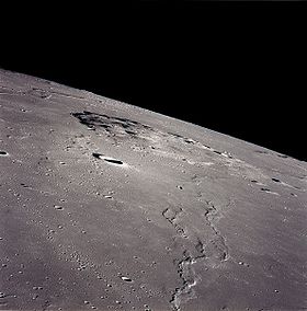
View of Mons Rümker from Apollo 15Elevation 1.1 km Listing Lunar mountains Translation Karl L. C. Rümker (Latin) Location Location the Moon Coordinates 40°48′N 58°06′W / 40.8°N 58.1°W Geology Type Lunar dome Mons Rümker is an isolated volcanic formation that is located in the northwest part of the Moon's near side, at selenographic coordinates 40.8° N, 58.1° W. The feature forms a large, elevated mound in the northern part of the Oceanus Procellarum. The mound has a diameter of 70 kilometres, and climbs to a maximum elevation of about 1,100 metres above the surrounding plain. It was named after Karl L. C. Rümker.
Mons Rümker has a concentration of 30[1] lunar domes—rounded bulges across the top, some of which contain a small craterlet at the peak. These are wide, circular features with a gentle slope rising in elevation a few hundred meters to the mid-point. Lunar domes are the result of lava erupting from localized vents followed by relatively slow cooling.
Mons Rümker is surrounded by a scarp that separates it from the adjacent mare. The plateau rises to an altitude of 900 m in the west, 1,100 m in the south and 650 m in the east. The surface of Mons Rümker is relatively uniform, with a strong spectroscopic signature of lunar mare material. The estimated volume of lava used to create this feature is 1,800 km3.[1]
See also
References
- ^ a b Wöhler, C.; Lena, R.; Pau, K. C. (March 12–16, 2007). "The Lunar Dome Complex Mons Rümker: Morphometry, Rheology, and Mode of Emplacement". Proceedings Lunar and Planetary Science XXXVIII. League City, Texas: Dordrecht, D. Reidel Publishing Co. http://adsabs.harvard.edu/abs/2007LPI....38.1091W. Retrieved 2007-08-28.
Categories:- LQ04 quadrangle
- Mountains on the Moon
- Shield volcanoes
- Lava domes
- Extraterrestrial volcanoes
Wikimedia Foundation. 2010.
