Narberth (hundred)

Narberth (hundred)

Coordinates: 51°47′53″N 4°44′35″W / 51.798°N 4.743°W / 51.798; -4.743

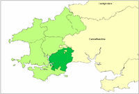
Pembrokeshire showing Narberth Hundred

The Hundred of Narberth was a hundred in Pembrokeshire, Wales. It was formed by the Act of Union of 1536 from parts of the pre-Norman cantrefs of Penfro (the commote of Coedrath) and Cantref Gwarthaf (the commote of Efelfre)[1]. It derives its Welsh name from the town and district of the same name, which means "(district) by the wood", (that is the forest of Coedrath)[2]. The hundred spanned the linguistic boundary, with the parishes of Velfrey being identified by George Owen[3] as Welsh-speaking, and the southern coastal part being English-speaking, part of Little England beyond Wales.

Notes

  1. ^ Charles, B. G., The Placenames of Pembrokeshire, National Library of Wales, Aberystwyth, 1992, ISBN 0-907158-58-7, p 463
  2. ^ Charles, ibid, p 531
  3. ^ Owen, George, The Description of Pembrokeshire Dillwyn Miles (Ed), Gomer, 1994, ISBN 185902-120-4, p 51

Wikimedia Foundation. 2010.

Игры ⚽ Нужно сделать НИР?

Look at other dictionaries:

  • Narberth — may refer to: Narberth, Pembrokeshire, a town in Wales Narberth, Pennsylvania, a town in the United States Narberth (hundred), a traditional hundred of Pembrokeshire in Wales This disambiguation page lists articles about distinct geographical… …   Wikipedia

  • Narberth, Pembrokeshire — Coordinates: 51°47′56″N 4°44′32″W / 51.7989°N 4.7423°W / 51.7989; 04.7423 …   Wikipedia

  • Dewisland (hundred) — Coordinates: 51°56′53″N 5°08′28″W / 51.948°N 5.141°W / 51.948; 5.141 …   Wikipedia

  • Dungleddy (hundred) — Coordinates: 51°52′05″N 4°43′01″W / 51.868°N 4.717°W / 51.868; 4.717 …   Wikipedia

  • Cilgerran (hundred) — Coordinates: 51°59′24″N 4°33′40″W / 51.990°N 4.561°W / 51.990; 4.561 …   Wikipedia

  • Penfro (cantref) — Penfro was one of the seven cantrefi of Dyfed. It subsequently became part of Deheubarth in around 950. It consisted of the long peninsular part of Dyfed south of the Eastern Cleddau and the Daugleddau estuary, and bordered on its landward side… …   Wikipedia

  • Cantref Gwarthaf (Dyfed) — Cantref Gwarthaf was the largest of the seven cantrefi of Dyfed. It subsequently became part of Deheubarth in around 950. It consisted of the southeastern part of Dyfed containing most of the basin of the River Tâf [Richards, Melville, Welsh… …   Wikipedia

  • Pembrokeshire — Pembrokeshire …   Wikipedia

  • Llanteg — infobox UK place country = Wales welsh name=Llanteg constituency welsh assembly=Carmarthen West and South Pembrokeshire (Assembly constituency) latitude= 51.761446 longitude= 04.636811 static official name= Llanteg unitary wales= Pembrokeshire… …   Wikipedia

  • Bala Cynwyd, Pennsylvania — Coordinates: 40°00′27″N 75°14′03″W / 40.0075°N 75.23417°W / 40.0075; 75.23417 …   Wikipedia

Share the article and excerpts

Direct link
Do a right-click on the link above
and select “Copy Link”