- Bedell Covered Bridge
Infobox Bridge
bridge_name=Bedell Bridge
caption=
official_name=
carries=air
crosses=Connecticut River
locale=Newbury, Vermont andHaverhill, New Hampshire
maint=
id=
design=Burr truss covered bridge [ [http://www.ctrivertravel.net/wells-river-woodsville.htm Wells River and Woodsville site] ]
mainspan=
length=396 ft (121 m)
width=
height=
load=
clearance=
below=
traffic=
begin=
complete=1805, 1823, ?, 1866, 1978
open=July 22 ,1979
closed=1823, 1841,1862 ,July 4 ,1866 ,September 14 ,1979
toll=
map_cue=
map_
map_text=
map_width=
coordinates= coord|44|02|43|N|72|04|27|W|region:US_type:landmark|display=inline|name=Bedell Bridge
lat=
long=Infobox nrhp
name = Bedell Covered Bridge
nrhp_type =
caption =
location =
nearest_city =Newbury, Vermont andHaverhill, New Hampshire
lat_degrees = 44
lat_minutes = 2
lat_seconds = 43
lat_direction = N
long_degrees = 72
long_minutes = 04
long_seconds = 27
long_direction = W
locmapin = New Hampshire
area =
built =
architect =
architecture =Burr truss covered bridge
added =May 28 ,1975 [ [http://www.nationalregisterofhistoricplaces.com/NH/Grafton/state.html National Register of Historic Places] ]
visitation_num =
visitation_year =
refnum = 75002171
mpsub =
governing_body = Haverhill, New HampshireThe Bedell Bridge was a
Burr truss covered bridge that spanned theConnecticut River betweenNewbury, Vermont andHaverhill, New Hampshire . Until its most recent destruction in 1979, it was the second longest covered bridge in theUnited States .History
So far, there have been five bridges on this site. The first was built in 1805 and heavily damaged in 1823. Quickly rebuilt that year, it was washed away in 1841. A third bridge was carried away by a spring flood in 1862. The fourth bridge was destroyed in a storm on
July 4 ,1866 . The final bridge, so far, was built that same year. It was in service for over a hundred years until it was closed to traffic in 1968. It was scheduled for demolition in 1973 due to heavy damage that year.A "Save the Bedell Bridge Committee" raised $250,000 to rebuild the bridge, which was completed by 1978 with the associated
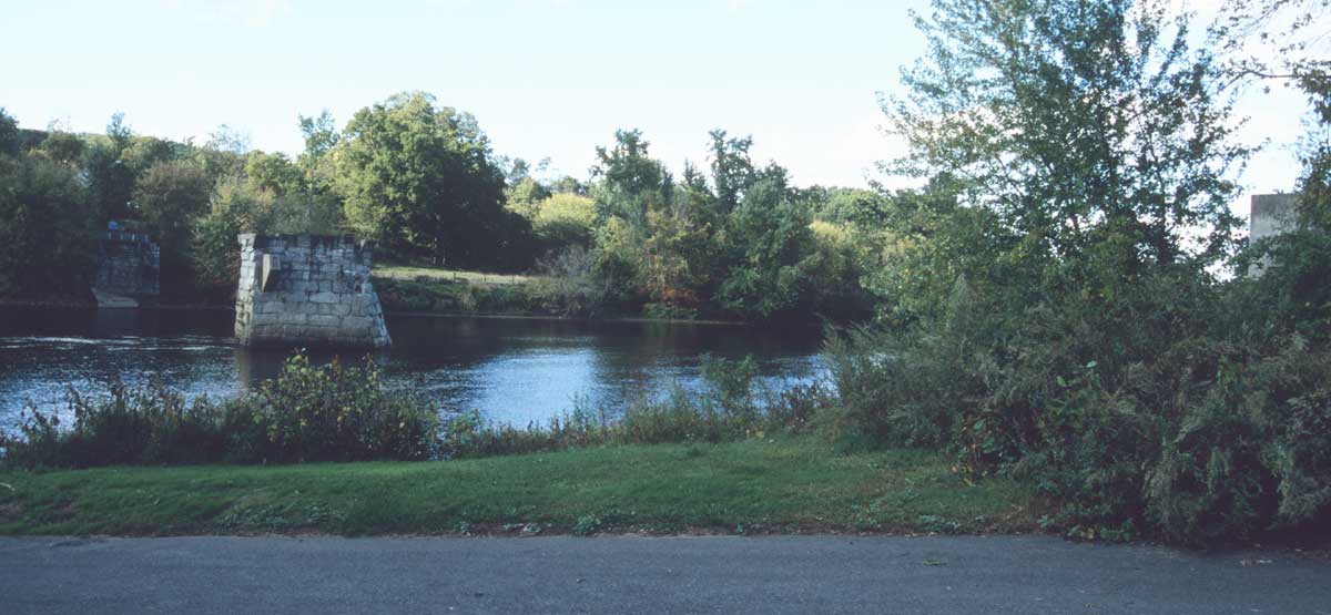
Bedell Bridge State Park . The bridge was rededicated onJuly 22 ,1979 only to be blown away again by a windstorm onSeptember 14 ,1979 . The state park, as well as theabutment s and a pier in the river, are all that remains.Image gallery
See also
*
List of crossings of the Connecticut River References
* cite book
last = Delany
first = Edmund Thomas
authorlink =
coauthors =
title = The Connecticut River: New England's Historic Waterway
publisher = The Globe Pequot Press
date = 1983
location =
pages = p.131
url =
doi =
id =
isbn = 978-0871069801External links
* [http://www.nhparks.state.nh.us/ParksPages/BedellBridge/BedellBridge.html Bedell Bridge State Park official site]
* [http://www.town.haverhill.nh.us/bedellbridge.html Haverhill, New Hampshire Bedell Bridge site]
* [http://www.wildernet.com/pages/area.cfm?areaID=NHSPBD&CU_ID=1 Wildernet site]Crossings navbox
structure = Crossings
place =Connecticut River
bridge = Bedell Bridge
bridge signs =
upstream =Newbury Crossing Road
upstream signs =
downstream = Route 25 bridge
downstream signs =
Wikimedia Foundation. 2010.
